
- HOME
- EXPLORE
- Oceans
- Coasts
- Coastal Decision-making Tools
- Coastal Ecosystem Science
- Coastal Zone Management
- Coastal Monitoring and Observations
- Contaminants in the Environment
- Ecological Forecasting
- Harmful Algal Blooms
- National Estuarine Research Reserves
- Natural Hazards Assessment
- Natural Resource Restoration
- Training and Capacity- Building
- Charting and Navigation
- EDUCATION
- DATA EXPLORER
- NEWS
- OFFICES
- Center for Operational Oceanographic Products and Services
- International Program Office
- Management and Budget Office
- National Centers for Coastal Ocean Science
- National Geodetic Survey
- Office of National Marine Sanctuaries
- NOAA Coastal Services Center
- Office of Coast Survey
- Office of Ocean and Coastal Resources Management
- Office of Response and Restoration
- OUTREACH
- PUBLICATIONS
- WEB SITES
- ABOUT

|
|
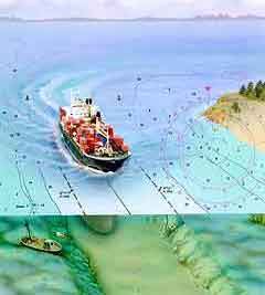
NOAA's National Ocean Service (NOS) has been monitoring sea-level variations for many years. For some U.S. locations, sea-level records exist for more than 100 years. The nation uses water-level data for a variety of practical purposes, including hydrography, nautical charting, maritime navigation, coastal engineering, and tsunami and storm surge warnings. Mariners use the information to advantageously time their approach to and exit from ports. Long-term applications include marine boundary determinations, tidal predictions, monitoring sea-level trends, oceanographic research, and climate research. Bridge, breakwater, and deep-water channel construction also are affected by tidal and current changes.
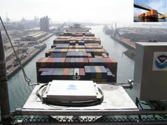
Within NOS, the Center for Operational Oceanographic Products and Services (CO-OPS) is primarily responsible for predicting and measuring water levels and currents and disseminating this information. CO-OPS collects, analyzes, and distributes such data to maintain safe maritime navigation and waterborne commerce.
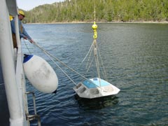
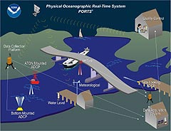
The Center manages the national network of Physical Oceanographic Real-Time Systems (PORTS®), which reside in major U.S. harbors. PORTS® provides real-time information to ship masters and pilots to avoid groundings and collisions. Such information includes water levels, currents, air gap (clearance between the water surface and bridges), and other oceanographic and meteorological data from bays and harbors via telephone voice response and the Internet.
CO-OPS also manages the nation's National Water Level Observation Program (NWLON). NWLON provides basic water-level information to determine U.S. coastal marine boundaries and to create nautical charts. It also supports climate monitoring activities, tsunami and storm surge warning systems, coastal processes, and tectonic research. The network consists of 200 continuously operating water-level measurement stations along the U.S. coasts and the Great Lakes regions, many of which have been operating for more than 50 years. CO-OPS also provides real-time tidal and storm surge information and mean sea level variations and trends for U.S. coastal areas, as well as water level information for the Great Lakes region. In addition, the Center provides predictive information about tides and currents for more than 3,000 locations. |
Educational ResourcesTides and Water Levels Discovery Kit Tides and Currents Lesson Plans
Tide Predictions Accessible from Cell Phones: Spring 2004 The Center for Operational Oceanographic Products and Services (CO-OPS) is primarily responsible for predicting and measuring water levels and currents, and disseminating this information.
NWLON provides basic tidal information to determine U.S. coastal marine boundaries and to create nautical charts. |
||||||||||||||||||||||||
- NOS Program Offices
- Center for Operational Oceanographic Products and Services
- National Centers for Coastal Ocean Science
- NOAA Coastal Services Center
- National Geodetic Survey
- Office of Coast Survey
- Office of National Marine Sanctuaries
- Office of Ocean and Coastal Resource Management
- Office of Response and Restoration

Revised August 23, 2007
| Questions, Comments? Contact Us | Report
Error | Disclaimer | About
the Site | User Survey
National Oceanic and Atmospheric
Administration | U.S.
Department of Commerce | USA.gov
http://oceanservice.noaa.gov/topics/navops/ports/welcome.html