
- HOME
- EXPLORE
- Oceans
- Coasts
- Coastal Decision-making Tools
- Coastal Ecosystem Science
- Coastal Zone Management
- Coastal Monitoring and Observations
- Contaminants in the Environment
- Ecological Forecasting
- Harmful Algal Blooms
- National Estuarine Research Reserves
- Natural Hazards Assessment
- Natural Resource Restoration
- Training and Capacity- Building
- Charting and Navigation
- EDUCATION
- DATA EXPLORER
- NEWS
- OFFICES
- Center for Operational Oceanographic Products and Services
- International Program Office
- Management and Budget Office
- National Centers for Coastal Ocean Science
- National Geodetic Survey
- Office of National Marine Sanctuaries
- NOAA Coastal Services Center
- Office of Coast Survey
- Office of Ocean and Coastal Resources Management
- Office of Response and Restoration
- OUTREACH
- PUBLICATIONS
- WEB SITES
- ABOUT

|
|
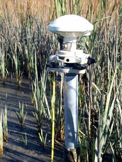
What is Height Modernization?Height Modernization is a program in NOAA’s National Geodetic Survey (NGS) that uses the Global Positioning System (GPS) and other new technologies to increase the accuracy of elevation measurements that comprise the vertical portion of the National Spatial Reference System (NSRS). This system provides the foundation for positioning and navigation activities in the United States. It is the reference base for latitude, longitude, height (elevation), and distance between points on the Earth’s surface and defines the nation’s shoreline.
Why are accurate elevations and the Height Modernization Program important to the nation?For more than 125 years, NGS has set permanent survey marks throughout the United States. Each survey mark is referenced to an exact horizontal and vertical position, defined by latitude, longitude (horizontal), and height (vertical) coordinates. NGS connects these marks together in the NSRS. In the past, NGS employed traditional line-of-sight survey measurements to determine the position of these permanent marks. The process was labor-intensive, time-consuming, and expensive. With the advent of GPS in the 1980s, however, these methods drastically changed (hence the term “modernization”). Developed by the U.S. military, GPS is a constellation of 24 satellites that transmit signals to receivers all over the world. By using GPS, NOAA can determine accurate elevations quickly, inexpensively, and in places where traditional methods are impractical. What benefits will the nation derive from Height Modernization?Reliable elevation data is essential both for scientific inquiry and for safety and convenience. It allows people to measure, for example, how fast a piece of land is sinking (a process called subsidence). It improves aircraft navigational aids to make approach-and-landing procedures safer. Because it precisely pinpoints the rise and fall of land surfaces, it increases the efficiency of water delivery and drainage systems, and helps reduce urban and agricultural runoff and water pollution. For the same reason, it allows more precise modeling of storm-surge and pollution trajectories during extreme weather and hazardous spill events.
Height Modernization also improves disaster preparedness and recovery and infrastructure projects. GPS is especially useful when latitude, longitude, and elevation must be quickly established in areas where the local infrastructure has been largely destroyed; when a construction, public works, or transportation project involves large-scale coverage; and when difficult, rugged terrain lies between survey points. When did the federal government mandate research into Height Modernization?
|
|||||||||||||||||||||||||||||||||||


|
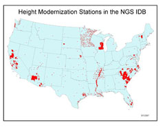
In 1998, the U.S. Congress directed NGS to conduct a National Height Modernization Study to determine the effectiveness of height modernization in two states, California and North Carolina, and its potential benefits to the nation. In 2001, Congress requested additional information from NGS regarding the specific needs and uses for improved height data in two additional states, Wisconsin and Louisiana. These studies were completed in 2002.
Can the same techniques used to improve elevation (vertical) measurements be used to improve latitude and longitude (horizontal) measurements for any point on Earth?
Yes, and they have been. GPS was initially much more accurate in determining horizontal coordinates than vertical ones. Only recently have standards, specifications, and techniques been developed, primarily by NGS in cooperation with the GPS community, that enable GPS to attain the accuracy levels required for most applications using height information.
Where are Height Modernization studies being conducted?
NGS is working with several states in efforts to develop and test more effective ways to improve elevation data. Today, Alabama, Arizona, California, Kentucky, Louisiana, Mississippi, North Carolina, South Carolina, Texas, Washington, and Wisconsin are all working to improve the safety of their residents through Height Modernization.
|
Is there an example of how Height Modernization is being put to use in the “real world”?
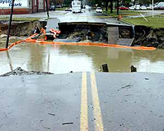
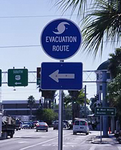
One example can be found in St. Charles Parish, Louisiana, an actively growing region in the southern part of the state and a major evacuation corridor for metropolitan New Orleans. NOS’s Height Modernization Program, in collaboration with the Louisiana Spatial Reference Center at Louisiana State University, completed a study on the Airline Highway (Highway 61) Hurricane Evacuation Route. The study, which focused on elevations and tide and water levels in the Parish, was part of an overall effort to evaluate the elevations of critical evacuation routes in the state and develop specifications and procedures for future surveys.
As part of the St. Charles Parish Water Level Monitoring System, NOS established two real-time National Water Level Observation Network (NWLON) stations at Bayou Gauche, which is connected to Lake Salvador, and at the Labranche Wetlands area of the southern shore of Lake Pontchartrain. NGS conducted a two-week GPS survey to provide up-to-date, accurate heights on a 10-mile portion of the highway and on the NWLON stations. This real-time water-level information was then analyzed to predict flooding of the highway during the hurricane season. The results were presented to the St. Charles Parish Council and Parish Government in November 2003. The data from this survey of the flood-prone portion of Highway 61 will enable the Parish and emergency managers to accurately monitor, predict, and plan for the potential flooding of this heavily traveled route.
Information from the project was used by local officials in prioritizing evacuation routes during the severe hurricane season of 2005. Updated Height Modernization information is also being used to support hurricane recovery, repair, and construction efforts in the area following hurricanes Katrina and Rita.
|
When will Height Modernization techniques be applied uniformly for any point in the United States?
This is an evolving process. The techniques required for Height Modernization are not yet widely practiced by the surveying community. A major effort known as “technology transfer” is being undertaken to introduce these techniques and foster their widespread use. In addition, the existing geodetic reference framework that supports height measurements is outdated in many locations and must be modernized. NGS is meeting this challenge by enhancing the existing framework with a smaller network designed to support and use the technological advances of GPS. It is part of NGS’s continuing mission to make the substantial benefits of Height Modernization available to the nation and the world.
|
Height Modernization is a program in NOAA’s National Geodetic Survey that uses the Global Positioning System and other new technologies to increase the accuracy of elevation measurements that comprise the vertical portion of the National Spatial Reference System.
Height Modernization improves disaster preparedness and recovery and infrastructure projects.
Reliable elevation data is essential both for scientific inquiry and for safety and convenience.
- NOS Program Offices
- Center for Operational Oceanographic Products and Services
- National Centers for Coastal Ocean Science
- NOAA Coastal Services Center
- National Geodetic Survey
- Office of Coast Survey
- Office of National Marine Sanctuaries
- Office of Ocean and Coastal Resource Management
- Office of Response and Restoration

Revised August 23, 2007
| Questions, Comments? Contact Us | Report
Error | Disclaimer | About
the Site | User Survey
National Oceanic and Atmospheric
Administration | U.S.
Department of Commerce | USA.gov
http://oceanservice.noaa.gov/topics/navops/heightmodernization/welcome.html