Pacific Decadal Oscillation (PDO)
 TOPEX/Poseidon is a satellite that measures the precise shape of the ocean's surface and how this
surface changes through time. This helps the scientists to calculate ocean currents, identify climate
trends, and improve weather forecasting models. A recently observed climate trend is the Pacific
Decadal Oscillation.
TOPEX/Poseidon is a satellite that measures the precise shape of the ocean's surface and how this
surface changes through time. This helps the scientists to calculate ocean currents, identify climate
trends, and improve weather forecasting models. A recently observed climate trend is the Pacific
Decadal Oscillation.
See PDO in the Press - News Items
Pacific Decadal Oscillation:
The Pacific Decadal Oscillation (PDO) is a long-term ocean
fluctuation of the Pacific Ocean. The PDO waxes and wanes
approximately every 20 to 30 years. From TOPEX/Poseidon data (see
below) together with other oceans and atmospheres data, scientists think
we have just entered the 'cool' phase. The 'cool' phase is
characterised by a cool wedge of lower than normal sea-surface heights/ocean
temperatures in the eastern equatorial Pacific and a warm horseshoe pattern
of higher than normal sea-surface heights connecting
the north, west and southern Pacific. In the 'warm' or 'positive' phase, which
appears to have lasted from 1977- 1999, the west Pacific
Ocean becomes cool and the wedge in the east warms.
 |
Image at left shows a horseshoe
of higher than average (warm) water in western Pacific Ocean (red and
white), and lower than average (cool) blue and purple water in the eastern
Pacific Ocean. This leads us to believe we have entered the cool
phase of the PDO over this past year, 1999. |
The PDO is an active topic of research and satellite data,
such as that from TOPEX/Poseidon, helps scientists observe and understand
the phenomenon. For further information see our January
2000 press release and articles in the press.
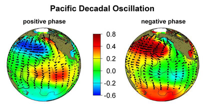
Image courtesy of Stepen Hare and Nathan Mantua, University of Washington,
units are degrees Celsius
More about the Pacific Decadal Oscillation
Q. Who named
the PDO and can you give me more indepth information?
A. The term PDO was
coined in about 1996 by Steven Hare at the University of Washington. He,
along with colleagues Nathan Mantua, Yuan Zhang, Robert Francis and Mike
Wallace discovered the pattern as part of work on fish
population fluctuations. They have online
papers that provide excellent information.
Q. How does this affect
climate?
A. The change in
location of the cold and warm water masses alters the path of the jet stream.
Put simply, the jet stream in the northern hemisphere delivers storms across
the United States. The PDO phase that we appear to have entered will
act to steer the jet stream further north over the Western United States.
Q. How does that affect
the weather and climate in my area?
A. See the NOAA
Climate Prediction Center for weather and climate seasonal outlooks.
Q. If we are entering
a different phase, how long will it last?
A. We don't know,
but based
on past evidence, as shown by scientists Steven Hare and colleagues at
the University of Washington, it is likely to last 20-30 years.
Q. What about El Niño
and La Niña?
A. These will still
continue, they are a pattern that can be thought of as lying on top of
the large scale temperature distribution determined by the Pacific Decadal
Oscillation.
Q. What is the connection
between ocean height as observed by TOPEX/Poseidon and ocean temperature?
A. When the surface
layer of the ocean is warmed it expands and hence results in a higher surface.
Q. Will
we have a drought in southern California?
A.
If the Pacific Decadal Oscillation has switched we are likely to have 20-30
years with lower rainfall that we have had since the late '70's.
We will still have winter rains, but the number of really wet years is
likely to decrease.
Q. I
have heard that some scientists do not agree that the Pacific Decadal Oscillation
has switched, what does this mean?
A.Some
scientists say it's too soon to tell whether the temperature shift is part
of a long-term cycle. Scientists will be studying many types of data
and watching to see how temperature patterns across the Pacific ocean evolve
over time.

