EES Focus AreasEES Group Pages |
ARCHIVE - EES Division Highlights/Accomplishments
December 18, 2006 Unicorn Transparency Success Ken Wohletz (EES-11) organized an NNSA Office of Nonproliferation & International Security - Dismantlement and Transparency (NA-241) Nuclear Testing Limitations (NTL) workshop at the Nevada Site Office in Las Vegas on December 5 and 6. Researchers from SNL, PNNL, LLNL, DOE NNSA, and LANL participated. The focus of the workshop was to review initial results of the multi-lab effort to evaluate monitoring technologies deployed at and near the Unicorn underground sub-critical explosion experiment. A dozen technologies including seismic, infrasound, EM, visual observation, remote sensing, and radiological sampling were fielded. Most activities were conducted within or near the security perimeter of the Unicorn site and fully adhered to the detailed safety, and security requirements and did not interfere with experiment operations. Aviva Sussman (EES-11) and Wohletz presented results of ground-based visual observation and the utilization of the field information management system, which integrates and displays data from all technologies to facilitate interpretation and documentation. Rod Whitaker (EES-2) described observations and results of the infrasound array deployment. Ward Hawkins (EES-11) discussed recent developments and activities of the Ground-based Nuclear Explosion Monitoring R&E program and implications for NTL. This highly successful field activity explored technology utilization and provided significant insights for enhanced test-site transparency and other potential cooperative monitoring applications.
December 11, 2006 Bolide tracking: Infrasound and Photometry Douglas O. ReVelle (EES-2) is arranging collaborations between the Ondrejov Observatory of the Astronomical Institute of the Academy of Sciences of the Czech Republic and the Australian National University (under an existing AFRL contract) to continuously monitor large bolide entry in Western Australia. This monitoring effort will consist of automated fireball observations, optical photometery (fish eye, all-sky cameras), and enhanced infrasonic monitoring techniques using three arrays. Standard methods will be employed to synthesize these routine observations to better calibrate the systems and contribute to the reduction of the false alarm rate for the CTBTO International Monitoring System infrasound network. December 4, 2006 Invited Talk at the Instituto di Astrofisica Spaziale e Fisica Cosmica, Rome, ItalyDouglas ReVelle (EES-2) gave one of only two invited talks at the Instituto di Astrofisica Spaziale e Fisica Cosmica, Rome, Italy. His talk was entitled “Examinations of the Sirente Structure using Hypersonic Aerodynamic Entry Modeling Techniques.” ReVelle was invited because he was named to be a permanent scientific member of the International Sirente Structure Investigation Committee (one of six people chosen worldwide with three from the USA). The talk focused on two ways to determine whether the Sirente structure (120 m in diameter with a 2 m rim around the structure) is a real impact crater. This investigation used hypersonic aerodynamic entry model techniques: both a direct technique from the top of the atmospheric downward including fragmentation processes, and an inverse technique from the bottom-up assuming a single-body model. In these studies, calculations included the specific relationships between the resulting crater size, assuming a target density, an impactor density, and a mean entry angle as well as an impact kinetic energy (predicted by hypersonic atmospheric modeling). From these results, the most probable “meteorite” type to have produced the crater was most likely a carbonaceous chondrite (bolide group II). ReVelle also visited the crater site about three hours east of Rome in the Southern Alps.
Figure 2. Aerial view of the Sirente Structure
Talk on Earthquake Hazards at Bradbury Science Museum Emily Schultz of EES-9 gave a talk at the Bradbury Science Museum on November 27, entitled “Investigating Past Earthquakes on the La Laja Fault System, San Juan Province, Western Argentina.” The talk focused on understanding earthquake activity in regions of blind thrust faults and the seismic hazard to regions of blind thrust faults. A blind thrust fault occurs where the earthquake-generating fault is deep and does not rupture the Earth’s surface. Two studies along the La Laja Fault System near San Juan, Argentina provided a better understanding of seismic hazard to regions of blind thrust faulting. The talk included a discussion of Schultz's master's thesis, which she successfully defended in late October 2006.
Southwest Sciences A CRADA was executed between LANL and Southwest Sciences for development of the Laser-induced breakdown spectroscopy (LIBS) technique as a low-cost, field portable, and automated method for quantifying carbon in soils and sub-soils that will have significant commercial potential. Measurement of carbon in soils is important for determining the capture of carbon and for characterizing soil productivity. The first objective is connected with the monitoring and verification of CO2 sequestration sites. The second can help guide effective land management practices. Both would benefit from the development of fast, low-cost sampling methods. The purpose of the proposed work is to extend fundamental research on LIBS applications to provide an inexpensive yet highly effective analysis instrument for soil carbon determinations. The total CRADA value is $108K. The LANL PI is Ronny Harris (EES-2).
Indiana University TT Division executed a WFO agreement with Indiana University. LANL has developed unique expertise and tools called LaGriT: Los Alamos Grid Toolkit, developed for building finite element meshes for geological applications. Through this project LANL scientists will use LaGriT for building a finite element mesh for modeling flow and transport in faulted geologic settings of the lower Rhine embayment for use in porous flow models. The LANL PI is Carl W. Gable (EES-6). November 27, 2006 Election to Geological Society of America A recent meeting of the Councilors and Officers of the Geological Society of America (GSA) elected Emily Schultz (EES-9) as Member-At-Large to the Committee on Minorities and Women in the Geosciences. This committee advises the GSA council on matters regarding persons of disability, ethnic minority, and women; initiates programs that provide opportunities for women and minorities; and provide strategic planning to the GSA Council and member universities in matters of recruitment and retention of women and minorities in the geosciences. Schultz will serve a three-year term on the committee beginning in July 2007. Paper published in Atmospheric Chemistry and Physics Many questions remain regarding the extent to which secondary aerosols can influence climate, radiative properties, and human health. In addition higher number concentrations of ultrafine particles could have a strong impact on the size distribution of cloud condensation nuclei, which will further affect cloud properties. However, the detailed mechanisms responsible for the formation of new particles in the planetary boundary layer are not completely understood. Therefore, Douglas ReVelle (EES-2) and an international team of collaborators have developed and used the MALTE model to examine aerosol formation in the Earth’s lower troposphere (approximately 10-15 km above the ground). This is the first approach to combine aerosol dynamics, chemistry, and meteorology in a one-dimensional model to investigate the different mechanisms included in the formation of secondary organic aerosols in the planetary boundary layer under realistic atmospheric conditions. This new work is based upon an atmospheric boundary layer model that ReVelle developed over the past decade with Swedish and Finnish colleagues, called BLMARCC [boundary layer, mixing, i.e., turbulence, aerosols, radiation (long-wave and solar), chemistry and clouds]. The results in their Atmospheric Chemistry and Physics publication indicate that the MALTE model is able to predict the on- and offset of new particle formation and the total aerosol number concentrations, in good agreement with the observations made at Kyytiala, Finland. (Figure 2) Comparison of predicted and measured sulfuric acid concentrations were in satisfactory agreement. The simulation results indicated that at a certain transitional particle diameter (2-7 nm), organic molecules could begin to contribute significantly to the growth rate compared to sulfuric acid. At even larger particle sizes, organic molecules can dominate the growth rate on days with significant monoterpene (unsaturated hydrocarbon) concentrations. The results have significant ramifications for modeling and understanding the mechanism of aerosol formation in the Earth’s atmosphere. Publication information: M. Boy, O, Hellmuth, H. Korhonen, D. Nillson, D.O. ReVelle, A. Turnipseed, F. Arnold, and M. Kulmala, “MALTE – Model to predict new aerosol formation in the lower troposphere,” Atmos. Chem. Phys., 6, 4499–4517, 2006. The Meteorological Institute of Stockholm University supported the research.
Figure 2. Measured (upper plot) and modeled (lower plot) particle size distributions during one day.
AFTAC Seismic Review Panel meeting Ward Hawkins, Howard Patton, and George Randall (all EES-6) of the LANL Ground-based Nuclear Explosion Monitoring R&E project, participated in AFTAC’s fall Seismic Review Panel meeting on November 14-15. Terry Wallace (PADSTE) was also in attendance in his role of panel member. Discussions involved a review of the status of several inter-Lab research and development projects including data integration strategies, yield estimates for contained explosions, seismic travel time corrections, three-dimensional velocity modeling, and research results for specific areas of interest.
Accomplishments of the LANL Microdrilling Project The EES-11 Microdrilling Team has been working in a collaborative effort with Lawrence Berkeley Lab and Whiting Petroleum to deploy borehole seismic instrumentation in microholes to characterize fluid migration during CO2 injection in Whiting’s North Ward Estes Field in West Texas. To date, five of six planned microholes have been drilled to 1,000-ft, cased with 1-1/4-inch ID steel tubing and the annular space cemented to surface. The efforts have been challenged by difficult drilling conditions including severe lost circulation and coarse, unconsolidated formations that impart impact damage to drill bit cutters. Project objectives, in addition to producing holes for instrument emplacement, include further refinement of microdrilling technology in diverse drilling conditions and demonstration that microholes provide downhole access at significantly lower cost than conventional wells while providing superior acoustic performance when compared with the use of temporarily converted production or injection wells. The Microdrilling Project has been funded by National Energy Technology Laboratory (NETL) Office of Fossil Energy. November 20, 2006 Appointment to the National Radio Astronomy Observatory’s Large Proposal Review Committee
Water Engineering Research Council workshop Water Engineering Research Council (WERC), in partnership with NM Office of the State Engineer, hosted an educators professional development workshop entitled, “The Waters of New Mexico: Drowning or Drought?” The day-long session, attended by 23 educators from across the state, was conducted in support of the 2006 NM Science/Math Teachers Conference and offered a combination of regional water issues regarding state water management, water resources utilization, water quality, climatology and research initiatives. The Public Service Company of New Mexico Foundation funded the Workshop to provide educators with classroom-ready water curricula that support issues and initiatives that are key to the state. The Office of the State Engineer Water Use/Conservation Bureau, National Oceanographic and Atmospheric Association (NOAA)-Albuquerque, New Mexico Environment Department (NMED) Surface Water Quality Bureau, River Source, NM-Water Resources Research Institute, and LANL delivered topical presentations. Jeanne Fair (EES-2) gave a talk on the hydrology of avian influenza. November 6, 2006 EES Poster wins second place in “best poster” contest At the 2006 Environmental Systems Research Institute, Inc. (ESRI) Southwest Users Group Conference in Flagstaff, AZ, Rick Kelley (EES-9) won second place in the "best poster" contest. Kelley’s award-winning poster, "Extents, Thicknesses and Volumes of Quaternary Volcanic Cones in Southern Nevada" described studies of small Quaternary (0.3 – 1.0 Ma) volcanoes in the vicinity of the proposed Yucca Mountain repository. He included calculations of the erupted magma volume for each volcano. The process steps used in making the calculation are described below with numbers that correspond with numbers shown in Figure 2. Figure 3 depicts results of the graphic representation of a volcano. The calculations are part of the Yucca Mountain Probabilistic Volcanic Hazard Analysis project. ESRI conferences are major professional events in the GIS (geographic information systems) community.
Figure 2. Process steps for the calculations. (1) Define geological extent of the basalt cone/flow and use as a mask to extract a “top of basalt” raster. (2) Convert outline of the basalt extent to 3-D points, representing an approximation of the topographic surface that was present prior to the eruption. (3) Convert to a raster surface, representing the base of the erupted basalt. (4) Subtract the base elevation raster from the top of the basalt raster for use in the volume calculation.
October 23, 2006 Research on seismic activity in California from Hurricane Katrina highlighted in Science A paper titled, "When Katrina Hit California," coauthored by Scripps Institution of Oceanography scientists and by Michael Fehler (EES-DO) was recently published in Geophysical Research Letters [Geophys. Res. Lett.33, 10.1029/2006GL027270 (2006)] and highlighted in Science (Science 29 September 2006: Vol. 313. no. 5795, pp. 1855 - 1857 DOI: 10.1126/science.313.5795.1855e) as an "Editors' Choice: Highlights of the recent literature." The paper describes measurements of seismic activity that Katrina generated. Hurricane Katrina generated large ocean waves in the Gulf of Mexico, which coupled energy into the Earth in the form of seismic waves. This seismic energy propagated through the Earth and was observed as far away as Southern California (Figure 2). The researchers detected seismic activity in California corresponding to pressure and surface waves generated by pounding ocean waves during the height of the storm. The seismologists used beam-forming techniques to back-project very low frequency seismic energy received at an array of 150 southern California stations. Body waves at double the ocean wave frequency (0.1 to 0.2 Hz) rattled deep through the earth from their source in shallow water east of New Orleans during the storm and for 9 hours after its landfall. Surface waves were also detected across the Gulf and tracked the ocean wave frequency and higher harmonics. The seismic surface waves mimicked the ocean wave pattern, with higher frequencies emanating from the eastern side and lower frequencies to the west of the eye. While surface wave microseisms are commonly associated with oceanic storms, there have been no previous comprehensive body wave observations. The seismic observations provide clear association of microseism noise with storm activity. Although both surface and body seismic waves were generated in shallow water by breaking ocean waves from Katrina, different physical mechanisms couple the water and ground motions that produce them. With the increased hurricane activity in the Gulf of Mexico, there is considerable interest in deploying more sensors (seismic, ocean acoustic, or infrasound) to better understand hurricanes. With dense sensor arrays, it will be possible to observe and understand seismic signals from storms at sea, and to track and better understand the sources of the seismic noise. The UCSD/LANL Cooperative Agreement for Research in Education (CARE) Program provided funding.
Figure 2. Propagation paths. (a) Stations (triangles) in the Southern California broadband seismic network. Bearings of 90o and 100o (red) from seismic array for surface waves with location of where it became category 5 (circle) and landfalls (triangles) are indicated. (b) Schematic of the travel paths of observed wave types.
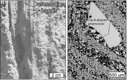
October 16, 2006 Article published in Journal of Geophysical Research An article titled, “Diagenesis of deformation band faults: Record and mechanical consequences of vadose zone flow and transport in the Bandelier Tuff, Los Alamos, New Mexico,” co-authored by Claudia Lewis (EES-9) appears in the September issue of the Journal of Geophysical Research. This research was funded by IGPP and constituted a key part of the NM Tech PhD thesis of Jennifer Wilson (EES-9). Lewis was a member of Wilson's thesis committee. Deformation bands are narrow fault zones, common in high-porosity materials like sand and sandstone, in which particles flow, grains are crushed, and pores collapse to accommodate mm- to cm-scale displacements (see Figure 1; DB=deformation band). Many of the deformation-band faults in Bandelier Tuff are locally rich in clay and/or cemented by carbonate. More than two thirds of the faults studied display minerals absent from the adjacent rock. Physical and chemical features of these fault zones indicate that they have served as zones of preferential near-surface fluid flow and transport. Alteration of the fault rock changes its permeability, affects transport of fluids, and changes the mechanical properties of the fault zone.
Figure 1. (a) Deformation bands in crystallized, nonwelded Bandelier Tuff. (b.) Backscattered electron image of deformation bands (DBs) in sample from Figure 1a. Deformation bands are characterized by crushed and-or aligned grains (gray) and collapsed pores (black). October 9, 2006 Field Expedition in México for Geologic Studies for High-Level Nuclear-Waste Repository The Peña Blanca Natural Analogue Project recently completed a successful field expedition to the study site in a remote area north of Chihuahua City, México. The project is a study of aqueous and particulate radionuclide migration at a former uranium mine. The ore body, surrounding rock, and groundwater system are being studied as a natural analogue for a high-level nuclear-waste repository in a geologic setting such as Yucca Mountain, Nevada. During the field expedition, groundwater-monitoring equipment was installed in three boreholes previously drilled for the project. Groundwater samples were collected for colloid analysis and seepage samples from an underground collection system were collected for chemical analysis. A special challenge was posed by the collection of short-lived radionuclides by pumping well water through manganese filters. Once the filtration was finished, the filters were put on a bus to Juarez, picked up and shipped from El Paso to the University of Southern California (USC) in Los Angeles. Shangde Luo of USC, who oversaw the filtration process, flew back to Los Angeles so that he could begin his analyses as soon as the filters arrived and before the radionuclides decayed to undetectable levels. Data from the study are used as input to a Yucca Mountain-type performance assessment numerical simulation. LANL project participants include Mike Murrell and Steve Goldstein of C-NR, John Dinsmoor and Alan Mitchell of EES-7, and Mable Amador of IRM-CAS. Other participants include Lawrence Berkeley National Laboratory, University of Southern California, University of Texas at El Paso, and AREVA (AREVA is a French nuclear power and electricity transmission group). The Instituto de Ecología and the Autonomous University of Chihuahua are collaborators on the project. This project is funded by DOE Office of Civilian Radioactive Waste Management, Office of Science and Technology and International and is managed by Schön Levy (EES-6). October 2, 2006 Western U.S. Geodynamics/CREST Workshop David Coblentz (EES-11) and Claudia Lewis (EES-9) organized the Western U.S. Geodynamics/CREST Workshop, held August 29 through September 1, 2006 in Aspen, Colorado. The workshop, funded through IGPP support, facilitated collaboration among LANL and university researchers working on the NSF-funded CREST (Colorado Rocky Mountain Experiment and Seismic Transect) project with the goal of understanding the interaction between dynamic lithospheric support, upper mantle structure and the evolution of topography. Attendees included faculty and students from eight universities. LANL scientist helps National Academy of Science review the US Climate Change Science Plan and link it to the Climate Change Technology Program Manvendra Dubey (EES-6) was part of a National Academy of Sciences (NAS) workshop to develop metrics for and assess progress in the 13-agency US Climate Change Science Plan (CCSP, $2 billion/year) led by NOAA and including DOE. Dubey was the only scientist from a DOE laboratory invited to this panel. Dubey coordinated his efforts with DOE's OBER program and LANL's program managers. The NAS committee, chaired by Prof. V. Ramanathan of UC-San Diego, hosted this meeting at the Scripps Institute of Oceanography. About 50 scientific leaders in climate and carbon cycle science were invited to this workshop. The attendees included senior NOAA leaders, including the former Asst. Secretary of Commerce and head of CCSP, Dr. Jim Mahoney and the interim head William Brennan, who spoke at the meeting. A NAS peer reviewed report will be delivered to the CCSP head and the CCSP leadership panel at the Deputy Secretary level. The discussions at the workshop highlighted the value of CCSP as a vehicle for effective leadership and coordination amongst agencies, and also pointed to linking CCSP to the DOE led multi-agency Climate Change Technology Program (CCTP). Dubey helped underscore the point that CCSP should consider CCTP as a customer and provide CO2 stabilization levels and time-lines to facilitate energy technology and carbon sequestration programs to mitigate risks for climate change. Because the new CCTP strategic plan has just been released, this is a very timely opportunity.
|
|