Projects
Taum Sauk Pumped Storage Project (No. P-2277), Dam Breach Incident
Project Description
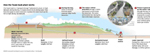
The Taum Sauk project is located in Reynolds County in south-eastern
Missouri, about 100 miles south of St. Louis. The project was
completed in 1963 as a pumped-storage project, with an upper and
a lower reservoir. The lower reservoir, operated as a run-of-river
reservoir with outflow being maintained at approximately equal
to natural inflow, provides storage for water to be pumped to
the upper reservoir at night or during periods of low power demand.
The water volume used to generate electricity is cycled between
the lower and upper reservoir, so the water elevations of the
lower and upper reservoirs fluctuate depending on the pumping/generating
modes of operation and time of day. The project structures include
a concrete faced rockfill dam (dike), that encircles and forms
the upper reservoir; a concrete gravity dam impounding the lower
reservoir (the lower dam was designed as a spillway with no spillway
gates so that flood waters could safety pass over the dam); a
reversible turbine powerhouse; a gravel trap dam located upstream
of the outlet canal in the lower reservoir, and a small dike that
impounds the seepage collection pond at the toe of the upper reservoir.
The Upper Reservoir is impounded by a kidney shaped rim dike at
the top of a planed-off mountain. The rockfill ring dike has a
reinforced concrete liner to reduce seepage through the rockfill
and has a maximum section approximately 94 feet high and is topped
by a 10 foot high concrete parapet wall. The reservoir bottom
has an asphaltic liner which ties into the concrete liner which
is on the inside slope of the rockfill dam. The surface area of
the reservoir is 54.5 acres with total storage of 4,350 acre-feet
and live storage of 2,560 acre-feet used for production of power.
The turbine/generator sets are designed to operate in reverse
to pump water to the upper reservoir at night. During the daylight
peak-demand hours, the turbine/generator sets operate in normal
gravity-feed mode to generate electricity.
The upper dam underwent maintenance work during the 2004 construction
season. The upstream face of the upper dam was lined with a geomembrane.
The purpose of this work was to minimize the leakage through the
rockfill dam. This work resulted in a significant decrease in
the amount of leakage from the upper reservoir.
FERC dam safety inspectors performed site inspections on December
14 and 15, 2005, where they made an immediate safety evaluation
of the lower dam. The lower dam was found to be safe following
the incident and had very little water flowing over it as of December
14. FERC will conduct a complete investigation of the rim dike
breach.
|
 |
 |
|
 |
| |
Contact Information
Public Inquiries
Telephone: 202-502-8004
Toll-free: 1-866-208-3372
TTY: 202-502-8659
Press Inquiries
Bryan Lee
Telephone: 202-502-8680
Email: bryan.lee@ferc.gov |
|
 |
|
 |
|