Local forecast by
"City, St" or zip code |
|
Search by city or zip code. Press enter or select the go button to submit request
|
| Rivers & Hydrology
|
 |
|
| Precip & Weather |
|
|
| Climate & History |
|
|
| Additional Info |
|
|
| About The LMRFC |
|
|
|
Hydrology and the National Weather
Service
There are 13 River Forecast Centers that are responsible for forecasting
the nations river systems and it's tributaries. Each River Forecast Center
is assigned a huge area of responsibility. Figure 1 shows the area of
coverage by each center. LMRFC - The Lower Mississippi River Forecast
Center's forecast area is in the lower right colored in red. This area
covers 209,310 square miles.

The following is a simplistic view of how to make a river stage forecast
by using the basic steps below:
- Data collection of stages, reservoir flows and mean area precipitation
and future rainfall.
- Data entry into the database.
- Data pre-processing - Quality control data to make sure figures
are correct.
- Input into a hydrologic model. This contains all pertinent information
at each forecast point, such as the present moisture in the top and
bottom layers of the soil, to the climatology of how it reacts to
rainfall.
The hydrologist is then able to obtain a forecast of the
discharge and then relate this to a stage. River stage forecasts are made
daily and is sent out to the Weather Service Forecast Offices. The River
Forecast Centers (RFC) make 3 day and also 5 day forecasts. Long range
forecast for 7 days and up to 30 days are made along the Mississippi weekly
by the LMRFC. When flooding is eminent, forecast are made for the time
and height of the crest of the stage and also when the river is expected
to go above flood stage. Another product sent out by the RFC's for use
by the Weather Offices is the Flash Flood Guidance. The Flash Flood Guidance
is and indicator of the amount of rainfall required to produce flooding.
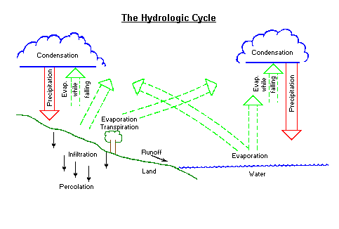
The Hydrologic Cycle
The hydrologic cycle is a very important scientific process. Without it,
there would not be precipitation (rain, snow, sleet, etc.). Without precipitation,
plant life would not grow and produce oxygen. And without oxygen, humans
could not live. Here's how the hydrologic process works:
- Water vapor enters the atmosphere by evaporation and transpiration.
Evaporation is the process of water (oceans, lakes, rivers, etc.)
changing into water vapor, while transpiration is the discharging
of water vapor into the atmosphere from living vegetation such as
leaves, grass, etc.
- Once water vapor enters the atmosphere, it rises and cools. As the
water vapor cools, condensation (change from water vapor into
liquid water) begins to form small drops of water. These small droplets
of water are what you look at when you see a cloud. As these droplets
bounce around and hit one another, they stick together and make larger
drops.
- When the drops of water become too heavy to be held up, they fall
back to the earth. Depending on the temperature, it can fall as rain,
snow, sleet, and many other forms of precipitation.
- Once the precipitation hits the ground, it begins to seep into the
ground. This process is called infiltration. But the soil can
hold only so much water. And when the ground becomes saturated, the
excess water drains into lakes, rivers, oceans, etc. This excess water
is called runoff. Then the hydrologic cycle starts all over again.
Note: The four major parts of the hydrologic cycle are in
bold face.
Questions
-
Name the four major parts of the hydrologic cycle.
-
What is the difference between evaporation and transpiration?
-
At what point would you start to get runoff?
The Hydrograph
A storm hydrograph is a graph of river stage or discharge at a gaging
site versus time. But before going into more detail of the hydrograph,
let's define some terms.
- Stage is the height or level of the water surface above a given
point at a particular location along the river.
- Discharge is the rate at which water passes a given point. Discharge
is expressed as cubic feet of water per second (cfs).
- Runoff is that part of the rainfall which travels over land into
various bodies of water.
A storm hydrograph is made up of two components...base flow
and surface runoff. Base flow is that rainfall which seeps (infiltrates)
into the soil and moves laterally to the stream channel, reaching the
stream channel after several days or more. Surface runoff consists of
the rainfall and/or snow melt which travels overland to the stream channel
plus rainfall directly deposited on the channel.
Figure 3 is an example of a storm hydrograph. 
This graphical display is a tool used by the Lower Mississippi River Forecast
Center to aid in river forecasting. Note the right vertical components
are in feet for the stage and the left vertical components are in cubic
feet per second for the discharge. The horizontal scale is time in six
hour increments. To the right of the dashed vertical line is future time.
Therefore the yellow 'o's are observed values of stage/discharge and the
magenta 'x's represent the estimate of future stage/discharge. The red
horizontal line represents flood stage. Note that the river is now in
flood. The blue stars are a simulation of the discharge.
At the top of the hydrograph, past and future rainfall is displayed along
with any existing runoff.
Surface runoff reaches the stream channel quickly and is the main contributor
of the total flow during flooding. Some main factors affecting runoff
are:
- Rainfall amount - High rainfall amounts produce more runoff
than low rainfall amounts.
- Rainfall intensity - For the same total amounts of rain,
more runoff will occur with rain falling in short periods of time
as opposed to rain falling in a longer period of time. For example,
one inch of rain falling in 30 minutes will produce more runoff than
one inch of rain falling in 24 hours. The lower runoff amounts are
due to the water having a longer time to seep (infiltrate) into the
ground.
- Soil type - More runoff will occur with clay soils while
sandy soils are able to absorb more rainfall.
- Soil moisture - When the top layer of soil is moist, there
will be more runoff then if the soil moisture content is low.
- Vegetation - Vegetative cover may slow the runoff from rainfall.
As vegetation takes-in water, the runoff is retarded.
- Topography - Runoff varies as the terrain varies. A mountainous
terrain will have a faster runoff rate than one of a flat terrain.
- State of ground - Rainfall over frozen ground produces more
runoff than rainfall over non-frozen ground. Frozen ground is more
impervious to rainfall.
Questions
-
What is a storm hydrograph?
-
What are the two components of a storm hydrograph?
-
Name 3 factors that affect runoff rates?
Flooding
Flooding kills more people and causes more damage per year on average
the any other natural disaster including hurricanes and tornadoes. There
are many different forms of flooding, but only the most common and most
destructive kinds will be covered. They are:
- Rainfall Flooding: This is the most common form of flooding.
When it rains enough to cause runoff, the runoff flows into the rivers
and the water levels begin to rise. The river will rise above its
banks and flood the surrounding area when more water than the river
can hold flows into it. This type of flooding can happen within less
than an hour after the rain begins (usually in mountainous regions)
or even days after the rain has stopped ( in flat regions). It can
also happen in a place where there was no rain at all! The rain can
fall over an area far upstream and be carried downstream, therefore
flooding areas where no rain had fallen.
- Snow Melt Flooding: This type of flooding usually occurs
in the north, but water from melted snow can influence river heights
all the way down to the Mississippi Delta. When temperatures begin
to rise in the spring and there is an excessive amount of snow on
the ground, the snow begins to melt and flow into the rivers. This
type of flooding is especially dangerous when temperatures rises well
above freezing (i.e., 50s and above) combined with additional rainfall.
- Ice Jam Flooding: This type of flooding only happens in cold
climates. Thick ice will form on the surface of rivers during periods
of continuous cold weather. When the water level rises quickly underneath
the ice, the ice will heave up, crack, and be carried down the river.
The large chunks of ice will then get stuck on a bridge or in a sharp
bend in the river. The ice will then block the flow of water and the
water will flow over its banks and flood the surrounding area. This
type of flooding is usually confined to smaller areas.
- Dam Break Flooding: This is usually the most destructive
type of flooding. Dams can hold back literally millions of gallons
of water which form huge man made lakes that can be used for many
things such as recreation (boating, swimming, fishing, etc), flood
management (holding excess water which would normally go down river
and flood), and city water management (holding water for people to
use for drinking, showering, etc). But when the dams are not constructed
or maintained correctly, it creates the potential for disaster. When
a weakened dam breaks, it sends a huge wall of water down the river
which can destroy entire towns in a matter of minutes. Fortunately,
this very destructive type of flooding is also the least common.
Questions
-
T - F Flooding only occurs when there is excessive
rain.
-
What is the most common form of flooding? The least
common?
Copy of paper in Word Perfect
form (graphics not included)
|