- Identification_Information:
-
- Citation:
-
- Citation_Information:
-
- Originator: U.S. Geological Survey (USGS), Coastal and Marine Geology (CMG)
- Publication_Date: 20090107
- Title:
-
Geological and Geophysical data of field activity F-4-91-CP
in Central Pacific from 03/27/1991 to 04/21/1991
- Publication_Information:
-
- Publisher: U.S. Geological Survey (USGS), Coastal and Marine Geology (CMG)
- Online_Linkage: <http://walrus.wr.usgs.gov/infobank/gos/f-4-91-cp.fmeta.xml>
- Online_Linkage:
-
<http://walrus.wr.usgs.gov/infobank/f/f491cp/html/f-4-91-cp.meta.html>
- Description:
-
- Abstract:
-
Korea Ocean Research and Development Institute (KORDI).
Chief Scientist: Mark Holmes. Geological and Geophysical data
(integratednavigation, GPS, LoranC, RhoRho, gravity,
magnetics, tempsalinometer, boxcore, gravitycore,
chaindredge, freefallgrab, 2channelairgun,
2channelairgunmonitor, 10khz, 3dot5khz, underwatercamera,
expendablebatthermograph, airgunmonitor) of field activity
F-4-91-CP in Central Pacific from 03/27/1991 to 04/21/1991,
<http://walrus.wr.usgs.gov/infobank/f/f491cp/html/f-4-91-cp.meta.html>.
- Purpose:
-
These data and information are intended for science
researchers, students from elementary through
college, policy makers, and general public.
- Supplemental_Information:
-
Equipment Used -
integratednavigation
GPS GPS satellite
LoranC
RhoRho Loran-C Rho-Rho
gravity
magnetics magnetometer
tempsalinometer temperature/salinity/conductance gauges
boxcore
gravitycore
chaindredge
freefallgrab
2channelairgun two-channel airgun
2channelairgunmonitor two-channel airgun monitor
10khz
3dot5khz
underwatercamera
expendablebatthermograph
airgunmonitor
Publications -
Chezar, Henry, and Newman, Ivy, 2004, DVD-Video Disc set of seafloor transects
during USGS research cruises in the Pacific Ocean, U.S. Geological Survey
Open-File Report OFR 2004-1137-A <BR>
<HR>
Chezar, Henry, and Newman, Ivy, 2004, DVD-Video Disc set of seafloor transects
during USGS research cruises in the Pacific Ocean, U.S. Geological Survey
Open-File Report OFR 2004-1137-B <BR>
<HR>
Chezar, Henry, and Newman, Ivy, 2004, DVD-Video Disc set of seafloor transects
during USGS research cruises in the Pacific Ocean, U.S. Geological Survey
Open-File Report OFR 2004-1137-C <BR>
<HR>
Chezar, Henry, and Newman, Ivy, 2004, DVD-Video Disc set of seafloor transects
during USGS research cruises in the Pacific Ocean, U.S. Geological Survey
Open-File Report OFR 2004-1137-D <BR>
<HR>
Chezar, Henry, and Newman, Ivy, 2004, DVD-Video Disc set of seafloor transects
during USGS research cruises in the Pacific Ocean, U.S. Geological Survey
Open-File Report OFR 2004-1137-E <BR>
Similar information is available for thousands
of other USGS/CMG-related Activities.
If known, available are Activity-specific
navigation, gravity, magnetics, bathymetry,
seismic, and sampling data; track maps; and
equipment information; as well as summary
overviews, crew lists, and information
about analog materials.
If available, access to physical samples is
described in the "WR CMG Sample Distribution
Policy" at:
<http://walrus.wr.usgs.gov/infobank/programs/html/main/sample-dist-policy.html>
Primary access to the USGS/CMG Information
Bank's digital data, analog data, and
metadata is provided through...
<http://walrus.wr.usgs.gov/infobank/>
This page accomodates a variety of search
approaches (e.g., by platform, by region,
by scientist, by equipment type, etc.).
- Time_Period_of_Content:
-
- Time_Period_Information:
-
- Range_of_Dates/Times:
-
- Beginning_Date: 19910327
- Ending_Date: 19910421
- Currentness_Reference: ground condition
- Status:
-
- Progress: Complete
- Maintenance_and_Update_Frequency: As needed
- Spatial_Domain:
-
- Bounding_Coordinates:
-
- West_Bounding_Coordinate: -157.90985
- East_Bounding_Coordinate: -139.07462
- North_Bounding_Coordinate: 21.26682
- South_Bounding_Coordinate: 13.30922
- Keywords:
-
- Theme:
-
- Theme_Keyword_Thesaurus: ISO 19115 Topic Category
- Theme_Keyword: geoscientificinformation
- Theme_Keyword: oceans
- Theme:
-
- Theme_Keyword_Thesaurus: USGS CMG InfoBank
- Theme_Keyword: Marine Geology
- Theme_Keyword: Marine Geophysics
- Theme_Keyword: Marine Gravity Field
- Theme_Keyword: Marine Magnetic Field
- Theme_Keyword: Magnetic Anomalies
- Theme_Keyword: Bathymetry
- Theme_Keyword: Water Depth
- Theme_Keyword: Seafloor Topography
- Theme_Keyword: Marine Seismic
- Theme_Keyword: Marine Metering
- Theme_Keyword: Temperature / Salinity / Conductance Gauges
- Theme_Keyword: Experimental Bathymetry Thermograph
- Place:
-
- Place_Keyword_Thesaurus: USGS CMG InfoBank
- Place_Keyword: Central Pacific
- Place_Keyword: Central Pacific Ocean
- Access_Constraints:
-
Physical materials are under controlled on-site access.
If available, access to physical samples is described
in the "WR CMG Sample Distribution Policy" at:
<http://walrus.wr.usgs.gov/infobank/programs/html/main/sample-dist-policy.html>
- Use_Constraints:
-
Please recognize the U.S. Geological Survey (USGS) as
the source of this information.
Physical materials are under controlled on-site access.
Some USGS information accessed through this means
may be preliminary in nature and presented without
the approval of the Director of the USGS. This
information is provided with the understanding
that it is not guaranteed to be correct or complete
and conclusions drawn from such information are
the responsibility of the user.
This information is not intended for navigational
purposes.
Any use of trade, firm, or product names is for
descriptive purposes only and does not imply
endorsement by the U.S. Government.
- Point_of_Contact:
-
- Contact_Information:
-
- Contact_Organization_Primary:
-
- Contact_Organization: U.S. Geological Survey (USGS), Coastal and Marine Geology (CMG)
- Contact_Person: Clint Steele
- Contact_Position: Data Acquisition, Processing, and Storage (DAPS) Group Leader
- Contact_Address:
-
- Address_Type: mailing and physical address
- Address: USGS, MailStop 999, 345 Middlefield Road
- City: Menlo Park
- State_or_Province: CA
- Postal_Code: 94025-3561
- Country: USA
- Contact_Voice_Telephone: (650) 329-5055
- Contact_Facsimile_Telephone: (650) 329-5190
- Contact_Electronic_Mail_Address: csteele@usgs.gov
- Browse_Graphic:
-
- Browse_Graphic_File_Name:
-
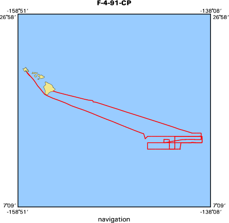
<http://walrus.wr.usgs.gov/infobank/f/f491cp/html/f-4-91-cp.nav.gif>
- Browse_Graphic_File_Description: Trackline map of F-4-91-CP
- Browse_Graphic_File_Type: GIF
- Browse_Graphic:
-
- Browse_Graphic_File_Name:
-
<http://walrus.wr.usgs.gov/infobank/f/f491cp/html/f-4-91-cp.grav.gif>
- Browse_Graphic_File_Description: Gravity data trackline map of F-4-91-CP
- Browse_Graphic_File_Type: GIF
- Browse_Graphic:
-
- Browse_Graphic_File_Name:
-
<http://walrus.wr.usgs.gov/infobank/f/f491cp/html/f-4-91-cp.mag.gif>
- Browse_Graphic_File_Description: Magnetics data trackline map of F-4-91-CP
- Browse_Graphic_File_Type: GIF
- Browse_Graphic:
-
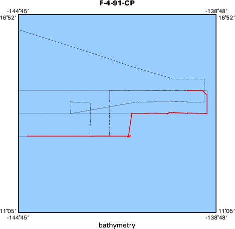
- Browse_Graphic_File_Name:
-
<http://walrus.wr.usgs.gov/infobank/f/f491cp/html/f-4-91-cp.bath.gif>
- Browse_Graphic_File_Description: Bathymetry data trackline map of F-4-91-CP
- Browse_Graphic_File_Type: GIF
- Browse_Graphic:
-
- Browse_Graphic_File_Name:
-
<http://walrus.wr.usgs.gov/infobank/f/f491cp/html/f-4-91-cp.samp.gif>
- Browse_Graphic_File_Description: Sampling locations map of F-4-91-CP
- Browse_Graphic_File_Type: GIF
- Data_Set_Credit:
-
John Nichols (Ship Captain);
Alex Hay (Chief Mate);
Mike Baldwin (Chief Engineer, USGS Western Region);
Mark Holmes (Chief Scientist, USGS Western Region);
Walt Olson (Mechanical Technician, USGS Western Region);
Hal Williams (Mechanical Technician, USGS Western Region);
Mike Boyle (Electronics Technician, USGS Western Region);
Jim Vaughan (Electrical Engineer, USGS Western Region);
Ledabeth Pickthorn (Navigator, USGS Western Region);
Kaye Kinoshita (Navigator, USGS Western Region);
Laura Zink (Watchstander, USGS Western Region);
Ray Silter (Watchstander, USGS Western Region);
Bill Weber (Watchstander, USGS Western Region);
Lisa Webber (Watchstander, USGS Western Region);
Jung-Keuk Kang (Chief Scientist, KORDI);
Dong-Hyeok Shin (Geologist, KORDI);
Sang-Bum Chi (Geologist, KORDI);
Suk-Hoon Yoon (Geologist, KORDI);
Su-Yeong Yang (Geophysicist, KORDI);
Dong-Jin Kang (Geochemist, KORDI);
Dong-Ill Lim (Geologist, KORDI);
Bum-Soo Kim (Geochemist, KORDI);
Cheong-Kee Park (Geologist, KORDI);
Sung-Sool Kang (Unspecified Investigator, KORDI);
Chang-Ryol Kim (Geophysicist, KORDI)
- Native_Data_Set_Environment: Digital, ASCII
- Cross_Reference:
-
- Citation_Information:
-
- Originator: U.S. Geological Survey (USGS), Coastal and Marine Geology (CMG)
- Publication_Date: Unknown
- Title: USGS/CMG Information Bank
- Publication_Information:
-
- Publisher: U.S. Geological Survey (USGS), Coastal and Marine Geology (CMG)
- Other_Citation_Details: Updated daily
- Online_Linkage: <http://walrus.wr.usgs.gov/infobank/>
- Other_Citation_Details:
-
Chezar, Henry, and Newman, Ivy, 2004, DVD-Video Disc set of seafloor transects
during USGS research cruises in the Pacific Ocean, U.S. Geological Survey
Open-File Report OFR 2004-1137-A
- Other_Citation_Details:
-
Chezar, Henry, and Newman, Ivy, 2004, DVD-Video Disc set of seafloor transects
during USGS research cruises in the Pacific Ocean, U.S. Geological Survey
Open-File Report OFR 2004-1137-B
- Other_Citation_Details:
-
Chezar, Henry, and Newman, Ivy, 2004, DVD-Video Disc set of seafloor transects
during USGS research cruises in the Pacific Ocean, U.S. Geological Survey
Open-File Report OFR 2004-1137-C
- Other_Citation_Details:
-
Chezar, Henry, and Newman, Ivy, 2004, DVD-Video Disc set of seafloor transects
during USGS research cruises in the Pacific Ocean, U.S. Geological Survey
Open-File Report OFR 2004-1137-D
- Other_Citation_Details:
-
Chezar, Henry, and Newman, Ivy, 2004, DVD-Video Disc set of seafloor transects
during USGS research cruises in the Pacific Ocean, U.S. Geological Survey
Open-File Report OFR 2004-1137-E
- Data_Quality_Information:
-
- Attribute_Accuracy:
-
- Attribute_Accuracy_Report: Identified as best available version.
- Logical_Consistency_Report: Unspecified
- Completeness_Report:
-
Start and end date/times of data
Navigation Data (f-4-91-cp.055 [SINS])
YYYYMMDDHHMMSST    YYYYMMDDHHMMSST
199103272307300    199104211504000
YYYYMMDDHHMMSST    YYYYMMDDHHMMSST
Gravity Data (f-4-91-cp.160_055)
YYYYMMDDHHMMSST    YYYYMMDDHHMMSST
199104050001200    199104090719000
YYYYMMDDHHMMSST    YYYYMMDDHHMMSST
Magnetics Data (f-4-91-cp.221_055)
YYYYMMDDHHMMSST    YYYYMMDDHHMMSST
199103280124000    199103280150000
199103280404400    199103280450000
199103280614000    199103280615200
199103280629200    199103310650000
199103310815400    199104060001400
YYYYMMDDHHMMSST    YYYYMMDDHHMMSST
Bathymetry Data (f-4-91-cp.351_055)
YYYYMMDDHHMMSST    YYYYMMDDHHMMSST
199104050006000    199104070354000
199104070406000    199104090724000
YYYYMMDDHHMMSST    YYYYMMDDHHMMSST
- Positional_Accuracy:
-
- Horizontal_Positional_Accuracy:
-
- Horizontal_Positional_Accuracy_Report: Unspecified
- Vertical_Positional_Accuracy:
-
- Vertical_Positional_Accuracy_Report: Unspecified
- Lineage:
-
- Process_Step:
-
- Process_Description:
-
Navigation Data
Converted to time format with year at start.
- Process_Date: 19960205
- Process_Contact:
-
- Contact_Information:
-
- Contact_Organization_Primary:
-
- Contact_Organization: U.S. Geological Survey (USGS), Coastal and Marine Geology (CMG)
- Contact_Person: Clint Steele
- Contact_Position: Data Acquisition, Processing, and Storage (DAPS) Group Leader
- Contact_Address:
-
- Address_Type: mailing and physical address
- Address: USGS, MailStop 999, 345 Middlefield Road
- City: Menlo Park
- State_or_Province: CA
- Postal_Code: 94025-3561
- Country: USA
- Contact_Voice_Telephone: (650) 329-5055
- Contact_Facsimile_Telephone: (650) 329-5190
- Contact_Electronic_Mail_Address: csteele@usgs.gov
- Process_Step:
-
- Process_Description:
-
Gravity Data
10/31/1998  /lion/f/f491cp/grav/f-4-91-cp.160_055
/bear/programs/edit/automerge/automerge

Input was...
Converted to time format with year at start.

02/14/92 CAROLYN PMG$PROC:[F491CP.G]F491CP.160;1
ISDMNL$DUA14:[PROGRAMS.][EDIT]SKIPNSAVE.EXE;1
Free Air Anomaly data

02/14/92 CAROLYN PMG$PROC:[F491CP.G]F491CPTT.130;1
ISDMNL$DUA14:[PROGRAMS.][FILT]TIPNTAIL.EXE;
Gravity SKIPNSAVE control data

02/14/92 CAROLYN PMG$PROC:[F491CP.G]F491CPGD.160;1
ISDMNL$DUA14:[PROGRAMS.][GRV]GRAVRED.EXE;4
Free Air Anomaly data

09/30/91 CAROLYN MARINE:[DATA.CRUISE.F491CP.WORK]F491CP.140;1
ISDMNL$DUA12:[PMG.REFMT]REFORMAT.EXE;
Land tie data calculated by KKinoshita:
086/1845 968768.88 Pier 28, Honolulu, HI
111/2000 968767.88 Pier 3, Hilo, HI

02/14/92 CAROLYN PMG$PROC:[F491CP.G]F491CPFILT.100;1
ISDMNL$DUA14:[PROGRAMS.][EDIT]SKIPNSAVE.EXE;1
Raw gravity data from digital meter

02/14/92 CAROLYN PMG$PROC:[F491CP.G]F491CPTT.130;1
ISDMNL$DUA14:[PROGRAMS.][FILT]TIPNTAIL.EXE;
Gravity SKIPNSAVE control data

02/14/92 CAROLYN PMG$PROC:[F491CP.G]F491CPET.100;1
ISDMNL$DUA14:[PROGRAMS.][NAV]EOTCSSP.EXE;1
Raw gravity data from digital meter

02/14/92 CAROLYN PMG$PROC:[F491CP.G]F491CP20SEC.100;1
ISDMNL$DUA14:[PROGRAMS.][EDIT]MERGEIT.EXE;
Raw gravity data from digital meter

02/14/92 CAROLYN PMG$PROC:[F491CP.G]F491CPTIMES.100;1
ISDMNL$DUA14:[PROGRAMS.][DSMPL]METAMUCIL.EXE;
Raw gravity data from digital meter

11/15/91 MHAMER MARINE:[DATA.CRUISE.F491CP.WORK.N]F491CP.085;1
ISDMNL$DUA12:[PMG.REFMT]DXFMT_TO_DAPS.EXE;1
Farnella ABC data
reformatted DXFMT file from the abc on the Farnella

11/15/91 MHAMER MARINE:[DATA.CRUISE.F491CP.WORK.N]F491CP.085;1
ISDMNL$DUA12:[PMG.REFMT]DXFMT_TO_DAPS.EXE;1
Farnella ABC data
reformatted DXFMT file from the abc on the Farnella

02/14/92 CAROLYN PMG$PROC:[F491CP.G]F491CPFT.100;1
ISDMNL$DUA14:[PROGRAMS.][FILT]FILTER.EXE;1
Raw gravity data from digital meter

02/14/92 CAROLYN PMG$PROC:[F491CP.G]F491CPTT.100;1
ISDMNL$DUA14:[PROGRAMS.][FILT]TIPNTAIL.EXE;
Raw gravity data from digital meter

02/14/92 CAROLYN PMG$PROC:[F491CP.G]F491CPET.100;1
ISDMNL$DUA14:[PROGRAMS.][NAV]EOTCSSP.EXE;1
Raw gravity data from digital meter

02/14/92 CAROLYN PMG$PROC:[F491CP.G]F491CP20SEC.100;1
ISDMNL$DUA14:[PROGRAMS.][EDIT]MERGEIT.EXE;
Raw gravity data from digital meter

02/14/92 CAROLYN PMG$PROC:[F491CP.G]F491CPTIMES.100;1
ISDMNL$DUA14:[PROGRAMS.][DSMPL]METAMUCIL.EXE;
Raw gravity data from digital meter

11/15/91 MHAMER MARINE:[DATA.CRUISE.F491CP.WORK.N]F491CP.085;1
ISDMNL$DUA12:[PMG.REFMT]DXFMT_TO_DAPS.EXE;1
Farnella ABC data
reformatted DXFMT file from the abc on the Farnella

11/15/91 MHAMER MARINE:[DATA.CRUISE.F491CP.WORK.N]F491CP.085;1
ISDMNL$DUA12:[PMG.REFMT]DXFMT_TO_DAPS.EXE;1
Farnella ABC data
reformatted DXFMT file from the abc on the Farnella

02/14/92 CAROLYN PMG$PROC:[F491CP.G]F491CPFILT.160;1
ISDMNL$DUA14:[PROGRAMS.][FILT]FILTER.EXE;1
Free Air Anomaly data

02/14/92 CAROLYN PMG$PROC:[F491CP.G]F491CPFT.160;1
ISDMNL$DUA14:[PROGRAMS.][FILT]FILTER.EXE;1
Free Air Anomaly data

02/14/92 CAROLYN PMG$PROC:[F491CP.G]F491CPTT.160;1
ISDMNL$DUA14:[PROGRAMS.][FILT]TIPNTAIL.EXE;
Free Air Anomaly data

02/14/92 CAROLYN PMG$PROC:[F491CP.G]F491CPGD.160;1
ISDMNL$DUA14:[PROGRAMS.][GRV]GRAVRED.EXE;4
Free Air Anomaly data

09/30/91 CAROLYN MARINE:[DATA.CRUISE.F491CP.WORK]F491CP.140;1
ISDMNL$DUA12:[PMG.REFMT]REFORMAT.EXE;
Land tie data calculated by KKinoshita:
086/1845 968768.88 Pier 28, Honolulu, HI
111/2000 968767.88 Pier 3, Hilo, HI

02/14/92 CAROLYN PMG$PROC:[F491CP.G]F491CPFILT.100;1
ISDMNL$DUA14:[PROGRAMS.][EDIT]SKIPNSAVE.EXE;1
Raw gravity data from digital meter

02/14/92 CAROLYN PMG$PROC:[F491CP.G]F491CPTT.130;1
ISDMNL$DUA14:[PROGRAMS.][FILT]TIPNTAIL.EXE;
Gravity SKIPNSAVE control data

02/14/92 CAROLYN PMG$PROC:[F491CP.G]F491CPET.100;1
ISDMNL$DUA14:[PROGRAMS.][NAV]EOTCSSP.EXE;1
Raw gravity data from digital meter

02/14/92 CAROLYN PMG$PROC:[F491CP.G]F491CP20SEC.100;1
ISDMNL$DUA14:[PROGRAMS.][EDIT]MERGEIT.EXE;
Raw gravity data from digital meter

02/14/92 CAROLYN PMG$PROC:[F491CP.G]F491CPTIMES.100;1
ISDMNL$DUA14:[PROGRAMS.][DSMPL]METAMUCIL.EXE;
Raw gravity data from digital meter

11/15/91 MHAMER MARINE:[DATA.CRUISE.F491CP.WORK.N]F491CP.085;1
ISDMNL$DUA12:[PMG.REFMT]DXFMT_TO_DAPS.EXE;1
Farnella ABC data
reformatted DXFMT file from the abc on the Farnella

11/15/91 MHAMER MARINE:[DATA.CRUISE.F491CP.WORK.N]F491CP.085;1
ISDMNL$DUA12:[PMG.REFMT]DXFMT_TO_DAPS.EXE;1
Farnella ABC data
reformatted DXFMT file from the abc on the Farnella

02/14/92 CAROLYN PMG$PROC:[F491CP.G]F491CPFT.100;1
ISDMNL$DUA14:[PROGRAMS.][FILT]FILTER.EXE;1
Raw gravity data from digital meter

02/14/92 CAROLYN PMG$PROC:[F491CP.G]F491CPTT.100;1
ISDMNL$DUA14:[PROGRAMS.][FILT]TIPNTAIL.EXE;
Raw gravity data from digital meter

02/14/92 CAROLYN PMG$PROC:[F491CP.G]F491CPET.100;1
ISDMNL$DUA14:[PROGRAMS.][NAV]EOTCSSP.EXE;1
Raw gravity data from digital meter

02/14/92 CAROLYN PMG$PROC:[F491CP.G]F491CP20SEC.100;1
ISDMNL$DUA14:[PROGRAMS.][EDIT]MERGEIT.EXE;
Raw gravity data from digital meter

02/14/92 CAROLYN PMG$PROC:[F491CP.G]F491CPTIMES.100;1
ISDMNL$DUA14:[PROGRAMS.][DSMPL]METAMUCIL.EXE;
Raw gravity data from digital meter

11/15/91 MHAMER MARINE:[DATA.CRUISE.F491CP.WORK.N]F491CP.085;1
ISDMNL$DUA12:[PMG.REFMT]DXFMT_TO_DAPS.EXE;1
Farnella ABC data
reformatted DXFMT file from the abc on the Farnella

11/15/91 MHAMER MARINE:[DATA.CRUISE.F491CP.WORK.N]F491CP.085;1
ISDMNL$DUA12:[PMG.REFMT]DXFMT_TO_DAPS.EXE;1
Farnella ABC data
reformatted DXFMT file from the abc on the Farnella

Input was...
Converted to time format with year at start.

time, lat, long, time(sec) to nearest nav fix, data values
- Process_Date: 19981031
- Process_Contact:
-
- Contact_Information:
-
- Contact_Organization_Primary:
-
- Contact_Organization: U.S. Geological Survey (USGS), Coastal and Marine Geology (CMG)
- Contact_Person: Clint Steele
- Contact_Position: Data Acquisition, Processing, and Storage (DAPS) Group Leader
- Contact_Address:
-
- Address_Type: mailing and physical address
- Address: USGS, MailStop 999, 345 Middlefield Road
- City: Menlo Park
- State_or_Province: CA
- Postal_Code: 94025-3561
- Country: USA
- Contact_Voice_Telephone: (650) 329-5055
- Contact_Facsimile_Telephone: (650) 329-5190
- Contact_Electronic_Mail_Address: csteele@usgs.gov
- Process_Step:
-
- Process_Description:
-
Magnetics Data
10/31/1998  /lion/f/f491cp/mag/f-4-91-cp.221_055
/bear/programs/edit/automerge/automerge

Input was...
Converted to time format with year at start.

02/19/92 CAROLYN PMG$PROC:[F491CP.M]F491CP.221;1
ISDMNL$DUA14:[PROGRAMS.][MAG]MAGRED.EXE;5
Edited magnetics data

02/19/92 CAROLYN PMG$PROC:[F491CP.M]F491CPFILT.202;1
ISDMNL$DUA14:[PROGRAMS.][EDIT]SKIPNSAVE.EXE;1
Raw magnetics data

02/19/92 CAROLYN PMG$PROC:[F491CP.M]F491CPTT.130;1
ISDMNL$DUA14:[PROGRAMS.][FILT]TIPNTAIL.EXE;
Gravity SKIPNSAVE control data

02/19/92 CAROLYN PMG$PROC:[F491CP.M]F491CP20SEC.202;1
ISDMNL$DUA14:[PROGRAMS.][EDIT]MERGEIT.EXE;
Raw magnetics data

02/19/92 CAROLYN PMG$PROC:[F491CP.M]F491CPTIMES.202;1
ISDMNL$DUA14:[PROGRAMS.][DSMPL]METAMUCIL.EXE;
Raw magnetics data

02/19/92 CAROLYN PMG$PROC:[F491CP.M]F491CPFT.202;1
ISDMNL$DUA14:[PROGRAMS.][FILT]FILTER.EXE;1
Raw magnetics data

02/19/92 CAROLYN PMG$PROC:[F491CP.M]F491CPTT.202;1
ISDMNL$DUA14:[PROGRAMS.][FILT]TIPNTAIL.EXE;
Raw magnetics data

02/19/92 CAROLYN PMG$PROC:[F491CP.M]F491CP20SEC.202;1
ISDMNL$DUA14:[PROGRAMS.][EDIT]MERGEIT.EXE;
Raw magnetics data

02/19/92 CAROLYN PMG$PROC:[F491CP.M]F491CPTIMES.202;1
ISDMNL$DUA14:[PROGRAMS.][DSMPL]METAMUCIL.EXE;
Raw magnetics data

11/15/91 MHAMER MARINE:[DATA.CRUISE.F491CP.WORK.N]F491CP.085;1
ISDMNL$DUA12:[PMG.REFMT]DXFMT_TO_DAPS.EXE;1
Farnella ABC data
reformatted DXFMT file from the abc on the Farnella

Input was...
Converted to time format with year at start.

time, lat, long, time(sec) to nearest nav fix, data values
- Process_Date: 19981031
- Process_Contact:
-
- Contact_Information:
-
- Contact_Organization_Primary:
-
- Contact_Organization: U.S. Geological Survey (USGS), Coastal and Marine Geology (CMG)
- Contact_Person: Clint Steele
- Contact_Position: Data Acquisition, Processing, and Storage (DAPS) Group Leader
- Contact_Address:
-
- Address_Type: mailing and physical address
- Address: USGS, MailStop 999, 345 Middlefield Road
- City: Menlo Park
- State_or_Province: CA
- Postal_Code: 94025-3561
- Country: USA
- Contact_Voice_Telephone: (650) 329-5055
- Contact_Facsimile_Telephone: (650) 329-5190
- Contact_Electronic_Mail_Address: csteele@usgs.gov
- Process_Step:
-
- Process_Description:
-
Bathymetry Data
10/31/1998  /lion/f/f491cp/bath/f-4-91-cp.351_055
/bear/programs/edit/automerge/automerge

Input was...
Converted to time format with year at start.

11/18/91 CDEGNAN MARINE:[DATA.CRUISE.F491CP.WORK.G]F491CP.351;1
ISDMNL$DUA12:[PMG.REFMT]DXFMT_TO_DAPS.EXE;1
Farnella corrected & edited bathymetry data
deleted records with zero bathy vals

11/15/91 MHAMER MARINE:[DATA.CRUISE.F491CP.WORK.N]F491CP.350;1
ISDMNL$DUA12:[PMG.REFMT]DXFMT_TO_DAPS.EXE;1
Farnella corrected & edited bathymetry data
bathymetry from a dxfmt tape off the abc on the Farnella

Input was...
Converted to time format with year at start.

time, lat, long, time(sec) to nearest nav fix, data values
- Process_Date: 19981031
- Process_Contact:
-
- Contact_Information:
-
- Contact_Organization_Primary:
-
- Contact_Organization: U.S. Geological Survey (USGS), Coastal and Marine Geology (CMG)
- Contact_Person: Clint Steele
- Contact_Position: Data Acquisition, Processing, and Storage (DAPS) Group Leader
- Contact_Address:
-
- Address_Type: mailing and physical address
- Address: USGS, MailStop 999, 345 Middlefield Road
- City: Menlo Park
- State_or_Province: CA
- Postal_Code: 94025-3561
- Country: USA
- Contact_Voice_Telephone: (650) 329-5055
- Contact_Facsimile_Telephone: (650) 329-5190
- Contact_Electronic_Mail_Address: csteele@usgs.gov
- Spatial_Data_Organization_Information:
-
- Indirect_Spatial_Reference: Central Pacific
- Direct_Spatial_Reference_Method: Point
- Point_and_Vector_Object_Information:
-
- SDTS_Terms_Description:
-
- SDTS_Point_and_Vector_Object_Type: Point
- Spatial_Reference_Information:
-
- Horizontal_Coordinate_System_Definition:
-
- Geographic:
-
- Latitude_Resolution: 0.00001
- Longitude_Resolution: 0.00001
- Geographic_Coordinate_Units: Decimal degrees
- Geodetic_Model:
-
- Horizontal_Datum_Name: North American Datum of 1983
- Ellipsoid_Name: Geodetic Reference System 80
- Semi-major_Axis: 6378137
- Denominator_of_Flattening_Ratio: 298.257
- Vertical_Coordinate_System_Definition:
-
- Depth_System_Definition:
-
- Depth_Datum_Name: Local surface
- Depth_Resolution: 0.1
- Depth_Distance_Units: meters
- Depth_Encoding_Method: Attribute values
- Entity_and_Attribute_Information:
-
- Overview_Description:
-
- Entity_and_Attribute_Overview: Bathymetry with Time Stamp
- Entity_and_Attribute_Detail_Citation:
-
Farnella corrected & edited bathymetry data
Mnemonic:       (Year, Day, Hour, Min, Sec, Tenths, Depth)
FORTRAN format: (i4.4, i3.3, 3i2.2, i1.1, t16, f7.1)
C format:       (%4.4i%3.3i3%2.2i%1.1i %7.1f\\n)
Naming:         .350
- Overview_Description:
-
- Entity_and_Attribute_Overview: Gravity with Time Stamp
- Entity_and_Attribute_Detail_Citation:
-
Free Air Anomaly data
Mnemonic:       (Year, Day, Hour, Min, Sec, Tenths, Eotvos, ObsGrv, TheoGrv, FAA)
FORTRAN format: (i4.4, i3.3, 3i2.2, i1.1, t16, f6.1, t23, f9.1, t33, f9.1, t43, f8.1)
C format:       (%4.4i%3.3i3%2.2i%1.1i %6.1f %9.1f %9.1f %8.1f\\n)
Naming:         .160
- Overview_Description:
-
- Entity_and_Attribute_Overview: Magnetics with Time Stamp
- Entity_and_Attribute_Detail_Citation:
-
Edited magnetics data
Mnemonic:       (Year, Day, Hour, Min, Sec, Tenths, MstObs, MstReg, MstRes)
FORTRAN format: (i4.4, i3.3, 3i2.2, i1.1, t16, f7.1, t24, f7.1, t32, f7.1)
C format:       (%4.4i%3.3i3%2.2i%1.1i %7.1f %7.1f %7.1f\\n)
Naming:         .220
- Overview_Description:
-
- Entity_and_Attribute_Overview: Navigation with Time Stamp
- Entity_and_Attribute_Detail_Citation:
-
Integrated navigation (SINS) data
Mnemonic:       (Year, Day, Hour, Min, Sec, Tenths, Latitude, Longitude)
FORTRAN format: (i4.4, i3.3, 3i2.2, i1.1, t16, f9.5, t26, f10.5)
C format:       (%4.4i%3.3i3%2.2i%1.1i %9.5f %10.5f\\n)
Naming:         .050
- Distribution_Information:
-
- Distributor:
-
- Contact_Information:
-
- Contact_Organization_Primary:
-
- Contact_Organization: U.S. Geological Survey (USGS), Coastal and Marine Geology (CMG)
- Contact_Person: Clint Steele
- Contact_Position: Data Acquisition, Processing, and Storage (DAPS) Group Leader
- Contact_Address:
-
- Address_Type: mailing and physical address
- Address: USGS, MailStop 999, 345 Middlefield Road
- City: Menlo Park
- State_or_Province: CA
- Postal_Code: 94025-3561
- Country: USA
- Contact_Voice_Telephone: (650) 329-5055
- Contact_Facsimile_Telephone: (650) 329-5190
- Contact_Electronic_Mail_Address: csteele@usgs.gov
- Resource_Description: Downloadable Data F-4-91-CP data set
- Distribution_Liability:
-
Please recognize the U.S. Geological Survey (USGS) as
the source of this information.
Physical materials are under controlled on-site access.
Some USGS information accessed through this means
may be preliminary in nature and presented without
the approval of the Director of the USGS. This
information is provided with the understanding
that it is not guaranteed to be correct or complete
and conclusions drawn from such information are
the responsibility of the user.
This information is not intended for navigational
purposes.
Any use of trade, firm, or product names is for
descriptive purposes only and does not imply
endorsement by the U.S. Government.
- Standard_Order_Process:
-
- Digital_Form:
-
- Digital_Transfer_Information:
-
- Format_Name: ASCII
- File_Decompression_Technique: No compression applied
- Transfer_Size: 1.3
- Digital_Transfer_Option:
-
- Online_Option:
-
- Computer_Contact_Information:
-
- Network_Address:
-
- Network_Resource_Name:
-
<http://walrus.wr.usgs.gov/infobank/f/f491cp/html/f-4-91-cp.nav.html>
- Digital_Form:
-
- Digital_Transfer_Information:
-
- Format_Name: ASCII
- File_Decompression_Technique: No compression applied
- Transfer_Size: 1.6
- Digital_Transfer_Option:
-
- Online_Option:
-
- Computer_Contact_Information:
-
- Network_Address:
-
- Network_Resource_Name:
-
<http://walrus.wr.usgs.gov/infobank/f/f491cp/html/f-4-91-cp.grav.html>
- Digital_Form:
-
- Digital_Transfer_Information:
-
- Format_Name: ASCII
- File_Decompression_Technique: No compression applied
- Transfer_Size: 2.7
- Digital_Transfer_Option:
-
- Online_Option:
-
- Computer_Contact_Information:
-
- Network_Address:
-
- Network_Resource_Name:
-
<http://walrus.wr.usgs.gov/infobank/f/f491cp/html/f-4-91-cp.mag.html>
- Digital_Form:
-
- Digital_Transfer_Information:
-
- Format_Name: ASCII
- File_Decompression_Technique: No compression applied
- Transfer_Size: 0.1
- Digital_Transfer_Option:
-
- Online_Option:
-
- Computer_Contact_Information:
-
- Network_Address:
-
- Network_Resource_Name:
-
<http://walrus.wr.usgs.gov/infobank/f/f491cp/html/f-4-91-cp.bath.html>
- Fees: None
- Metadata_Reference_Information:
-
- Metadata_Date: 20090107
- Metadata_Contact:
-
- Contact_Information:
-
- Contact_Organization_Primary:
-
- Contact_Organization: U.S. Geological Survey (USGS), Coastal and Marine Geology (CMG)
- Contact_Person: Clint Steele
- Contact_Position: Data Acquisition, Processing, and Storage (DAPS) Group Leader
- Contact_Address:
-
- Address_Type: mailing and physical address
- Address: USGS, MailStop 999, 345 Middlefield Road
- City: Menlo Park
- State_or_Province: CA
- Postal_Code: 94025-3561
- Country: USA
- Contact_Voice_Telephone: (650) 329-5055
- Contact_Facsimile_Telephone: (650) 329-5190
- Contact_Electronic_Mail_Address: csteele@usgs.gov
- Metadata_Standard_Name: FGDC Content Standards for Digital Geospatial Metadata
- Metadata_Standard_Version: FGDC-STD-001-1998
- Metadata_Time_Convention: universal time
- Metadata_Access_Constraints: none
- Metadata_Use_Constraints: none
|


