(M) Map of the Battle of Gettysburg |
|
|---|---|
 Click on image to enlarge |
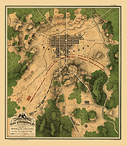
Map of the battle of Gettysburg, Pa., July 1st, 2nd & 3rd, 1863, showing line of battle on P.M. of 2nd Prepared by Wm. H. Willcox, Captn. & A.D.C. on Maj. Genl. Reynold's staff. 3d ed. Lith of P. S. Duval & Son, Philada. J. G. Shoemaker, engr. Created/Published : S.l., 1863 Notes : Scale ca. 1:13,100. Shows topography by hachures, vegetation, drainage, roads, railroads, houses, stonewalls, cultivated areas, churches, and cemeteries. Union and Confederate positions are shown, including the location of the artillery. Confederate corps are named; Union forces are given in more detail, including names of some division commanders. Shows the Union breast works and cavalry positions. Description derived from published bibliography. Housed in the Geography and Maps Division of the Library of Congress Availability: Usually ships in 1-2 weeks. Product #: mapofbaofge1 |
|
Go Back |
|