|
North Pole Weather
Data from 2002 Deployment
In April 2002, PMEL deployed instrumentation and one web cam on
an ice floe at the North Pole. The 2002
web cam failed when winter cold
and darkness fell over the North Pole in September 2002. The ice
floe continued to drift and the 2002 instrumentation is still transmitting data, which is
shown
on this page. Note that new instrumentation and two
new Web Cams were deployed at the North Pole, on a different ice floe, in April
2003. Data from the 2003 instrumentation is available on North
Pole Weather Data from 2003 Deployment.
Weather data plot
Ice-temperature plot
Map of station drift
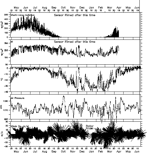
Weather plot: This
plot presents incoming short-wave solar radiation measured by one
of the radiometer buoys,
along with air temperature, air pressure, and winds measured by
the meteorological station.

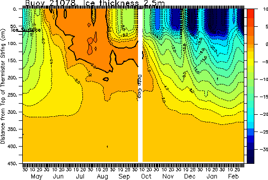
Ice-temperature plot: Plot of air, ice,
and ocean temperature as measured by one of the PMEL/CRREL Mass
Balance Buoys. One of these buoys is visible just
to the right of the weather station. Initially, a little more
than 50 cm of the thermistor string was above the ice, and about
160
cm of the thermistor string was in the water. (This buoy is no longer
transmitting. The last data received are from March 1, 2003.)
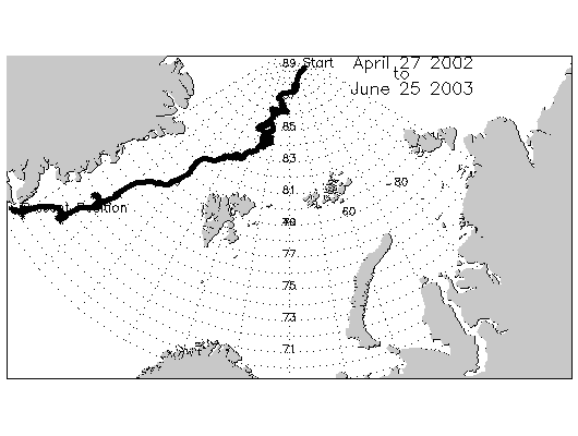
Map of station drift: Drift
of the North Pole station since its deployment near 88.5
N in late April 2002. Station location is derived from the Global
Positioning System (GPS). (The weather station stopped transmitting
on June 25, 2003 when its floe was crushed or melted off eastern
Greenland.)
Click here to calculate sunrise/sunset times for any location on the earth.
More Information :
|