| Products We Issue... | |||
| Below you will find a comprehensive listing
of the
products we issue here at the National Weather Service Office in Jackson, KY, and a brief description and issuance criteria for the
products. As always, if you have any comments or questions about the products we issue, drop our Webmaster an email. |
| Graphical Forecast Products | |||
| Product | Example | Description | |
|
National Digital Forecast Database (NDFD) |  |
WFO Jackson provides detailed graphics of several forecast elements to the National Digital Forecast Database, such as hourly temperature, high temperatures, low temperatures, wind speed and direction, precipitation, and sky cover to name a few. All of the individual forecast office graphics are combined into images, scaleable down to the regional level. | |
|
Local Graphics | 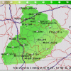 |
The same graphics that are provided in the NDFD are provided in high resolution PNG images. | |
|
Hourly Weather Graph |  |
The following weather elements are presented in a linear format for a user-selectable location, tracing the changes on an hourly basis: Temperature, Dewpoint, Relative Humidity, Sky Cover, Wind Chill (seasonal), Heat Index (seasonal), Wind Direction/Speed, Probability of Precipitation. Ceiling Height and Visibility are also presented on an experimental basis. The following weather elements are presented in bar graph format, giving the chances for each type of weather event categorically: Rain, Thunder, Snow, and Freezing Rain. | |
|
Digital Tabular |  |
Forecast information provided for a user-selectable location in tabular format for the next 72 hours. The user can select which weather elements they would like to see the forecast for by selecting/de-selecting the weather element check boxes. The following elements are presented in a tabular format on an hourly basis: Temperature, Dewpoint, Relative Humidity, Sky Cover, Wind Chill (seasonal), Heat Index (seasonal), Wind Direction/Speed, Probability of Precipitation, Rain, Thunder, Snow (seasonal), Freezing Rain (seasonal). | |
|
Weather Activity Planner |  |
By entering the range of weather parameters required for your activity and then, either clicking the approximate location on the map below, or entering the specific latitude and longitude, this program will find when your weather requirements will be met at the nearest grid point over the next 7 days. | |
|
Digital Forecast |  |
Retrieve a spatially averaged area forecast for a user defined county or for several locations across eastern Kentucky in a graphical, easy to understand format. | |
|
Graphicast - Today's Weather Story | 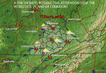 |
A graphical depiction of the top weather story of the day. | |
|
Graphical Short Term Forecast - Experimental |  |
Graphical depiction of the weather forecast for the next couple of hours. | |
| Routine Public Forecast Text Products | |||
| Product | Availability | Description | |
|
Regional Weather Summary WMO Header: AWUS83 KJKL AWIPS Header: SDFRWSJKL |
3:30 PM Mon Sep 22nd 2008 newest 2 3 4 5 6 7 8 9 10 |
Issued twice daily around 4 AM/PM, providing a brief weather summary and forecast for our local forecast area. | |
|
Zone Forecast Product WMO Header: FPUS53 KJKL AWIPS Header: SDFZFPJKL |
3:15 PM Mon Sep 22nd 2008 newest 2 3 4 5 6 7 8 9 10 |
A county-by-county forecast written in plain text for the next 7 days. Includes any long-term watches, warnings, and advisories. | |
|
Area Forecast Discussion WMO Header: FXUS63 KJKL AWIPS Header: SDFAFDJKL |
3:29 AM Tue Sep 23rd 2008 newest 2 3 4 5 6 7 8 9 10 |
A technical discussion of the meteorological reasoning behind the forecast. | |
|
Hazardous Weather Outlook WMO Header: FLUS43 KJKL AWIPS Header: SDFHWOJKL |
5:32 AM Mon Sep 22nd 2008 newest 2 3 4 5 6 7 8 9 10 |
Used for communicating the potential for hazardous weather, and preparedness for spotter activation. | |
|
Point Forecast Matrices WMO Header: FOUS53 KJKL AWIPS Header: SDFPFMJKL |
9:35 PM Mon Sep 22nd 2008 newest 2 3 4 |
Point forecasts for selected locations that covers the next 7 days in matrix format. | |
|
Area Forecast Matrices WMO Header: FOUS53 KJKL AWIPS Header: SDFAFMJKL |
9:33 PM Mon Sep 22nd 2008 newest 2 3 4 |
An area averaged forecast for the next 7 days in matrix format. | |
|
Coded Cities Forecast WMO Header: FPUS43 KJKL AWIPS Header: SDFCCFJKL |
3:20 PM Mon Sep 22nd 2008 newest 2 3 4 5 6 7 8 9 10 |
A coded forecast for select cities in our forecast area. Information includes high and low temperatures, and 12-hour probability of precipitation. | |
| Event-Driven Hazardous Weather Text Products | |||
| Product | Availability | Description | |
|
Short Term Forecast WMO Header: FPUS73 KJKL AWIPS Header: SDFNOWJKL |
7:41 PM Sun Sep 21st 2008 newest 2 3 4 5 6 7 8 9 10 |
An overview of weather trends during the next 1 to 6 hours. Normally issued only when precipitation or hazardous weather is occurring. | |
|
Special Weather Statement WMO Header: WWUS83 KJKL AWIPS Header: SDFSPSJKL |
5:52 PM Sat Sep 20th 2008 newest |
Product issued to provide information on upcoming hazardous weather events or near term events that, while not severe, may cause inconveniences to public and other interests. | |
|
Watch County Notification WMO Header: WWUS63 KJKL AWIPS Header: SDFWCNJKL |
Product lists counties in the Jackson Forecast Area included in Severe Thunderstorm or Tornado Watches. This product also communicates removal of counties and cancellation/expiration of watches. | ||
|
Tornado Warning WMO Header: WFUS53 KJKL AWIPS Header: SDFTORJKL |
Typically issued for single counties or a small group of adjacent counties for 15 to 45
minutes in
duration. Criteria for Issuance: Issued when a tornado is sighted or indicated by National Weather Service Radar. |
||
|
Severe Thunderstorm Warning WMO Header: WUUS53 KJKL AWIPS Header: SDFSVRJKL |
Issued when a severe thunderstorm is imminent or occurring. Typically issued for single
counties or a small
group of adjacent counties for 15 to 60 minutes in duration. Criteria for Issuance: A thunderstorm is considered severe when it contains winds of 58 mph or greater and/or hail 3/4" in diameter or larger. |
||
|
Severe Weather Statement WMO Header: WWUS53 KJKL AWIPS Header: SDFSVSJKL |
Issued as a follow-up to severe weather warnings. Used to relay urgent information about ongoing severe weather, such as damage reports and up-to-the-minute storm location updates. Also used to cancel or expire severe weather warnings. | ||
|
Hydrologic Outlook WMO Header: FGUS73 KJKL AWIPS Header: SDFESFJKL |
9:04 PM Sat Aug 23rd 2008 newest |
Issued when conditions appear favorable for possible flooding from 36 hours and beyond in the future. Drought statements are also issued using this product when conditions warrant. | |
|
Flood Watch WMO Header: WGUS63 KJKL AWIPS Header: SDFFFAJKL |
Issued when conditions are favorable for flooding during the next 36 hours. | ||
|
Flash Flood Warning WMO Header: WGUS53 KJKL AWIPS Header: SDFFFWJKL |
Issued when flash flooding is imminent or occurring. Typically issued for single counties
or a small
group of adjacent counties for 2 to 6 hours in duration. Criteria for Issuance: Flash flooding occurs when water levels rise rapidly to inundation within a period of 6 hours of the causative event. The flood waters must be 6 inches deep when flowing or 3 feet deep when standing to qualify for a flash flood event. |
||
|
Flood Warning WMO Header: WGUS43 KJKL AWIPS Header: SDFFLWJKL |
Issued when river levels are expected to rise to potentially damaging levels. Flood
Warnings can also
be used when overland flooding is expected to persist for many hours. Criteria for Issuance: Flood Warnings are issued when flooding is expected to occur more than 6 hours after the causative event and are issued for river forecast points, areas along rivers and streams and for counties or portions of counties. |
||
|
Flash Flood Statement WMO Header: WGUS73 KJKL AWIPS Header: SDFFFSJKL |
Issued as a follow-up to Flash Flood Warnings and contains the latest flooding reports and radar trends. | ||
|
Flood Statement WMO Header: WGUS83 KJKL AWIPS Header: SDFFLSJKL |
8:07 PM Sat Sep 20th 2008 newest 2 3 |
Flood statements may be issued as a follow-up to Flood Warnings, Flood Watches, or for high water in urban areas and along small streams (formerly the Urban and Small Stream Flood Advisory). | |
|
Winter Weather Product WMO Header: WWUS43 KJKL AWIPS Header: SDFWSWJKL |
Provides watches, warnings, and advisories for winter precipitation events. Criteria for Issuance: Snow Advisory: Issued for snow accumulations more than 1 inch but less than 4 inches. Blowing Snow Advisory: Issued for localized blowing snow reducing visibilities to 1/4 mile or less with winds less than 35 mph. Snow and Blowing Snow Advisory: Same criteria as Blowing Snow Advisory, except snow is falling in addition to blowing around. Freezing Rain Advisory: Ice accumulation less than 1/4 of an inch with rain or drizzle freezing on contact. Sleet Advisory: Sleet accumulation of less than 1/2 of an inch. Wind Chill Advisory: Wind chills of 10 below to 24 below are expected. In most cases a minimum wind speed of 10 mph or more should be occurring or forecast before an advisory is issued. Winter Weather Advisory: Issued when more than one predominant type of hazard is expected, one of which must meet advisory criteria described above. Heavy Snow Warning: Snow accumulation is expected to be 4 inches in 12 hours, or 6 inches in 24 hours. Ice Storm Warning: Ice accumulation of 1/4 inch or more. Heavy Sleet Warning: Sleet accumulation of 1/2 inch or more. Wind Chill Warning: Wind chills of 25 below or colder are expected. In most cases a minimum wind speed of 10 mph should be occurring or forecast before a warning is issued. Winter Storm Warning: More than one predominant hazard is expected, one of which must meet warning criteria described above. Blizzard Warning: Sustained wind or frequent gusts greater than or equal to 35 mph is/are expected, accompanied by falling and/or blowing snow, frequently reducing visibility to less than 1/4 mile for three hours or more. |
||
|
Non Precipitation Product WMO Header: WWUS73 KJKL AWIPS Header: SDFNPWJKL |
Provides watches, warnings, or advisories issued for a wide variety of hazardous weather
phenomena, such as
high winds, dense fog, extreme heat, or low wind chills. Criteria for Issuance: Wind Advisory: Sustained speeds between 30 and 39 mph for at least one hour, or wind gusts of 45 to 57 mph for any duration. Advisories are used for winds not associated with thunderstorms. Lake Wind Advisory: Sustained speeds between 20 and 29 mph for at least one hour, or wind gusts of 35 to 44 mph for any duration. Lake Wind Advisories are used for winds not associated with thunderstorms and only from April 1 to October 30. Dense Fog Advisory: Fog reducing visibility to 1/4 mile or less over a widespread area. Heat Advisory: Heat index of 105 or higher for at least 3 hours or more with a minimum heat index around 75 during a 24 hour period. Frost Advisory: Issued only during the growing season when widespread frost is expected with temperatures remaining above freezing. Smoke Advisory: Smoke reducing visibility to 1/4 mile or less over a widespread area. Blowing Dust Advisory: Visibility is greater than 1/4 mile, but less than one mile in blowing dust. High Wind Warning: Issued for sustained speeds of at least 40 mph for an hour or more, or wind gusts of at least 58 mph regardless of duration. A High Wind Warning is used for winds not associated with thunderstorms. Excessive Heat Warning: Issued when the Heat Index is expected to be at least 110 for 3 hours or more with a minimum heat index around 75 during a 24 hour period. Freeze Warning: Issued when temperatures are forecast to be 32 degrees or less over a widespread area during the growing season. Blowing Dust: Issued when visibilities are 1/4 mile or less due to blowing dust. |
||
|
Local Storm Report WMO Header: NWUS53 KJKL AWIPS Header: SDFLSRJKL |
Used to disseminate weather information. Includes the time and date of the event, its location, and any other pertinent information. | ||
| Fire Weather Text Products | |||
| Product | Availability | Description | |
|
Fire Weather Forecast WMO Header: FNUS53 KJKL AWIPS Header: SDFFWFJKL |
6:15 AM Mon Sep 22nd 2008 newest 2 3 |
Issued twice daily during the Fire Season (Feb 1st thru May 15th and Oct 1st thru Dec 15th) and once daily otherwise. Contains weather elements of critical importance to fire managers, such as relative humidity, precipitation duration and amounts, smoke mixing heights, and transport winds. | |
|
Fire Weather Point Forecast WMO Header: FNUS83 KJKL AWIPS Header: SDFFWMJKL |
3:03 PM Thu Sep 18th 2008 newest |
Issued daily during the fire season. Contains a coded forecast of weather elements critical to fire behavior for specific forest sites in our fire weather forecast area. | |
|
Fire Weather Watch/Red Flag Warning WMO Header: WWUS83 KJKL AWIPS Header: SDFRFWJKL |
Issued when extreme burning conditions are forecast. Criteria for Issuance: Red Flag conditions are defined in eastern Kentucky as 1) Sustained 20-foot wind speeds of 15 mph or greater, 2) Minimum relative humidity of 25% or less, 3) and 10-hour fuel moisture values of 8% or less. |
||
| Aviation Text Products | |||
| Product | Availability | Description | |
| Terminal Aerodrome
Forecast WMO Header: FTUS43 KJKL AWIPS Header: SDFTAFJKL - JKL SDFTAFLOZ - LOZ SDFTAFSME - SME |
1:20 AM Tue Sep 23rd 2008 newest 2 3 4 5 6 7 8 9 10 1:20 AM Tue Sep 23rd 2008 newest 2 3 4 5 6 7 8 9 10 1:20 AM Tue Sep 23rd 2008 newest 2 3 4 5 6 7 8 9 10 |
An aviation forecast containing METAR-coded forecast data for a designated airport and its immediate vicinity. Valid for 24 hours in duration, issued 4 times daily. | |
| Routine Hydrologic Text Products | |||
| Product | Availability | Description | |
|
Hydrologic Summary WMO Header: SRUS43 KJKL AWIPS Header: SDFRVAJKL |
9:59 AM Mon Sep 22nd 2008 newest 2 3 |
Issued daily around 10 AM LST. Contains observed river stages and precipitation reports. | |
|
River and Lake Summary WMO Header: FGUS53 KJKL AWIPS Header: SDFRVDJKL |
9:45 AM Mon Sep 22nd 2008 newest |
Issued daily around 10 AM LST. Contains a 3 day river stage forecast for select locations in our hydrologic service area. | |
| Climate Text Products | |||
| Product | Availability | Description | |
| Daily Climate Summary WMO Header: CDUS43 KJKL AWIPS Header: SDFCLIJKL - Jackson SDFCLILOZ - London |
1:36 AM Tue Sep 23rd 2008 newest 2 3 4 5 6 7 8 9 10 1:38 AM Tue Sep 23rd 2008 newest 2 3 4 5 6 7 8 9 10 |
Issued around 1 AM LST and 4 PM LST each day. Contains climatological observed values, along with normals, records, and monthly, seasonal, and yearly accumulations. | |
| Preliminary Local Climate
Data WMO Header: CXUS55 KJKL AWIPS Header: SDFCF6JKL - Jackson SDFCF6LOZ - London |
7:11 AM Tue Sep 30th 2008 newest 2 3 4 5 6 7 8 9 10 7:11 AM Tue Sep 30th 2008 newest 2 3 4 5 6 7 8 9 10 |
A summary of the daily climate statistics for the current month for a location, updated daily. | |
| Monthly Climate Summary WMO Header: CXUS53 KJKL AWIPS Header: SDFCLMJKL - Jackson SDFCLMLOZ - London |
3:26 AM Mon Sep 1st 2008 newest 2 3 4 5 6 7 8 9 10 3:24 AM Mon Sep 1st 2008 newest 2 3 4 5 6 7 8 |
Contains climatological observed values for the previous month, along with normals, records, and monthly, seasonal, and yearly accumulations. | |
| Seasonal Climate Summary WMO Header: CXUS53 KJKL AWIPS Header: SDFCLSJKL - Jackson SDFCLSLOZ - London |
11:42 AM Wed Sep 10th 2008 newest 2 3 4 5 11:35 AM Wed Sep 10th 2008 newest 2 3 |
Contains climatological observed values for the meteorological season. The meteorological seasons are defined as follows; Winter- December through February, Spring- March through May, Summer- June through August, Fall- September through November. | |
| Record Event Report WMO Header: SXUS73 KJKL AWIPS Header: SDFRERJKL - Jackson SDFRERLOZ - London |
11:31 PM Sat Sep 13th 2008 newest 2 3 4 5 6 7 8 9 10 3:56 AM Sat Sep 13th 2008 newest 2 3 4 5 6 7 8 9 10 |
Issued when a daily or monthly temperature or precipitation record has been tied or broken. | |
|
Regional Temperature & Precipitation Summary WMO Header: ASUS63 KJKL AWIPS Header: SDFRTPJKL |
8:34 PM Mon Sep 22nd 2008 newest 2 3 4 5 6 7 8 9 10 |
Details maximum and minimum temperature along with 24 hour precipitation for select locations within our forecast area. | |
|
Supplemental Climate Data WMO Header: CXUS63 KJKL AWIPS Header: SDFSCDJKL |
1:00 AM Tue Sep 23rd 2008 newest 2 3 4 5 6 7 8 9 10 |
A coded message sent at the 6 hour synoptic times (00 UTC, 06 UTC, 12 UTC, 18 UTC), around 08 UTC (for sunshine minutes only) and local midnight. The message includes details on cloud cover, precip measurements, snowfall measurements and sunshine minutes observed at the Jackson, KY Weather Forecast Office. | |
|
Supplemental Data Observation WMO Header: CXUS53 KJKL AWIPS Header: SDFSDOJKL |
A coded message sent only when certain weather events are observed at the Jackson, KY Weather Forecast Office, such as hail or ice pellets. | ||
| Miscellaneous Text Products | |||
| Product | Availability | Description | |
|
Hourly Weather Summary WMO Header: ASUS43 KJKL AWIPS Header: SDFRWRJKL |
3:19 AM Tue Sep 23rd 2008 newest 2 3 4 5 6 7 8 9 10 |
Summary of hourly conditions from weather stations located in and around eastern Kentucky. | |
|
Public Information Statement WMO Header: NOUS43 KJKL AWIPS Header: SDFPNSJKL |
12:54 PM Thu Sep 18th 2008 newest 2 3 4 5 6 7 |
Issued to inform the public of non-routine events of interest. May contain weather safety advice, observed rain or snowfall reports, or storm damage survey results. | |
|
Civil Emergency Message WMO Header: WOUS43 KJKL AWIPS Header: SDFCEMJKL |
Issued at the request of an emergency manager when a large-scale evacuation or other public action is necessitated by a disaster, either man-made or natural. | ||
|
Free Text Message WMO Header: NOUS63 KJKL AWIPS Header: SDFFTMJKL |
This message is to inform NWS offices, vendors, and users of WSR-88D data that the Jackson radar (KJKL) has experienced an outage (either planned or unexpected). It includes reasons for the outage if known, expected outage time, and a statement of which surrounding radars can be used for radar information in eastern Kentucky. | ||