|
NdEdit
Data Browser
- Interactive
tool for selecting and subsetting large in-situ data collections
-
NdEdit is an interactive Java
tool for selecting or subsetting data from large in-situ
data collections.
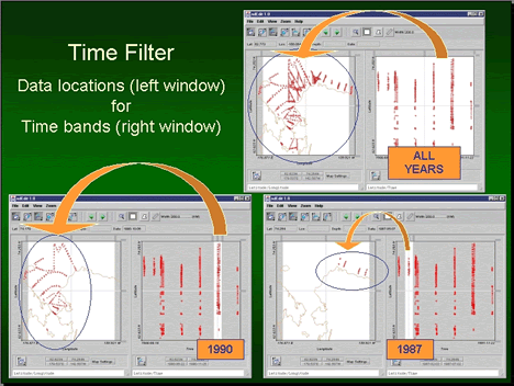
- The user can graphically view the locations of selected
data sets in any 2D view of space and time (e.g., latitude-longitude
map view or latitude-time view) and use graphical tools
to select a desired subset of the displayed data .
- Actions such as selecting or zooming in one 2D view
are duplicated in the other 2D views.
- NdEdit also features coastline and bathymetry display
in the longitude-latitude view, user-settable horizontal
and vertical axes, and zooming.
- Data sets in a selected box, polygon or multi-section
line can be deleted or retained.
NdEdit
Help and Tutorial
Applications using NdEdit:
|