Motor Vehicle Route Inventory Maps
Dispersed Camp Access Maps
These maps depict both authroized and unauthorized motor vehicle routes. Please note that motorized travel on unauthorized routes is prohibited pursuant to Forest Closure Order 08-96-02.
Viewing and Printing Instructions
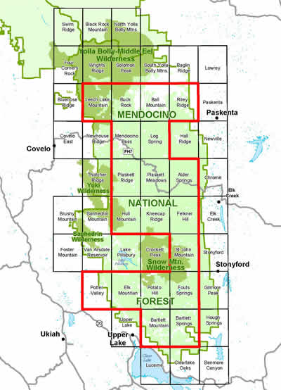
The maps are in PDF format and are viewable and printable with Adobe Acrobat Reader. The maps within the red boundary line are available for viewing and printing. Click on a map rectangle in the location map below to open the map in Adobe Acrobat Reader.
The latest version of Adobe Acrobat Reader (vers. 6.0 or 7.0) should be used to view these maps. If you are having problems viewing or printing the maps, be sure to install the latest version of the Acrobat Reader. It is free and may be downloaded from: www.adobe.com/products/acrobat/readermain.html.
DOWNLOAD TIMES: The download times for each file will vary according to connection speed and file size. All files are approximately 500 - 600 kb. On a 56k connection the download time will be approximately 2 minutes and on a 28k connection the download time will be approximately 4 minutes.
Please note that you can save the downloaded file to your computer by clicking on File and Save As on the Toolbar.
The maps are sized to print on 8.5 x 11 inch paper by clicking on the print button in Adobe Acrobat Reader.
 Printing tip: Sections of the PDF quad map may be enlarged and printed with Adobe Acrobat Reader 6.0 as follows:
- Use the magnifying glass button (Zoom In Tool) to enlarge the area you want to print.
- Click on the camera button (Snapshot Tool).
- On the map, click and drag a box over the area you want to enlarge.
- Go to File, Print and in the Print window, pick Selected Graphic and then go to Page Scaling options and choose Fit to Paper.
- Click OK to print.
Use the Adobe Acrobat Reader Help for detailed information on opening, navigating, and/or printing PDF files.