|
The
Ashland Ranger District is located in south-central Montana. The
present Ashland Ranger District was originally known as the Otter
Forest Reserve, and later became the original site of the Custer
National Forest Supervisor's Office. The Supervisor's Office was
later moved to Miles City, and then to Billings, where it is currently
located.
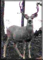
The Ashland Ranger District has the largest contiguous
block of Federal ownership in eastern Montana. This District has
one of the largest grazing programs in the nation. This area is
also rich in coal and wildlife. Some oil and gas activity has occurred,
but no producing wells have been found to date.
Picnic
and camping facilities are available at:
- Red Shale
- Holiday Springs
- Cow Creek
- Poker Jim Overlook
|
|
|
|
The District offers a variety of topography, varying from rolling
grasslands, to steep rock outcrops. Vegetation varies from prairie
to dense stands of ponderosa pine.Whitetail Cabin is available for
year-round rental by permit obtainable from the Ranger Station office
in Ashland. Charge $30 per night with a maximum limit of four nights.
The cabin will sleep four persons, has electricity, and wood is
provided; water must be brought in by the user. The cabin provides
a good location for hunting and cross-country skiing.
Fishing opportunities are few on the District, but are increasing
as reservoirs are developed and stocked with fish. Information on
which ones contain fish are accessible can be obtained from the
Ashland Ranger District office.
There are three riding and hiking areas on the District that total
about 40,000 acres. The areas are Cook Mountain, King Mountain,
Tongue River Breaks. These areas offer hunting, solitude, and a
good opportunity for nature study. Motorized travel is not permitted
and the boundaries are posted. There are no developed trails within
the areas at this time. Maps of the areas are available at Forest
Service offices in Ashland, Fort Howes, and Camp Crook, SD, and
at the Supervisor's Office in Billings.
|