Navigation Services – WAAS
Satellite-Based Augmentation System Office – News
|
WAAS and NetJets December 10, 2008 – The FAA's NextGen Program signed an agreement to implement aspects of the program with NetJets Aviation on December 10. The wide area augmentation system (WAAS) has been mentioned as one of the key technologies of use for this joint venture. If you would like to read the full article at Focus FAA, please click here. WAAS Turns "5" July 10, 2008 – Five years ago today, WAAS was commissioned into the National Airspace System. Since that time, WAAS has enabled many benefits to the aviation community and continues to evolve.
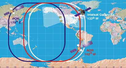
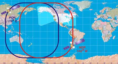
New ICAO Flight Plan Format Coming for RNAV Enroute Procedures There is a change coming on June 5th in the manner which pilots have to file flight plans if they plan on filing RNAV (GPS) instrument procedures for their navigation. Pilots have to submit the ICAO, vice the FAA flight plan form, in order to get the flight plan accepted due to recent changes to the air traffic control software. While this is not specifically a SATNAV issue, it does affect SATNAV users, so we wanted to provide our subscribers with this information and point you in the right direction for more information. More information can be found in the FAA Air Traffic Bulletin issued on March 8, 2008. The link to the bulletin is provided below. WAAS Service Expanded into Canada and Mexico September 28, 2007 - Today, the FAA GNSS Program Office announced that WAAS service is now available to users throughout Canada and Mexico.  Click image for a bigger picture The incorporation of the Canadian and Mexican WRSs meets two of the FAA Administrator’s Flight Plan goals for 2007. The first flight plan goal required that four of the international WRSs be operational by the end of September 2007. The second goal required that the remaining five international WRSs be operational by December 2007, a goal which was met four months ahead of schedule. This significant milestone for satellite navigation would not have been possible without the commitment and valuable contributions of the Canadian and Mexican aviation authorities who have supported this work at the highest levels under the auspices of the North American Aviation Trilateral Agreement. For real-time WAAS coverage, please visit the Real-Time WAAS Vertical Navigation Snapshot Display page. For information on WAAS approach procedures currently available, please visit our GPS/WAAS Approaches page. INMARSAT AOR-W satellite (PRN # 122) and POR satellite (PRN #134) to be phased out July 2007 (Update) - The Atlantic Ocean Region - West (AOR-W) satellite represented by PRN #122 and the Pacific Ocean Region (POR) satellite represented by PRN #134 will cease WAAS signal-in-space (SIS) transmission on July 30th, 2007. New WAAS GEO broadcast to begin in July July 2007 - The WAAS broadcast from the Telesat geostationary satellite (PRN #138) will be operation (in Normal mode) and usable by WAAS avionics receivers on July 11. The orbital location of Telesat provides even better WAAS performance to the East Coast (high elevation) and also extends WAAS signal-in-space (SIS) coverage into northeastern Canada. Test of future performance enhancements of WAAS to temporarily limit coverage in the Northeast Between April 16th and 23rd, the FAA will be conducting a test of upcoming performance enhancements on the newest Wide Area Augmentation System (WAAS) GEO satellite, the Intelsat Galaxy XV.
During this test, the Galaxy XV satellite will be unusable by aviation users. The POR & AOR-W satellites will continue to broadcast corrections and integrity information for GPS.
Garmin® Receives WAAS Certification for GNS 400W/500W series November 9, 2006 - The GNS 400/500 series have earned the FAA's TSO C146a Gamma-3 certification, which enables pilots who upgrade their Garmin receiver to fly Localizer Performance with Vertical (LPV) guidance approaches and receive GPS navigation via the Wide Area Augmentation System (WAAS). This upgrade will allow thousands of Garmin 400 or 500 series receivers to utilize WAAS starting in 2007. For more information, please click here for the Garmin news release. WAAS approved for new, lower minimums March 2006 - In a major step that expands the benefits of satellite navigation for aviation users, the Federal Aviation Administration has announced lower localizer performance with vertical guidance (LPV) approach minima through the use of the Wide Area Augmentation System (WAAS). WAAS is now approved to provide guidance down to 200 feet above an airport’s surface for LPV instrument approaches.
Please be sure to check out the latest version of the SatNav News available Online. |
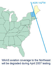 For the duration of the test, WAAS will be unavailable in the Northeast U.S, including all of Maine, New Hampshire, Vermont, Massachusetts, Rhode Island, Connecticut and parts of New York. Accordingly, all uses of WAAS for Instrument Flight Rules (IFR) navigation (including LPV, LNAV/VNAV, and enroute) will be affected for a temporary period in the area impacted by the test. Aviation users should continue to refer to the most recent NOTAMs to determine the level of service at a specific airport.