USDA Forest Service Celebrating Wildflowers
|
|
|
Pacific Southwest Region Viewing AreaLOCATION and PHOTOS
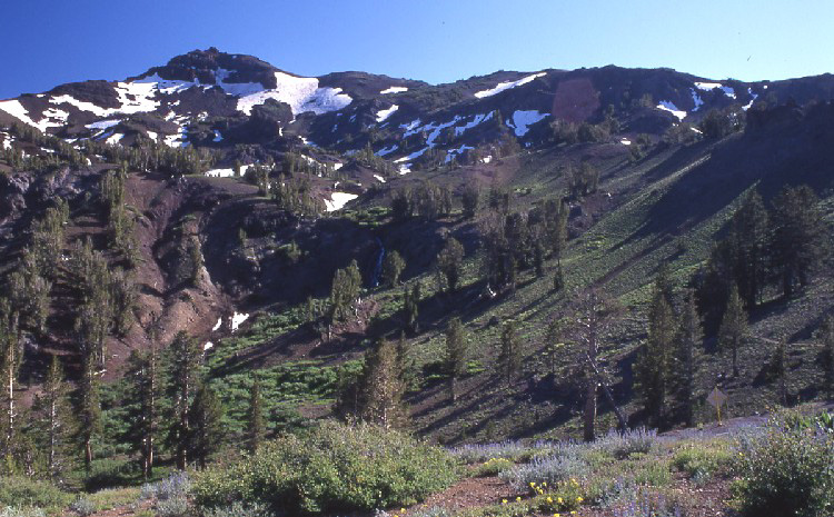
Sonora Pass and Saint Mary’s PassForest: Stanislaus National Forest District: Summit Ranger District Description: The Sonora Pass and Saint Mary’s Pass area encompasses a landscape rich in alpine botanical treasures on the Sierran crest. The area offers viewing opportunities from two trailheads, from hiking trails, and from roadside pullouts. At Sonora Pass, one can find mountain Helenium, mules ears, western peony and steershead. The Sonora Pass trailhead is a nice place to park and catch the trail to Sonora Peak where a variety of low growing alpine buckwheats and locoweeds can be found. The Saint Mary’s Pass trailhead offers easy access to a variety of subalpine riparian species such as swamp onion and columbine. Leichtlin’s mariposa lily and a variety of lupines can be found scattered among the mountain sagebrush along the lower reaches of the Saint Mary’s Pass trail. Classic alpine plants, such as Pursh’s sheeppod and Whitney’s locoweed can be found at Saint Mary’s Pass. Sierra spring beauty can be found growing among the rocks in the spring-fed creeks beyond Saint Mary’s Pass. The Sonora Peak trail is of moderate hiking difficulty. The first one-quarter mile of the Saint Mary’s Pass trail offers easy to moderate hiking difficulty. From one-quarter mile to the pass, the hiking is moderate to arduous. Once at Saint Mary’s Pass, the hiking ranges from easy to moderate, although at the very high elevation, it may seem more difficult. The areas around both trailheads offer easy to moderate walking opportunities. The trails are not open to OHVs or bicycles. Sonora Pass is at 9,643 feet elevation. Saint Mary’s Pass elevation is approximately 10,100 feet. Viewing Information: Mid- to late July is the best time to visit this area for peak wildflower bloom. Safety First: Summer thunder storms are common. Pull well off the highway when using a roadside pullout. Please don’t create new pull-outs in this sensitive area. East of Kennedy Meadows, Highway 108 becomes very steep, winding and narrow. Good brakes on your well maintained vehicle are essential. Directions: From Pinecrest, travel east on Highway 108 approximately 30 miles. The well-marked Sonora Pass trailhead is just west of the well marked Sonora Pass. The Saint Mary’s Pass trailhead is about ¾ mile west of the Sonora Pass trailhead. The sign is easy to miss on the north side of the highway. Ownership and Management: USDA Forest Service, Stanislaus National Forest. Closest Town: Pinecrest, Tuolumne County, California. |
|
|
U.S. Forest Service
|
|
| NOTE: PDF format links require the Adobe Acrobat Reader to view. | |
| top | Disclaimers | FOIA | Privacy Policy | Quality of Information | Photo Credits & Use |


Location: http://www.fs.fed.us/wildflowers/regions/pacificsouthwest/SonoraPass/index.shtml
Last modified: Tuesday, 24-Jun-2008 21:57:01 EDT