USDA Forest Service Celebrating Wildflowers
|
|
|
Pacific Southwest Region Viewing AreaPHOTOS
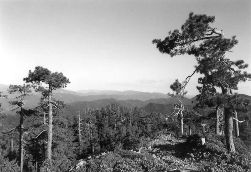
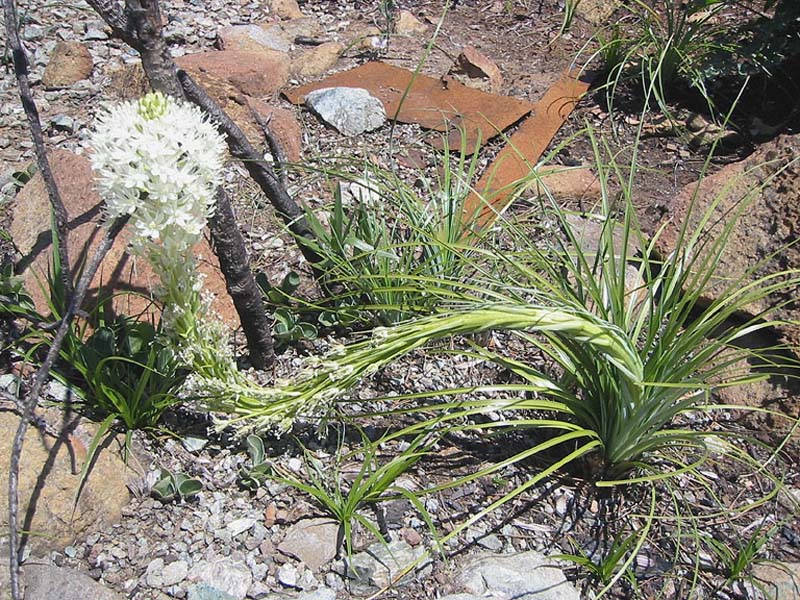
Horse Mountain Botanical AreaForest: Six Rivers National Forest District: Lower Trinity Ranger District Description: Horse Mountain Botanical Area provides commanding views of the snow-capped Trinity Alps to the east and Pacific Ocean to the west. Sculpted old-growth Jeffrey pine, rock outcrops, and streams lush with western azalea characterize the serpentine habitats of this area. The Horse Mountain Botanical Area is approximately 1,100 acres in size. Elevation ranges from 3,900 to 4,800 feet. Viewing Information: The Botanical Area is characteristic of coastal serpentine Jeffrey pine, western white pine, and Port-orford cedar communities. Incense cedar, Douglas fir, white fir, and red fir are other conifers associated with these primary communities. Common understory vegetation associated with the Jeffrey pine community includes California fescue (Festuca californica), spreading phlox (Phlox diffusa), Tolmie’s pussyears (Calochortus tolmiei), beargrass (Xerophyllum tenax),and hoary manzanita (Arctostaphylos canescens var. sonomensis).Western white pine dominated communities on reddish soils derived from peridotite parent materials (a type of serpentine rock) support a high shrub cover including California coffee (Rhamnus californica), western serviceberry (Amelanchier alnifolia), and red huckleberry (Vaccinium parviflorum). Port-Orford cedar communities are associated with stream and seep areas, and include western azalea (Rhododendron occidentale) and California pitcher plant (Cypripedium californicum). Horse Mountain was once a busy mining area. Vestiges of past mining are still evident in the form of mine tailings, the footprint of a processing facility, and scattered pits. The Horse Mountain peak is the location of a number of cellular or communication towers. The Horse Mountain Botanical Area is accessible by County Route 1, a paved road, leading off Highway 299. Once on the Six Rivers National Forest, access to the Horse Mountain Botanical Area is by gravel Forest Service roads. There are no designated foot trails in the area or visitor facilities. Horse Mountain is best observed from the County or Forest Service roads. One road into the area is gated during the late fall and winter to prevent spread of Port-Orford cedar root disease into the uninfected creeks and drainages that are common in the area. For more information about the root disease and spread prevention measures, visit Six Rivers National Forest: Port-Orford cedar. Safety First: The County Route1 (Titlow Hill Road) is a two-lane road with pullouts; however, the road is windy. Drive slowly, stay to the right side of the road at all times, and use pullouts. Roads into the Horse Mountain Botanical Area are gravel and sections are steep. Winter conditions include snow and ice. Above all be alert and drive defensively. Directions: From the town of Arcata proceed north to Highway 299. Travel east and turn right onto Route 1 (Titlow Hill Road). The Horse Mountain Botanical Area is an approximate 10-minute drive. Contact the Lower Trinity Ranger District, Six Rivers National Forest for more access information. Ownership and Management: U.S. Forest Service, Six Rivers National Forest, Lower Trinity Ranger District. Closest Town: Arcata, California. |
|
|
U.S. Forest Service
|
|
| NOTE: PDF format links require the Adobe Acrobat Reader to view. | |
| top | Disclaimers | FOIA | Privacy Policy | Quality of Information | Photo Credits & Use |
Location: http://www.fs.fed.us/wildflowers/regions/pacificsouthwest/HorseMountain/index.shtml
Last modified: Tuesday, 02-Dec-2008 17:51:52 EST