USDA Forest Service Celebrating Wildflowers
|
|
|
Southern Region Viewing AreaLOCATION and PHOTOS
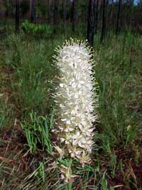
Cooter’s BogForest: Kisatchie National Forest District: Calcasieu Ranger District Description: Cooter’s Bog is a complex of several hillside pitcher-plant bogs in Vernon Parish, Louisiana. This bog complex has been estimated to cover over 130 acres on National Forest lands, with an unknown amount of acres lapping over onto private lands. The rolling landscape offers a treasure to the knowledgeable visitor. Even slight variations in the landscape can bring dramatic changes in the vegetations. Relict Longleaf Pines can be found on slightly drier, self-made hummocks, even while surrounded by standing water. Watercourses and small streams are often marked by baygalls, a combination of sweetbay (Magnolia virginiana), redbay (Persea borbonia) and gallberry (Ilex spp) shrubs. The open habitat so characteristic of the bogs can often be seen in aerial photos and satellite photos. Fingers of upland Longleaf habitat seem to separate patches of bog in this unique complex community. This hillside bog complex is surrounded by Longleaf Pine habitat, yet this very habitat provides the upland water resources, or recharge area, necessary to keep the bog functioning. Water does move, although at a very slow rate. The sandy soils allow a perculation of the water, but a very thin barrier of organic material 2-4 feet below the surface forms a nearly impermeable layer, keeping the water table high. The bog is kept open from the encroachment of trees and shrubs by prescribed fires. The fires occur roughly every one to three years, with variations due to rainfall, wind direction, and other factors that affect the safety and effectiveness of a prescribed fire. Seasonal variations in prescribed burning also encourage blooming of different species. Viewing Information: The best time for viewing this bog complex is from March to May. This is the most floristically appealing time of year for the casual wildflower viewer. Many of the carnivorous plants are also in bloom at this time of year, making them appear even more spectacular. The bog is a diverse plant habitat containing many species, including several species of carnivorous plants, such as winged pitcher plants (Sarracenia alata), sundews (Drosera spp) and butterworts (Pinguicula spp). Other endemic bog plant species include toothache grass (Ctenium aromaticum), sunbonnets, Black snakeroot (Zigadenus densus) and various bog buttons (Lachnocaulon spp & Eriocaulon spp). Many other less-common and floristically unique plants are also found in the bog. The amazing diversity of plant species may not be immediately apparent in the initial viewing of the bog. However, for any plant enthusiast, the richness becomes immediately apparent when one gets down for a “closer look” at the area. Tiny sundew leaves sparkle in the sun, thick cushions of sphagnum spring back at the touch, bladderworts (Utricularia spp) become apparent in the tiniest of pools. At the base of the bogs, nearer the stream, you can feel the heat of the sun-warmed water, and marvel at the adaptability of the plants and animals in this amazing rare community system. Safety First: Louisiana bog viewing is a lovely and incredible experience – as long as one dresses appropriately and takes precautions. Long pants and long-sleeved shirts are highly recommended, as are footwear designed to get wet. Boots with a calf-high tops are also recommended, as both western diamondbacked rattlesnakes and water moccasins have been observed in the area, especially around the permanent streams. Throughout the South, mosquitos, ticks and chiggers are present, and Cooter’s Bog is no exception. Long-sleeved shirts will help, as will application of insect repellent (either natural or man-made). Due to the open canopy present in the bog and the high water content, the area is very hot and extremely humid. Wear a hat, eye protection and sunscreen. Drink plenty of water. Also, no matter how fascinating the bog becomes, get out of the sun and into any shade at every opportunity. Directions: Cooter’s Bog is just east of state highway 463. From Hineston, drive a little over 2 miles west on state highway 121 until you reach the intersection with 463. Turn left (south) onto 463 and drive about 10.4 miles until you see the yellow and brown sign for Cooter’s Bog on your left. From Pitkin, turn onto 463, going north, from its intersection with highway 10 and drive about 6.9 miles north until you see the sign for Cooter’s bog on your right. After you turn at the sign, onto forest service road V132G, drive about 0.4 miles and park on the side of the road. There are pitcher plant bogs on either side of the road, once you walk past a thin screen of pine trees. For further information, contact Converse Griffith or Doug Rhodes at the Calcasieu District office at (318) 793-9427. The office is near Gardner, Louisiana, at 9912 Highway 28 West. Ownership and Management: National Forest Lands, Calcasieu Ranger District of the Kisatchie National Forest. Remainder of bog complex is on private lands directly east, managed by Temple Inland Lumber Company (managed for pulp production). Closest Town: The nearest town to the north of the bog is Hineston, Louisiana. The town nearest on the south is Pitkin, Louisiana. |
|
| NOTE: PDF format links require the Adobe Acrobat Reader to view. | |
| top | Disclaimers | FOIA | Privacy Policy | Quality of Information | Photo Credits & Use |
Location: http://www.fs.fed.us/wildflowers/regions/southern/CootersBog/index.shtml
Last modified: Tuesday, 24-Jun-2008 21:57:21 EDT

