USDA Forest Service Celebrating Wildflowers
|
|
|
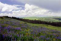
Intermountain Region Viewing AreaBob’s GardenForest: Manti-La Sal National Forest Description: Skyline Drive traverses the Wasatch Plateau on the Manti-La Sal National Forest at elevations ranging from 9,000 to nearly 11,000 feet. Many of the rolling grasslands on the Plateau are filled with wildflowers from late spring to mid summer. The drive offers spectacular views of the valleys and mountains east and west of the Plateau. The views are accentuated with incredible morning light during sunrises and with astonishing evening colors during sunsets. Spectacular billowing clouds often hover over the Plateau during the summer monsoon season. Bob’s Garden is located just off Skyline Drive, and overlooks Fairview Lakes with Mt. Nebo punctuating the western skyline. The Garden area was heavily grazed by sheep and cows in the first half of the 20th Century. Sheep tended to congregate in the area, and by the mid 1950s vegetation was completely eliminated; the area was covered only by rock and bare soil. The area was plowed and reseeded in 1956, and grazing was eliminated for 3 years; however nothing grew; almost no vegetation returned. Under Bob Thompson’s tutelage, the area was again ripped, plowed, reseeded with grasses, and rested from grazing for two years in the mid 1990s. This time the reseeding was successful. Grasses began to grow, and perennial forbs (wildflowers) have gradually repopulated the area. Bob Thompson is a renowned Botanist in the Region and has recently retired after a 54 year career with the Forest Service that began in 1951. Safety First: The main viewing area is along a gravel surface road that passes through a rolling hill area along the top of the Wasatch Plateau. At this time, there are no developed trails, viewing areas or parking lots in the "Bob's Garden" area. Wide areas and short pullouts along the road can be used during wildflower viewing. Do not obstruct traffic flow when stopping or slowing to view the flowers. Use caution when entering and exiting the roadway. Lightning and rain storms do occur in the area during the summer monsoon season. Directions: Bob’s Garden is located near the junction of State Road U31 and Beaver Dam Ridge Road. From Spanish Fork, travel east on Highway 6 to Highway 89. From there, travel south on Highway 89 to Fairview. From Fairview, travel east 14 miles on U31, past the intersection with State Highway U264, to a graveled Forest Road (#173). Turn north on Forest Road (#173), also called Beaver Dam Ridge Road, and after traveling 500 feet you will be in Bob's Garden. The Garden extends 2.5 miles along this road. Ownership and Management: U.S. Forest Service, Manti-La Sal National Forest (435) 637-2817. Closest Town: Fairview, Utah. |
|
| NOTE: PDF format links require the Adobe Acrobat Reader to view. | |
| top | Disclaimers | FOIA | Privacy Policy | Quality of Information | Photo Credits & Use |
Location: http://www.fs.fed.us/wildflowers/regions/intermountain/BobsGarden/index.shtml
Last modified: Tuesday, 24-Jun-2008 21:56:00 EDT


