skip to content program navigation
| Learn more about these WEATHER RESEARCH areas... |
Weather Modeling and Prediction
Most people don’t realize it, but weather models are one of the main tools forecasters now use to help predict the weather. While there are many types of models, the ones referred to here are numerical models. These models are comprised of a certain number of mathematical equations that represent the behavior of a physical system, such as the atmosphere. Beginning in the 1950’s, the National Weather Service (NWS) began to utilize some of the early versions of computers to make large-scale weather forecasts using numerical models. Since that time, computers have become faster and increasingly complex and sophisticated, and their ability to provide more accurate forecasts has also improved
Numerical Weather Prediction
Today’s forecasters use a system called numerical weather prediction (NWP) to forecast the weather. Developed at NOAA Research, the National Centers for Environmental Prediction (NCEP), universities and other institutions, numerical weather prediction models are one of the most important tools for forecasters. The models, using many millions of numbers that represent weather parameters such as temperature, pressure, wind, etc., attempt to represent current weather conditions and then make a prediction of the future state of the atmosphere. This is done using a grid system to divide up the atmosphere at many levels in the vertical, from the surface of the Earth to the stratosphere. At each level the horizontal spacing between points is regular, usually a set number of kilometers.
Data Assimilation is the process whereby weather observations are incorporated into a computer model that predicts the weather. After billions of calculations, the supercomputers that are now used to run weather models, project how the current weather conditions are expected to change. The computers produce forecasts at 12, 24, 36, 48, 72 hours and beyond, and these forecasts are sent to NWS forecast offices and other users. Forecasters use these model predictions as guidance, comparing different models to come up with an accurate forecast.
Weather Model Research
Since the National Weather Service is responsible for issuing all public weather forecasts in the U.S., it is constantly working with research partners to improve its ability to forecast the weather. NOAA’s research labs, along with other groups, are involved in doing innovative research to develop and improve weather models. The Regional Analysis and Prediction Branch (RAP) of the Earth System Research Laboratory (ESRL) is mainly focused on research and development for the Rapid Update Cycle (RUC) model, which provides high frequency, hourly analyses of conventional and new data sources over the contiguous United States, and short range numerical forecasts in support of aviation and severe storm forecasting. ESRL develops, implements and tests RUC improvements and then transfers them to NCEP , which runs the RUC model operationally.
Another new model that researchers are working on is the Weather Research and Forecasting Model (WRF). One of the goals of the WRF model project is to develop a next-generation forecast model and assimilation system that will advance both the understanding and prediction of important local weather systems, and promote closer ties between the research and operational forecasting communities. The model and associated system are being developed as a collaborative effort among ESRL, NCEP, the Geophysical Fluid Dynamics Laboratory (GFDL), the National Center for Atmospheric Research (NCAR) the Center for the Analysis and Prediction of Storms (CAPS), and other research institutions and universities. The first operational implementation of the WRF occurred in June 2006.
A component of ESRL, the Local Analysis and Prediction System (LAPS) Branch, carries on high resolution analyses and forecasts of weather using locally and centrally available meteorological observations. LAPS integrates data from virtually every meteorological observation system into a very high-resolution gridded framework centered on a NWS forecast office’s domain of responsibility. It includes data from surface observing systems, Doppler radars, satellites, wind and temperature profilers and aircraft. All of this information is incorporated every hour into a three-dimensional grid covering a 1040-km by 1240-km area. Using LAPS analyses, a variety of models are used to provide short-term forecasts.
Hurricane Model
Since 1995, the GFDL Hurricane Prediction System has provided operational guidance for forecasters at the National Hurricane Center (NHC) in both the Atlantic and East Pacific basins. Developed at NOAA’s Geophysical Fluid Dynamics Laboratory (GFDL) in Princeton, New Jersey, a version of the GFDL model has also been used by the Navy to provide operational guidance for storms in most of the other ocean basins as well. GFDL continues to work on improving this model and has run it during hurricane season for the last several years with significant success.
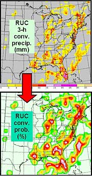
The RUC model provides high frequency, hourly analyses of conventional and new data sources over the contiguous United States, and short range numerical forecasts in support of aviation and severe storm forecasting. Convective probability forecast from the model convective precipitation field. (larger image)
Researchers are collaborating on the Weather Research and Forecasting model, the next generation forecast model and assimilation system. (larger image)
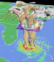
GFDL researchers created this three-dimensional visualization of a modeled hurricane off the coast of Florida. |

NOAA Research programs that develop weather models
![]() Earth
System Research Laboratory
(ESRL)
Earth
System Research Laboratory
(ESRL)
![]() Geophysical
Fluid Dynamics Laboratory (GFDL)
Geophysical
Fluid Dynamics Laboratory (GFDL)
NOAA operational groups
![]() National Centers for Environmental Prediction (NCEP)
National Centers for Environmental Prediction (NCEP)
![]() National Weather
Service (NWS)
National Weather
Service (NWS)
![]() Environmental Modeling Center (EMC)
Environmental Modeling Center (EMC)