Top News of the Day
Watches &
Warnings
Observations Forecast Graphics Rivers &
Lakes
 Climate  Spotter Reports
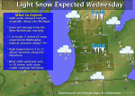
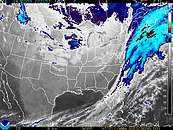
Click on the map below for the latest forecast.
Last map update: Tue, Jan. 13, 2009 at 11:39:38 pm EST
Read watches, warnings & advisories
National Weather Service Green Bay, WI National Weather Service Gaylord, MI National Weather Service Buffalo, NY
National Weather Service Milwaukee/Sullivan, WI
Zoom
Out

National Weather Service Detroit/Pontiac, MI
National Weather Service Chicago, IL National Weather Service Northern Indiana National Weather Service Cleveland, OH
Small Craft Advisory
Gale Watch
Lake Effect Snow Watch
Hazardous Weather Outlook
Short Term Forecast
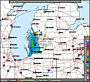
Latest Conditions in Grand Rapids, MI Choose Your Front Page City
spacer image Jan 13
10:53 pm
Partly Cloudy. Click for additional data and forecast.
Partly Cloudy
-2°F
(-19°C)
spacer image spacer image

Weather Story
Weather Story of the Day - Click to enlarge
Radar
Local Radar for Grand Rapids, MI - Click to enlarge
Satellite
Regional Infrared Satellite Image - Click to enlarge
Weather Map
National Weather Map - Click to enlarge
Skywarn Training Schedule Join CoCORaHS Get weather forecasts on mobile devices

Current Climate Plots

Grand Rapids (KGRR)
Current Climate Plot for Grand Rapids. Click for current F6 Report for Grand Rapids
Lansing (KLAN)
Current Climate Plot for Lansing. Click for current F6 Report for Lansing
Muskegon (KMKG)
Current Climate Plot for Muskegon. Click for current F6 Report for Muskegon

On January 13 in Southwest Lower Michigan…

1/13/1912
Record lows of 17 below zero at Lansing and 14 below zero at Grand Rapids contribute to January 1912 becoming the coldest January on record at both sites.
1/13/1952
Dense fog with visibility near zero leads to a number of auto accidents across southwest Lower Michigan. The fog persists for three days from the 12th to the 14th.
1/13/1979
A massive storm dumps heavy snow across southern Lower Michigan. Temperatures in the teens and strong winds lead to heavy drifting of the powdery snow, causing travel to come to a halt. The snow, at times falling at more than an inch an hour, caused power outages due to broken tree limbs. Snow accumulations were up to 3 feet, causing some roofs to collapse. South Haven had 21 inches of new snow added to 24 inches already on the ground. Grand Rapids saw 13.5 inches of snow and 2 to 4 foot drifts with wind gusts between 25 and 35 miles an hour.
More Southwest Lower Michigan Weather History…

  • NOAA's National Weather Service
  • Grand Rapids, MI Weather Forecast Office
  • 4899 South Complex Drive SE
  • Grand Rapids, MI 49512-4034
  • 616-949-0643
  • Page Author: GRR Webmaster
  • Web Master's E-mail: w-grr.webmaster@noaa.gov
  • Page last modified: 3-Jan-2008 4:18 PM UTC
USA.gov is the U.S. government's official web portal to all federal, state and local government web resources and services.