Hurricane Katrina Surge Inundation and Advisory Base Flood Elevation Maps
Tangipahoa Parish, Louisiana
FEMA has developed Hurricane Katrina Surge Inundation and Advisory Base Flood Elevation Maps (referred to as, “Katrina Recovery Maps”) to aid Tangipahoa Parish property owners to repair or rebuild structures to newly determined advisory coastal flood elevations. These maps are based on Flood Recovery Guidance for Tangipahoa Parish (PDF, 118KB) that FEMA published in November 2005.
Note: Tangipahoa Parish maps were updated in late February 2006 to revise the advisory flood elevations in Approximate Zone A areas to values currently used by the local floodplain administrator.
Frequently Asked Questions
- How do I find the Katrina Recovery Map that shows my property?
- How do I determine what Advisory Base Flood Elevation (ABFE) applies to my property?
- I know my ABFE. How high above ground does this mean I have to elevate my structure?
How do I find the Katrina Recovery Map that shows my property?
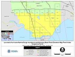 To locate a particular property, the first step is to determine which detailed Katrina Recovery Map panel applies to the area of interest. Users should first consult the Tangipahoa Parish Index Map (PDF 0.5 MB), which shows which panels were produced and what area is covered by each. Panel numbers are shown in green text (e.g., PP25). Panels were only produced for areas where structures or other significant development could be observed on recent aerial photography.
Once the detailed Katrina Recovery Map panel number is known, it can be opened by clicking on the corresponding panel number on the parish map immediately below. The panel will open up in the internet browser window using the Adobe Acrobat Reader software. The Katrina Recovery Map panels range in size from 1.1 MB to 2.2 MB.
Katrina Recovery Maps are for advisory purposes only; they do not supersede effective Flood Insurance Rate Maps (FIRMs). The Hurricane Katrina-related data presented are preliminary and subject to update as additional data become available.
How do I determine what Advisory Base Flood Elevation (ABFE) applies to my property?
The Katrina Recovery Maps depict ABFEs (that is, elevations that FEMA recommends be used for rebuilding) for defined areas or zones. The visual appearance of these advisory zones and elevations was intentionally made similar to the format of flood hazard data shown FEMA’s Flood Insurance Rate Maps (FIRMs). [Note: Individuals unfamiliar with FIRMs can view the online tutorial, “How to Read a Flood Insurance Rate Map (FIRM).”]
On the Katrina Recovery Maps, each ABFE zone is outlined in yellow and is labeled with the applicable advisory flood zone type and whole-foot elevation (e.g., ABFE VE17). ABFEs are measured relative to the National Geodetic Vertical Datum of 1929 (NGVD29), or roughly sea level. The whole-foot ABFE listed on each contour can be directly applied to properties located within the zone. On some maps, a thick yellow line marks the inland limit of the ABFEs; landward of this line, ABFEs do not apply.
I know my ABFE. How high above ground does this mean I have to elevate my structure?
Since the ABFEs are measured relative to NGVD29 (or roughly sea level), property owners will need ground elevations to determine how high above grade a structure should be elevated to meet the ABFE. Property owners are advised to consult with a licensed surveyor or professional engineer to determine ground elevations at their site. Once ground elevation is known, it can be subtracted from the ABFE to calculate the height above grade that a structure’s first floor (in A Zones) or lowest horizontal structural member (in V Zones) should be elevated.
Download Plug-in
Some of the links on this page require a plug-in to view them. Links to the plug-ins are available below.
Last Modified: Tuesday, 30-May-2006 13:28:27 EDT