Hurricane Katrina Flood Recovery Maps (Mississippi)
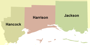
Maps showing the extent and magnitude of Hurricane Katrina’s surge, as well as information on advisory flood data, were created for the areas of Harrison, Hancock, and Jackson Counties in Mississippi that were most severely impacted by coastal flooding. These maps show high water marks surveyed after the storm, an inundation limit developed from these surveyed points, and FEMA’s Advisory Base Flood Elevations (ABFEs) and estimated zone of wave impacts. To access the Katrina Recovery Maps for each Mississippi county, click on the links below or on the map above.
Katrina Recovery Maps are for advisory purposes only; they do not supersede effective Flood Insurance Rate Maps (FIRMs) for insurance rating purposes. The Hurricane Katrina-related data presented are preliminary and subject to update as additional data become available.
FEMA, in partnership with the National Oceanic and Atmospheric Administration (NOAA), has also developed a series of detailed topographic maps for Mississippi to aid users in the interpretation of the advisory flood elevations shown on the Katrina Recovery Maps. These topographic maps, as well as an explanation on how both sets of maps may be used together, can be found on each county’s mapping home page linked above.
In addition to the detailed Katrina Recovery Map panels described above, FEMA has produced a regional overview map (PDF 0.9 MB) of the Mississippi Gulf Coast. This overview map shows the paneling scheme for the recovery maps, the Hurricane Katrina preliminary High Water Mark (HWM) locations, the Katrina surge inundation limit, and Katrina storm surge elevation contours. The latter feature is based on an assessment of the general surge trends interpreted from the surveyed HWMs, engineering judgment concerning general surge behavior in coastal areas, and an evaluation of numerical surge forecasts (e.g., SLOSH model runs) prepared by the National Oceanic and Atmospheric Administration’s Tropical Prediction Center.
Download Plug-in
Some of the links on this page require a plug-in to view them. Links to the plug-ins are available below.
Last Modified: Friday, 26-May-2006 11:22:29 EDT