Hurricane Katrina Surge Inundation and Advisory Base Flood Elevation Maps
Hancock County, Mississippi
FEMA has developed two sets of detailed maps to aid Hancock County property owners to repair or rebuild structures to the newly determined advisory coastal flood elevations:
- Hurricane Katrina Surge Inundation and Advisory Base Flood Elevation Maps (referred to as, “Katrina Recovery Maps”), and
- Provisional Topographic Elevation Contour Maps (referred to as, “Topographic Maps”). Information on how to find the right maps and determine the appropriate advisory flood elevations are provided below.
Frequently Asked Questions
- How do I find the Katrina Recovery Map that shows my property?
- How do I determine what Advisory Base Flood Elevation (ABFE) applies to my property?
- I know my ABFE. How high above ground does this mean I have to elevate my structure?
How do I find the Katrina Recovery Map that shows my property?
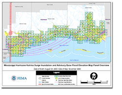 To locate a particular property, the first step is to determine which map panel applies to the area of interest. The paneling scheme (or index) for the Mississippi Gulf Coast counties is shown on the Overview Map (PDF 0.9MB). For example, parts of Bay St. Louis are shown on panels F11 and G11, the open coast of Biloxi spans many panels near I22 to I26, and much of Pascagoula appears on H36 and H37.
Once the map panel number is known, the Katrina Recovery Map can be opened by clicking on the corresponding panel number on the county map immediately below. These files range in size from 1.1 MB to 2.7 MB. For an explanation of the features shown on the Katrina Recovery Maps, please read the “Notes to Users” (PDF 31KB).
Please note: FEMA uploaded revised versions of panels F10, G10, and G11 on March 17, 2006.

Katrina Recovery Maps are for advisory purposes only; they do not supersede effective Flood Insurance Rate Maps (FIRMs). The Hurricane Katrina-related data presented are preliminary and subject to update as additional data become available.
How do I determine what Advisory Base Flood Elevation (ABFE) applies to my property?
The Katrina Recovery Maps show ABFE contours as yellow and red lines labeled with coastal flood elevations, which are measured relative to the North American Vertical Datum of 1988 (NAVD88) or roughly sea level. The whole-foot ABFE listed on each contour can be directly applied to properties located along that contour; for properties situated between contour lines, the ABFE must be interpolated. For example, if a property is located half-way between the 19- and 20-foot ABFE contours, the ABFE at the site is approximately 19.5 feet. Property owners should seek assistance from their local floodplain administrator for site-specific ABFE determinations.
I know my ABFE. How high above ground does this mean I have to elevate my structure?
Since the ABFEs are measured relative to NAVD88 (or roughly sea level), property owners will need ground elevations to determine how high above grade a structure should be elevated to meet the ABFE. The National Oceanic and Atmospheric Administration (NOAA) provided FEMA with provisional, high-resolution topographic data collected in 2004 to use in developing the Katrina Recovery Maps. With NOAA’s permission, FEMA has produced a separate series of Topographic Maps based on this dataset, with ground elevations shown in 2-foot contours. These maps, which follow the same paneling scheme as the recovery maps, can be opened by clicking on the corresponding panel number on the county map immediately below. These files range in size from 1.2 MB to 4.2 MB.

The topographic data shown on these maps are provisional and subject to final verification and approval by NOAA. Therefore, these data are for advisory purposes only, and do not replace an official site survey completed by a licensed surveyor or professional engineer for permitting purposes.
Once both the Katrina Recovery Map and the Topographic Map for a site are obtained, users need only to subtract the site’s ground elevation (topographic elevation) from the site’s ABFE to calculate the approximate elevation above grade. For example, the recovery map (Figure 1) and topographic map (Figure 2) for an area in Biloxi are shown below. The property circled in blue has an ABFE of approximately 21.5 feet (located between the yellow 21- and 22-foot ABFE contours), and a ground elevation of approximately 11 feet (located between the purple 10- and 12-foot topographic contours). To meet the level of flood protection established by the ABFE, any structure on this site would need to be elevated approximately 10.5 feet above grade (21.5 feet minus 11 feet).

Figure 1
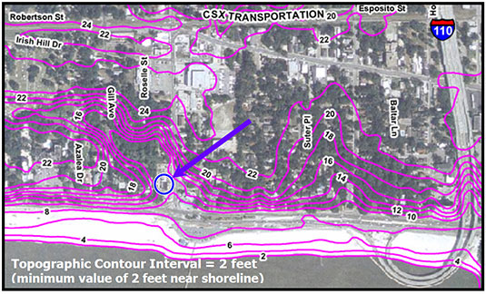
Figure 2
Download Plug-in
Some of the links on this page require a plug-in to view them. Links to the plug-ins are available below.
Last Modified: Wednesday, 31-May-2006 12:31:06 EDT