| NOAA Magazine || NOAA Home Page |
NOAA PROVIDES WRAP-UP ON VERY ACTIVE 2004 ATLANTIC HURRICANE SEASON
 Nov.
30, 2004 � The 2004
Atlantic hurricane season was one for the record books, say NOAA
hurricane and climate prediction specialists. Nine named storms affected
the United States during the six-month hurricane season—three
as tropical storms (Bonnie, Hermine and Matthew) and six as hurricanes
(Alex, Charley, Frances, Gaston, Ivan and Jeanne). Three of the hurricanes
(Charley, Ivan, and Jeanne) made landfall as major hurricanes. Nature's
favorite target this season was the state of Florida, which was affected
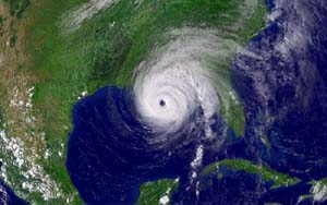
by four hurricanes and one tropical storm. (Click NOAA satellite
image for larger view of Hurricane Ivan taken at 4:15 p.m. ET on Sept.
15, 2004, just hours before making landfall on the USA Gulf Coast. Click
here for high resolution version, which is a large file. Please
credit “NOAA.”)
"During late summer it seemed that each day's headlines highlighted the impact of this hurricane season," said Brig. Gen. David L. Johnson, U.S. Air Force (Ret.), director of the NOAA National Weather Service. "Property damage was significant, but in the United States, loss of life—while always tragic—was minimized due in large part to heightened public awareness, preparation and response to our forecasts of these dangerous tropical systems."
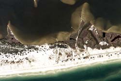 (Click NOAA undated aerial image for larger view of Gulf Shores, Ala., to see how this particular region appeared before Hurricane Ivan struck on Sept. 16, 2004. Click here for high resolution version, which is a large file. Please credit “NOAA.”) |
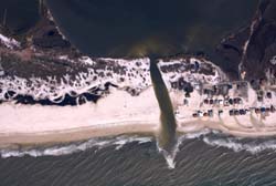 (Click NOAA aerial image for larger view of Gulf Shores, Ala., after Hurricane Ivan made landfall on Sept. 16, 2004, to see how the powerful storm cut a swath across a barrier island. Click here for high resolution version, which is a large file. Please credit “NOAA.”) |
NOAA's seasonal hurricane outlook issued in May called for 12 to 15 named storms, six to eight hurricanes and two to four major hurricanes. The season actually produced 15 named storms, of which nine became hurricanes, and six became "major" (Category 3 or higher on the Saffir-Simpson Hurricane Scale). In the month of August alone, eight systems reached tropical storm strength, breaking the previous record of seven in 1933 and 1995. The annual outlook is the work product of the combined efforts of NOAA's Climate Prediction Center, Hurricane Research Division and the National Hurricane Center.
![]() "What
could not be anticipated this season was the high number of U.S. landfalling
hurricanes," added Johnson. On average, the U.S. experiences two
to three landfalling hurricanes during above-normal hurricane seasons,
well below the eight landfalls recorded this year (Alex is not officially
counted as a landfall since the center of its eye remained offshore).
(Click NOAA image for larger view of Hurricane Ivan tracking
map. Click here
for high resolution version, which is a large file. Please credit “NOAA.”)
"What
could not be anticipated this season was the high number of U.S. landfalling
hurricanes," added Johnson. On average, the U.S. experiences two
to three landfalling hurricanes during above-normal hurricane seasons,
well below the eight landfalls recorded this year (Alex is not officially
counted as a landfall since the center of its eye remained offshore).
(Click NOAA image for larger view of Hurricane Ivan tracking
map. Click here
for high resolution version, which is a large file. Please credit “NOAA.”)
This is the first time since record-keeping began in 1851 that four hurricanes have impacted Florida in one year. The only other state to have experienced this level of activity was Texas in 1886. Hurricane Ivan was an encore performer with two landfalls during 2004, first as a Category 3 hurricane near Gulf Shores, Ala., and second as a tropical storm over southwestern Louisiana.
 Human
and economic impacts were considerable. Direct U.S. hurricane-related
fatalities totaled 59. Florida bore the brunt of U.S. property damage,
with damage estimates (adjusted to year 2000 dollars) expected to eclipse
the $34.9-billion in damage caused by Hurricane Andrew in 1992. The
Insurance Information Institute estimates that one in every five Florida
homes was impacted by a hurricane to some degree this year. Some 9.4
million Florida residents were evacuated from their homes this season.
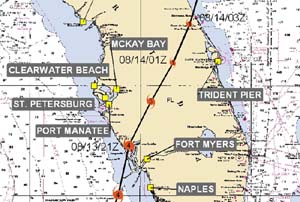
(Click NOAA image for larger view of Hurricane Charley tracking
map, which shows the storm making landfall near Cayo Costa, just north
of Captiva Island, on Aug. 13, 2004, and then moving across the state
of Florida. Click here
for high resolution version, which is a large file. Please credit “NOAA.”)
Scientists point to the multi-decadal fluctuations in seasonal activity as a primary factor leading to the high number of hurricanes during 2004. During 1995-2004 eight of ten Atlantic hurricane seasons were above normal (the exceptions being the El Niño years of 1997 and 2002), increasing the potential for more landfalling hurricanes. During 2004, the hurricane landfalls were also related to a strong region of high pressure over the western Atlantic in the middle levels of the atmosphere, which helped to steer hurricanes toward the United States rather than out to sea.
 "The
2004 season was one to tell your grandchildren about," said Max
Mayfield, NOAA's National Hurricane Center director. "I believe,
and stress at every opportunity, that residents should have a plan,
stay informed and act when told to do so by their local officials. We
should mark November 30th not as the end of the 2004 hurricane season
but the beginning of the six months we have to prepare for next season."
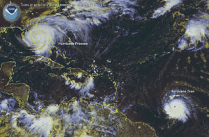
(Click NOAA satellite image for larger view of Hurricanes Frances
and Ivan taken at 11:15 a.m. ET on Sept. 5, 2004, as Frances makes its
way across Florida and Ivan marches across the Caribbean for an eventual
landfall in the USA Gulf Coast. Click
here for high resolution version, which is a large file. Please
credit “NOAA.”)
The NOAA National Weather Service is the primary source for weather data, forecasts and warnings for the United States and its territories. The NOAA Weather Service operates the most advanced weather and flood warning and forecast system in the world, helping to protect lives and property and enhance the national economy.
NOAA is dedicated to enhancing economic security and national safety through the prediction and research of weather and climate-related events and providing environmental stewardship of the nation�s coastal and marine resources. NOAA is part of the U.S. Department of Commerce.
Relevant Web Sites
Details of
the 2004 Hurricane Season Storms
NOAA Takes Aerial Images of Florida Regions Affected by Hurricane Jeanne
NOAA Posts Aerial Images of Hurricane Ivan’s Destruction
NOAA Captures the Eyewall of Hurricane Jeanne
NOAA Enhanced Satellite Imagery of Tropical Storms & Hurricanes
NOAA
Atlantic Hurricanes Database — 150 Years of Atlantic Hurricanes
Saffir-Simpson Hurricane
Scale
Media
Contact:
Frank
Lepore, NOAA Hurricane Center,
(305) 229-4404 or Carmeyia
Gillis, NOAA Climate Prediction
Center, (301) 763-8000 ext. 7163