Legend of Surface Front Types Description of Station Plot Data
Short Range Forecasts
Precipitation Areas and Symbols
FORECAST DISCUSSION: NFDPMDSPD (FXUS01 KWBC)
About the Surface Analyses
About the Short Range Forecasts
![[30-hour fcst valid 06 or 18 UTC]](https://webarchive.library.unt.edu/eot2008/20090114123430im_/http://www.hpc.ncep.noaa.gov/basicwx/95fwbgus_sm.jpg) 30 hour
30 hour
![[36-hour fcst valid 00 or 12 UTC]](https://webarchive.library.unt.edu/eot2008/20090114123430im_/http://www.hpc.ncep.noaa.gov/basicwx/96fwbgus_sm.jpg) 36 hour
36 hour
![[48-hour fcst valid 00 or 12 UTC]](https://webarchive.library.unt.edu/eot2008/20090114123430im_/http://www.hpc.ncep.noaa.gov/basicwx/98fwbgus_sm.jpg) 48 hour
48 hour
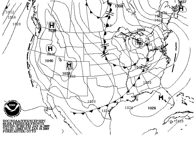
![[60-hour fcst valid 00 or 12 UTC]](https://webarchive.library.unt.edu/eot2008/20090114123430im_/http://www.hpc.ncep.noaa.gov/basicwx/99fwbgus_sm.jpg) 60 hour
60 hour


![[6-hour fcst valid 06 or 18 UTC]](https://webarchive.library.unt.edu/eot2008/20090114123430/http://www.hpc.ncep.noaa.gov/basicwx/91fwbgus.jpg)
![[12-hour fcst valid 00 or 12 UTC]](https://webarchive.library.unt.edu/eot2008/20090114123430/http://www.hpc.ncep.noaa.gov/basicwx/92fwbgus.jpg)
![[18-hour fcst valid 06 or 18 UTC]](https://webarchive.library.unt.edu/eot2008/20090114123430/http://www.hpc.ncep.noaa.gov/basicwx/93fwbgus.jpg)
![[24-hour fcst valid 00 or 12 UTC]](https://webarchive.library.unt.edu/eot2008/20090114123430/http://www.hpc.ncep.noaa.gov/basicwx/94fwbgus.jpg)
![[30-hour fcst valid 06 or 18 UTC]](https://webarchive.library.unt.edu/eot2008/20090114123430/http://www.hpc.ncep.noaa.gov/basicwx/95fwbgus.jpg)
![[36-hour fcst valid 00 or 12 UTC]](https://webarchive.library.unt.edu/eot2008/20090114123430/http://www.hpc.ncep.noaa.gov/basicwx/96fwbgus.jpg)
![[48-hour fcst valid 00 or 12 UTC]](https://webarchive.library.unt.edu/eot2008/20090114123430/http://www.hpc.ncep.noaa.gov/basicwx/98fwbgus.jpg)
![[60-hour fcst valid 00 or 12 UTC]](https://webarchive.library.unt.edu/eot2008/20090114123430/http://www.hpc.ncep.noaa.gov/basicwx/99fwbgus.jpg)