|
ALOHA
ALOHA (Areal Locations of Hazardous Atmospheres) is a modeling program that estimates threat zones associated with hazardous chemical releases, including toxic gas clouds, fires, and explosions. A threat zone is an area where a hazard (such as toxicity, flammability, thermal radiation, or damaging overpressure) has exceeded a user-specified Level of Concern (LOC).
 |
|
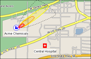
An ALOHA threat zone plot displayed on a MARPLOT map. The red, orange, and yellow zones indicate areas where specific Level of Concern thresholds were exceeded.
|
Key Program Features
- Generates a variety of scenario-specific output, including threat zone plots, threat at specific locations, and source strength graphs.
- Calculates the rate of release for chemicals escaping from tanks, puddles (on both land and water), and gas pipelines and predicts how that release rate changes over time.
- Models many release scenarios: toxic gas clouds, BLEVEs (Boiling Liquid Expanding Vapor Explosions), jet fires, vapor cloud explosions, and pool fires.
- Evaluates different types of hazard (depending on the release scenario): toxicity, flammability, thermal radiation, and overpressure.
- Displays threat zones on MARPLOT maps (and on ArcView and ArcMap with the Arc Tool extensions).
- Works seamlessly with companion programs CAMEO Chemicals and MARPLOT; it can also be used as a standalone program.
ALOHA was developed jointly by NOAA and the Environmental Protection Agency (EPA), and it runs on both Macintosh and Windows computers.
|