- Imagery and Basemaps
Introduction
The Imagery and Base Maps category page provides information about general base maps, place names, description, and characteristics of the land's surface.
Live Data and Maps
Content Summary: The National Map is a consistent framework for geographic knowledge needed by the Nation. It provides public access to high-quality, geospatial data and information from multiple partners to help support decisionmaking by resource managers and the public. The National Map is the product of a consortium of Federal, State, and local partners who provide geospatial data to enhance America's ability to access, integrate, and apply geospatial data at global, national, and local scales. The U.S. Geological Survey (USGS) is committed to meeting the Nation's needs for current base geographic data and maps. Our vision is that, by working with partners, we will ensure that the Nation has access to current, accurate, and nationally consistent digital data and topographic maps derived from those data.
Go to websiteContent Summary: The U.S. Geological Survey (USGS), along with the National Geospatial-Intelligence Agency (NGA), are acquiring high resolution orthoimagery for the major metropolitan areas, and state capitals of the United States. As an essential element of The National Map, the need for up-to-date imagery is critical for Homeland Security and Emergency Response. The Orthoimagery category is one of the framework layers for The National Map.
Go to website
Content Summary: The U.S. Geological Survey has developed a Seamless data collection. This document pertains to the web-mapping service for display and delivery of this data. The Seamless Data Distribution System (SDDS) is the ultimate location to explore and retrieve data. The U.S. Geological Survey (USGS) and the Center for Earth Resources Observation & Science (EROS) are committed to providing access to geospatial data through The National Map. An approach is to provide free downloads of national base layers, as well as other geospatial data layers. These layers are divided into framework categories of Places, Structures, Transportation, Boundaries, Hydrography, Orthoimagery, Land Cover, and Elevation. Along with providing access to the data, the site contains: Tutorial to help with downloads, Information about the downloadable products, Frequently Asked Questions, Links to product homepages and information pages. The SDDS is always growing with new data, tools, features, and much more.
Content Type: Applications
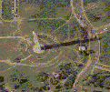
Content Summary: High-resolution digital orthorectified imagery from aerial photographs. The Urban Area High Resolution Orthoimagery is now available for download through the USGS Seamless Data Distribution System, Earth Resources Observation and Science (EROS) at http://seamless.usgs.gov/website/seamless/index.htm.
Content Type: Applications
Content Summary: High resolution, unrestricted, orthoimagery for the gulf coast and east coast of the United States. The area-of-interest extends from the southernmost tip of Texas, north to Cape Cod, extending three counties deep from the coastline. A variety of high-resolution imagery will be made available such as 3-inch, 6-inch and 1-foot natural color. These data will be the most recent collected by the USGS. Users can access the imagery through a simple WMS viewer by pasting in this GetCapabilities link: http://iq.usgs.gov/cgi-bin/nuiwms.exe?request=getcapabilities&service=WMS&version=1.1.1
Content Type: Live data & maps
Content Summary: The Geographic Names Information System (GNIS), developed by the USGS in cooperation with the U.S. Board on Geographic Names (BGN), contains information about almost 2 million physical and cultural geographic features in the United States. The Federally recognized name of each feature described in the data base is identified, and references are made to a feature's location by State, county, and geographic coordinates.
Content Type: Live data & maps
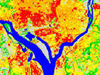
Content Summary: The USGS, in cooperation with the USEPA, has produced a land cover dataset for the conterminous US, based on Landsat Thematic Mapper imagery (circa 1992)and supplemental data. The National Land Cover Dataset (NLCD) contains 21 categories of land cover information.
Content Type: Live data & maps
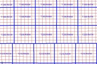
Content Summary: National Integrated Land System (NILS) - Land Survey Information System is the official federal government website for the distribution of the Public Land Survey System - PLSS of the United States and other survey-based data for the federal government. The spatial data layer is from the BLMs National Integrated Land System (NILS) and is based on BLMs Geographic Coordinate Data Base (GCDB) coordinate data. The data can be downloaded from GeoCommunicator (www.geocommunicator.gov) as GIS shapefiles and includes township, section, and subdivision of sections. Metadata is available from the GeoCommunicator website. Data from the U.S. Forest Service and other federal, state, and local agencies is available as alternate source data. Website: http://www.geocommunicator.gov, Map server: http://www.geocommunicator.gov, Service Name:BLM_MAP_PLSS or BLM_LSIS_wms
Content Type: Live data & maps
Content Summary: The Surface Management Agency map service is a seamless spatial layer of the federal surface land management boundaries. The layer was developed by the BLM using data from the BLM, NPS, USFS and USGS.
Content Type: Live data & maps
Content Summary: The USGS Landsat 7 orthoimage service has been developed byextracting non-overlapping coverage from hundreds of Landsatscenes over the United States. This creates a full coveragedatabase that are NOT radiometrically blended, but that fillout a mosaic that can be refreshed as new cloud-free scenesare acquired.
Content Type: Live data & maps
Imagery and Data Catalog Online Applications
Content Summary: Huge clearinghouse for searching for a variety of maps and imagergy. Subjects include: climate, DLGs, elevation, geology, hydrology, land cover, maps, aerial photographs and satellite imagergy (AVHRR, MSS, Landsat TM, etc.). Products can be ordered for a fee, but the site is also great a resource tool as abstracts and descriptions are provided about the prodcuts.
Content Type: Clearinghouses
Content Summary: The USGS Global Visualization Viewer (GloVis) is a quick and easy online search and order tool for selected satellite data. The viewer allows user-friendly access to all available browse images from the Landsat 7 ETM+, Landsat 4/5 TM, Landsat 1-5 MSS, EO-1 ALI, EO-1 Hyperion, MRLC, and Tri-Decadal data sets, as well as Aster TIR, Aster VNIR and MODIS browse images from the DAAC inventory. Through a graphic map display, the user can select any area of interest and immediately view all available browse images within the USGS inventory for the specified location. From the browse image viewer page, the user may either navigate to view adjacent scene locations or select a new area of interest. GloVis also offers additional features such as cloud cover limits, date limits, user-specified map layer displays, scene list maintenance, and access to metadata. An ordering interface is available for Landsat, EO-1, MRLC, Tri-Decadal, ASTER and MODIS data purchases. Future GloVis releases will include the addition of data from other datasets within the USGS EROS archives.
Content Type: Applications
Other Resources
Content Summary: FGDC Content Standards. Standards facilitate the development, sharing, and use of geospatial data. The FGDC develops geospatial data standards for implementing the NSDI, in consultation and cooperation with State, local, and tribal governments, the private sector and academic community, and, to the extent feasible, the international community
Go to website