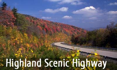
The Highland Scenic Highway is a
beautiful corridor through the National Forest. This National
Forest Scenic Byway extends 43 miles from Richwood to US Route
219, seven miles north of Marlinton. The Highway follows State
Route 39/55 for 21 miles from Richwood to the Cranberry
Mountain Nature Center
and passes by Falls
of Hills Creek. It then
turns onto State Route 150 for the 22 mile Parkway section that
passes by the Cranberry
Glades and the Cranberry
Wilderness. The Highway
traverses the mountainous terrain of the Allegheny Highlands and
Plateau, and rises from Richwood, elevation 2,325 feet, to over
4,500 feet along the Parkway.
The Highway is a paved two-lane
road. Speed limits are 55 mph for the State Route 39/55 section
and 45 mph for the Parkway section. Commercial truck traffic is
not allowed on the Parkway. The Parkway is not maintained for
winter travel, and is normally closed from early December to March.
|
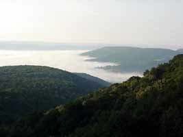
Scenic
Overlooks
Four Scenic overlooks located
on the Parkway portion of the Highway provide spectacular
views of the Allegheny Highlands. On clear days, views of
the surrounding ridges and valleys are a special attraction.
Spring blossoms, summer wildflowers, and autumn leaves offer
color throughout the season. Barrier-free picnic shelters
and restrooms are provided at each overlook.
|
|
Camping
Three campgrounds are located a
short drive from the Highland Scenic Highway: Summit
Lake, Tea
Creek, and Day
Run Campgrounds. Camping
is also permitted along the William's
River at designated
numbered campsites outside
of the campgrounds. Water and toilet facilities are not provided,
and no fee is charged.
For those looking for a backpacking
experience, there are a variety of camping opportunities. Some
popular areas include the Cranberry Backcountry and the Tea Creek
area. Minimum impact camping methods are encouraged, including
a pack-it-in/pack-it-out trash policy. Visitors are asked to camp
away from trails and streams.
Trails
Over 150 miles of trail are accessible
from the Highway. Three barrier-free trails serve the Falls
of Hills Creek, the Cranberry
Glades, and the Big Spruce
Overlook. Many trails are also suitable for cross-country skiing
and horseback riding. Mountain biking is permitted on most of
the trails outside of the Cranberry
Wilderness.
|
|
Services
Provided
Gas, food, and lodging are
available at Richwood, Webster Springs, and Marlinton. The
Chambers of Commerce or Tourism Commissions at these locations
will provide listings of businesses such as motels, restaurants,
and service stations upon request. Emergency services are
also available in these communities.
|
For more information contact the
Gauley Ranger District, 932 North Fork Cherry Rd., Richwood, WV
26261 (304) 846-2695 or the
Marlinton Ranger District, PO Box 210, Marlinton WV 24954 (304)799-4334.
|