HURREVAC
Evacuation Decision Assistance Tool for Government Officials
 National Hurricane Program e-mail updates
HURREVAC stands for "HURRicane EVACuation" and is a restricted-use computer program funded by FEMA and USACE for government emergency managers to track hurricanes and assist in evacuation decision-making for their communities. This real-time data analysis tool allows state and local emergency management officials to make prudent and informed decisions based on information developed during the FEMA Hurricane Evacuation Studies process and realtime forecast data distributed by the National Weather Service (NWS) and the Tropical Prediction Center/National Hurricane Center (NHC).
How Do Evacuation Clearance Times Work?
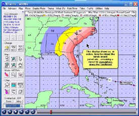
HURREVAC tracks hurricanes on computer plot maps using information from the National Hurricane Center (National Weather Service, NOAA) and estimates when various evacuation decisions should be made for threatened areas using data from the FEMA/USACE Hurricane Evacuation Study for the area. The process works the following way:
- The arrival of tropical storm winds (34 knots or 39mph) in your area is computed using the NHC projections with adjustment for a direct-hit or worst-case approach to your community.
- Evacuation Clearance times (the time it takes to get residents out of storm surge vulnerable areas are computed using Saffir-Simpson Scale category of storm, response of the public, and occupancy readings for the area. The basic data for the clearance times is produced by a local Hurricane Evacuation Study, usually performed by the Corps of Engineers and FEMA.
- The clearance time duration should be subtracted from the tropical storm winds arrival time to reach a suggested Evacuation Decision Time. Other factors, such as time of day, must be included in the evacuation decision in order to be effective. This approach is based on the need to have the at-risk population out of vulnerable areas before tropical storm winds reach the coast and weather and roadway conditions become unsafe.
Storm Surge Inundation graphics, where available, are also displayed by the program, using data from the National Weather Service SLOSH (Sea, Lake and Overland Surge from Hurricanes) model.
HURREVAC and Supporting information
For more information about HURREVAC training, registration, how to use, or other support services, please visit: www.hurrevac.com
Essentials of HURREVAC is a publication that provides more information on how to use HURREVAC effectively.
Last Modified: Tuesday, 27-Nov-2007 12:42:02 EST