RASPLOT Bulletin
Issue No. 16
The purpose of the RASPLOT mailing list is to provide up-to-date RASPLOT information and training.
The DXF Editor is the graphical plotting program used in conjunction with RASPLOT to produce standardized NFIP Flood Insurance Study profile tables. In RASPLOT, data are converted from the database files to automatically generate water-surface profiles in the FEMA-approved format, which include the water-surface profiles, table labels, legend, road crossings, bridges, and culverts. While the program generates most of the needed items for a profile table, there are several details that need to be modified and changed manually. A user will need to know how to use the tools featured in the DXF Editor in order to make these changes.
The current and upcoming bulletins will cover, in detail, how to use the specific options, tools, and buttons within the DXF Editor. Previous bulletins have already covered:
- Zoom Options
- Snap Options
- Ortho On/Off
- Draw Tools
- Modify Tools
Part 1: Erase, Copy, Move, Rotate, Scale, Text, & Explode
Part 2: Trim tools
Part 3: Extend & Break
Part 4: Fillet & Offset) - How to Create and Insert Blocks
Review: What is a Block?
A block is a series of drawing objects (lines, polylines, hatchings, and/or text) that are grouped together into an object with one assigned insertion point. As blocks can reference a series of diverse drawing items to a single point, they serve as a useful tool for generating fully customizable, duplicate graphical items that require multiple insertions in a drawing. In FIS profiles, some examples of useful blocks are stream bed hatchings, text labels, or line arrowheads.
In the RASPLOT version 2 software series, the block menu is located in the top main menu of the DXF editor screen. When selected, the submenu options are "Make Block" and "Insert Block." To make a block is analogous to creating a rubber stamp. To insert the block is like using this rubber stamp at desired locations.
Pre-installed Blocks in the DXF Editor
Currently in the RASPLOT version 2 software series, there are several pre-installed blocks available for users to insert into FIS profile tables. Pre-installed blocks are listed in the BlockName field of the popup box that is activated when the "Insert Block" command is executed (see Figure 1). Please note, however, that not all of the blocks listed are meant to be manually inserted by users. Most are automatically generated by the DXF Editor when the profile templates are created, or currently do not serve a practical function for custom use.
Figure 1: "Insert Block" Popup Box

However, the following three blocks are quite useful for adding custom detail to FIS profiles:
- BACKWATER - inserts a scaleable backwater leader line with dual arrowheads
- LEADER - inserts a scaleable, rotatable leader line with a single arrowhead
- ROCK - inserts a scaleable, rotatable streambed symbol
The following example will demonstrate the typical steps required to insert one of these pre-installed blocks. [Please Note: The Block feature is subject to change in upcoming release versions of RASPLOT]
Example of Using a Pre-installed Block: BACKWATER
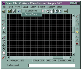 |
STEP 1: Select "Insert Block" from the Block dropdown menu |
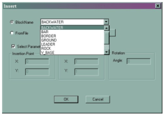 |
STEP 2: Choose the "BACKWATER" block from the BlockName list of blocks |
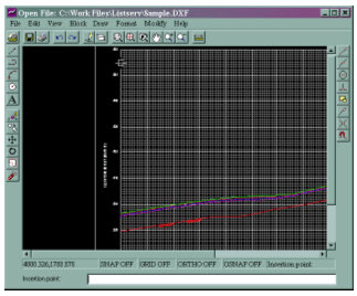 |
STEP 3: Select the insertion point at the downstream confluence |
 |
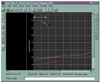
STEP 4: Scale the block to size by dragging the mouse away from the insertion point (Although a numeric scale value can also be typed in the command line box, the scale method for this feature is best applied with the mouse to size your leader line visually) |
 |
STEP 5: |
 |
STEP 6: |
Additional Tip for Users Comfortable with DXF Editor Tools
For extreme backwater lengths (very short or very long), the arrowheads at the size at which the leader line is appropriately scaled may be too small or too large. In such cases, you can do the following. Follow STEPS 1-3 of the above instructions. Scale the block to an arrowhead size that is appropriate for the entire profile. Next, Explode the block. Then, select the right arrowhead and marker and move them horizontally to the desired endpoint with the ORTHO ON feature selected. Lastly, manually extend or shorten the leader line to fit.
Please note: this suggestion is only recommended for users who are very comfortable with the different tools available within the DXF Editor.
Click here to view the archive page for all Flood Hazard Mapping listservs.
Last Modified: Tuesday, 26-Jun-2007 11:57:20 EDT