National Flood Frequency Bulletin
Issue No. 6
The purpose of the NFF mailing list is to provide information on the U.S. Geological Survey (USGS) National Flood Frequency (NFF) program. NFF is a computer application that is used to estimate peak discharges for unregulated streams. Values (discharges) derived by the program often serve as input for other applications (such as hydraulic computer models) that are used to technically support end-products (map revisions) of the National Flood Insurance Program (NFIP).
Discussion on USGS Regression Equations and the NFF Program
The USGS developed a computer program titled "National Flood Frequency" or "NFF" that estimates the flood frequency and magnitude for ungaged sites through the application of the appropriate regional regression equations. NFF was released in 1993 and does not incorporate any revisions to regional regression equations that occurred after September 30, 1993. Since 1993 a significant number of the regression equations have been revised. The USGS is in the process of revising the NFF computer program to incorporate the updated regression equations. The revised version of NFF will be released soon.
The regional regression equations are currently being used for National Flood Insurance Program (NFIP) purposes. Therefore, FEMA would like to continue with this listserv and discuss issues of interest in the application of the regional regression equations for NFIP purposes. Upon the release of the revised NFF program, the focus of this listserv will shift to assist users in becoming familiar with the revised NFF program and its application for NFIP purposes.
Unusual Parameters of USGS Regression Equations and How to Obtain Them - Part 2
Some unusual parameters must be developed to correctly apply the equations for several States. Last month we discussed main channel slope, Sl; main channel length, L; average basin elevation, El; basin relief, BR. This month we will discuss forest cover, F; runoff-curve number, RCN; and storage in lakes, ponds, and swamps, ST. Next month we will discuss basin development factor, BDF; area of limestone or Karst geology, LI; and mean basin slope, Sb.
Forest cover, F, appears in several of the States' revised equations discussed in the August bulletin. Areas of forest cover can be easily estimated using the USGS 7.5' topo map(s) or aerial photographs covering the basin. The simplest way to make the estimate is by using an engineer's scale and resolving by eye the green-tinted areas on the USGS map into approximate equivalent rectangles or triangles. The dimensions of these areas can be estimated and calculations of square footage can be accumulated. Large contiguous areas of forest on the map or aerial photos can also be measured by planimeter.
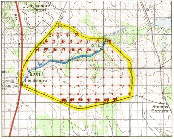
On the map above from last month's example, the average forested widths along channel or swale areas can be estimated and multiplied by lengths along the direction of flow. For the main channel of Hangmans Run, we estimated an average width of 300' a nd multiplied it by a length of 4,000' to get 1,200,000 sq. ft. Doing the same for the 3 tributary areas results in additional calculations of 200' x 1,000' = 200,000 sq. ft., 300' x 1,500' = 450,000 sq. ft., and 300' x 500' = 150,000 sq. ft. Finally, we estimated the western-most area (under the "Fieldsboro" label) to be an average of 500' wide by 800' long for another 400,000 sq. ft. Summing the areas and dividing by 43,560 sq. ft. per acre, we get 1,200,000 + 200,000 + 450,000 + 150,000 + 400,000 = 2,400,000 sq. ft./ 43,560 = 57.5 acres. F can then be calculated by dividing the forested area by the total drainage basin area of 525 acres and multiplying by 100 to get percent: (57.5/525) 100 = 11%.
Runoff curve number, RCN, refers to the parameter from the National Resource Conservation Service (NRCS) hydrology method. A detailed discussion of this parameter can be found in the NRCS publications Urban Hydrology for Small Watersheds, Technical Release 55 (TR-55), June 1986, and National Engineering Handbook, Section 4, Hydrology, March 1985. The major factors that determine RCNs are the types of soils in the basin, types of ground cover and treatment of land, the hydrologic condition of the soil, and the antecedent runoff condition.
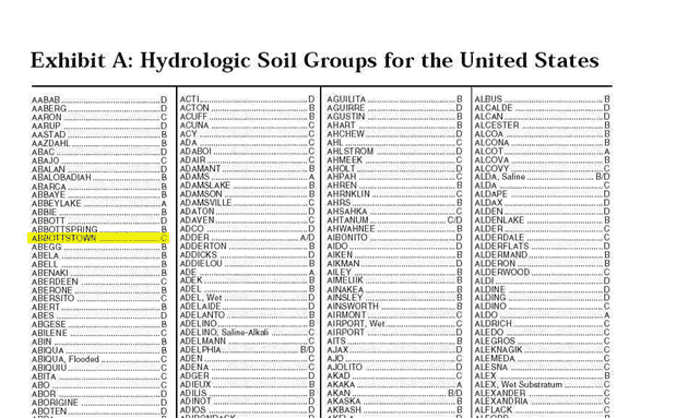
The soils have been classified into four major hydrologic soil groups (HSGs) A, B, C, and D by the NRCS. The referenced publications contain a listing of soil names and corresponding HSGs. The soils in a watershed can be identified from a soil survey report, which is available from soil and water conservation district offices or the local NRCS office. Below is a portion of a page from the HSG tables in TR-55, giving soil names and HSG designations. For example, if your basin contained Abbottstown soils, the HSG would be C.
Land cover type and treatment can be determined by inspection of aerial photos or land-use maps and field reconnaissance. Hydrologic condition refers to the degree of infiltration and runoff from the area, which is affected by the density of plant and residue cover. Generally, the higher the density of cover, the less runoff will occur and the area is considered to be in good condition. The less density and cover, the more runoff will occur and the area is considered to be in poor condition. The antecedent moisture condition is usually taken as an average to account for variations in RCN from storm to storm.
The TR-55 publication contains a worksheet that is useful for calculating RCNs. Shown below is an example RCN calculation from the TR-55 publication.
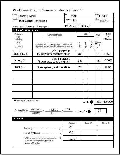
After transferring the basin area from the USGS quad map onto the soil survey map, the areas of different soil groups can be planimetered and grouped according to land cover/use. From Table 2-2 in the TR-55 publication, the appropriate RCN can be determined for each area.
Storage in lakes, ponds, and swamps, ST, can be estimated similarly to forested areas from the USGS quad map. The value is used as the percentage of the basin of interest. Using an engineer's scale, areas shown with the water body or swamp symbol can be resolved by eye into equivalent rectangles or triangles, measured, and area calculations accumulated in memory in a hand-held calculator. Large contiguous areas can be planimetered and summed the same way as forested areas. On the example basin delineated below containing 1,115 acres, starting with the large pond and moving clockwise, the areas were estimated as: 1,000'x300'=300,000 sq. ft.; 150'x100'=15,000 sq. ft.; 1,000'x500'=500,000 sq. ft.; 500'x150'=75,000 sq. ft.; 700'x600'=420,000 sq. ft.; 500'x100'=50,000 sq. ft.; and 500'x100'=50,000 sq. ft. As each area is estimated, it is advisable to mark it with a small checkmark to assure all areas are measured and none are double counted. Summing, the total gives 1,410,000 sq. ft., which divided by 43,560 sq. ft. per acre gives 32.4 acres. ST can then be calculated by (32.4/1,115) 100 = 2.9%.

Previous Bulletin Topics
- Introduction to the NFF Program and USGS regression equations, the applicability of the regression equations, and the advantages and limitations of the regression equations
- Use of USGS regression equations in the NFIP and Criteria for using USGS regression equations in the NFIP
- Revisions to the USGS regression equations since the NFF software was released
- Part 1. Unusual parameters of USGS regression equations and how to obtain them
Upcoming Bulletin Topics
- Unusual Parameters of USGS Regression Equations and How to Obtain Them
- Examples in which USGS regression equations are used for NFIP purposes
Click here to view the archive page for all Flood Hazard Mapping listservs.
Last Modified: Friday, 22-Jun-2007 11:57:20 EDT