MMAB Sea Ice Analysis Page
A satellite we use in constructing the sea ice analyses is overage and now
providing poor data. This has corrupted the analysis. We are working on
getting better data, but this may not be a speedy process. When we have
confidence in a newer process, it will be announced here. In the mean time,
though figures will continue to be produced, they cannot be relied upon
as formerly. 25 February 2009
High Resolution Ice
Current High Resolution Ice Analyses
Global
Northern Hemisphere
Great Lakes
Laurentian Lakes and Hudson Bay
Sea of Okhotsk and Sea of Japan
Southern Hemisphere
Historic Information (High Resolution)
Global
Great Lakes
Great Bear and Great Slave Lakes
NWS Web distribution disclaimer
Privacy Policy
Join the MMAB Mailing List
Old Resolution Today's Ice
Interpreting the Images
How the ice grids are constructed
Details on the regional images
The current sea ice state is important for both modeling efforts,
such as the sea ice model and the global weather model, and for sea ice
analysts, such as at the Anchorage
WSFO. Consequently we produce two sorts of field. One is suitable for
use by models, the global field. And the other is suitable for use by an
analyst. The analyst can apply intelligence and additional data sources
to produce a superior final product in his area of responsibility.
For suggestions on the interpretation of these images, please click
on the word advice
here. For more detail on the source of the images, select the 'about' link
below. For much more detail on the data source, quality control, and processing
methods, see the Automated
Passive Microwave Analysis ... document.
Sea ice history and climatology information, including animations of
the ice cover, is
at http://polar.ncep.noaa.gov/seaice/Historical.html
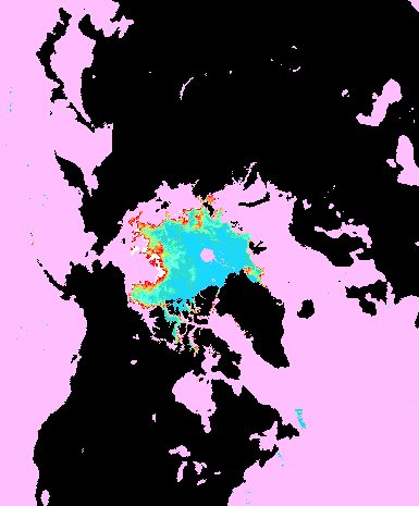
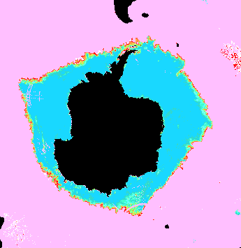
The Northern Hemisphere and Southern Hemisphere ice concentration
images are live maps. If you select a point on these images, you'll get
a magnified image of the region for about 550 km (300 nautical miles) around
that point. The orientation of the maps may be different from the full
hemisphere image. Please click
here for an explanation.
Please e-mail errors or additional analysis sites to
Robert.Grumbine@noaa.gov
Last Modified 25 February 2009
Most Recent NCEP Automated Ice Concentration Fields
Interpreting the Images
Previous Alaska Region Maps
NCEP MMAB Interactive Sea Ice Image Generation
Animation Alaska Region
Sea of Okhotsk and Sea of Japan - current figure
Click on a point in the northern hemisphere map to get a magnified view of
ice in that vicinity.
Animated Northern Hemisphere
NCEP MMAB Interactive Sea Ice Image Generation
Click on a point in the southern hemisphere map to get a magnified view of
ice in that vicinity.
Global ice cover as used for numerical weather, wave, and ocean prediction.

Sea Ice Daily Analyses and Images
More about the sea ice group
Links to other polar work
Return to main sea ice page
Return to MMAB products page
Return to Marine Modeling and Analysis Branch main page
Reciprocal Links -- pages that reference the MMAB sea ice page, so might also be of interest
