|
|
.
|
Researching the effects of underwater hydrothermal venting systems |
 |
|
 |
|
 |
|
 |
|
 |
|
 |
|
|
| Lau Basin | ||||||
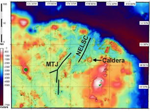
2008 Expedition to Lau Basin R/V Thompson Plume Discovery-Expedition Update:
Voyage TN227 of the R/V Thompson is presently conducting seafloor mapping and water-column plume surveys in the NE Lau region. We are currently over the NE Lau Spreading Center at ~15 deg 24’S, 174 deg 15’W. We have found that the water column over this back-arc spreading center is populated with an unusual suite of spectacular plumes at depths ranging from 1400 m up to 700 m below the sea surface. Some of our water column profiles detected over 5 distinct hydrothermal plume layers, and the shallowest of these plumes is over 600 m above any local topography. Furthermore the plumes are characterized by intense light scattering anomalies, high Eh signals, and in some cases very high concentrations of dissolved hydrogen. This represents a considerable increase in activity compared to the previous study conducted here on the R/V Kilo Moana in 2004 [German et al., g-cubed, 2006], and a suite of plume surveys conducted using IMI30 and MAPRs in July 2008. Based on our collective experience, these plumes have the physical and chemical characteristics associated with seafloor eruptive activity. During the remaining 6 days of this expedition, we plan to continue surveying the region and attempt to localize the source of this unusual activity. We had considered deploying Dan Fornari's camera system, which is also on board, but not all of the necessary components are on the ship. We ! believe The RIDGE community should consider this site as a focus for future Time Critical Studies activities, especially in conjunction with ship operations supporting the Lau ISS. All updates from sea are be posted at: More Information:
updated 10/9/2008 |
||||||