

You are here: Home › Stressors › Extreme Events › Harmful Algal Blooms › Feature Stories › Modeling Needs Identified for Ecosystem-Based Management in the Gulf of Maine
Modeling Needs Identified for Ecosystem-Based Management in the Gulf of Maine
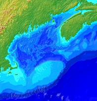
The Gulf of Maine contains rich habitats that are affected by many human activities. To facilitate the coordination of marine research and monitoring in and around the Gulf of Maine, NOAA's Center for Sponsored Coastal Ocean Research supported the Modeling Needs Related to the Regional Observing System in the Gulf of Maine workshop in July, 2005. One in a series of workshops coordinated by the Regional Association for Research on the Gulf of Maine, it provided a venue to identify management needs for modeling and prediction in relation to the emerging regional observing systems in the Gulf of Maine. The broad scope of the workshop brought together resource managers and marine research scientists from many disciplines. The workshop report is now available online, click here to view. To view PowerPoint presentations and posters presented at the meeting, click here. For more information, please contact Elizabeth.Turner@noaa.gov