- Cadastral
Introduction
The Cadastral category page provides a listing of the most relevant metadata records of information pertaining to interests in real property or used in planning and development efforts.
Links
Content Summary: This is the link to the home page for the FGDC Cadastral Subcommittee that includes all standards, projects and documents that are related to the development of the Cadastal NSDI
Go to websiteContent Summary: This is the list of all Cadastral Subcommittee Standards
Go to websiteLive Data and Maps
Content Summary: This site provides a map based index of states, counties and cities that serve cadastral or parcel level information on their web sites. Some of these data are free, some have a fee and some are for browsing only. The data ranges from parcel maps to assessment and value information to recording documents
Content Type: Clearinghouses
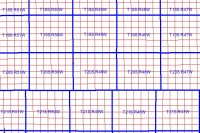
Content Summary: This interactive map application links the Montana Cadastral Database to the MT. Dept. of Revenue CAMA database for interactive discovery of property information. The Montana Cadastral Database is comprised of taxable parcels (fee land) and public land(exempt property). It is not broken down into individual lots, for instance lots 4 & 5, Forest Grove Subdivision may comprise one taxable parcel and the lot line between lots 4 & 5 is not contained in this database. The database will eventually encompass all the area and is 99% complete as of 9/21/05. The data is housed within an ARCPARCEL geodatabase model in ARCSDE. Each parcel contains an attribute called geocode that is the parcel identifier. It relates to the geocode in the Montana Dept. of Revenue Computer Assisted Mass Appraisal (CAMA) database. Most of the ancillary attribute information is held in this database. Information such as owner name, legal description, appraised value as well as structural and agricultural data are available within CAMA. Raw flat files of county CAMA data (by County) are available for download at the project website listed above. Data is built upon the USDI Bureau of Land Management's (BLM) Geographic Coordinate Database (GCDB). The GCDB is a complex measurement management system that uses a least squares adjustment of existing survey data to come up with a digital representation of the Public Land Survey System (PLSS). For more information on GCDB you should proceed to the Montana/North Dakota BLM website at http://www.mt.blm.gov/cadastral/gcdb. Accuracy varies between townships and it is important to note that the accuracy of the parcel data can't be any more accurate than the GCDB. NOTE - even though scale denomination is said to be 1:12,000 the accuracy of the parcels varies because of the variable accuracy of GCDB
Content Type: Live data & maps
Content Summary: National Integrated Land System (NILS) - Land Survey Information System is the official federal government website for the distribution of the Public Land Survey System - PLSS of the United States and other survey-based data for the federal government. The spatial data layer is from the BLMs National Integrated Land System (NILS) and is based on BLMs Geographic Coordinate Data Base (GCDB) coordinate data. The data can be downloaded from GeoCommunicator (www.geocommunicator.gov) as GIS shapefiles and includes township, section, and subdivision of sections. Metadata is available from the GeoCommunicator website. Data from the U.S. Forest Service and other federal, state, and local agencies is available as alternate source data. Website: http://www.geocommunicator.gov, Map server: http://www.geocommunicator.gov, Service Name:BLM_MAP_PLSS or BLM_LSIS_wms
Content Type: Live data & maps
Content Summary: The MMS is making its existing cadastre data available at http://www.mms.gov/ld/Maps.htm. These data will include digital images of MMS data at the regional, planning area, Official Protraction Diagram (OPD), and Supplemental Official OCS Block Diagram (SOBD) levels and digital spatial data in Arc/Info export and Arc/View shape format at the regional or planning area levels.
Content Type: Clearinghouses
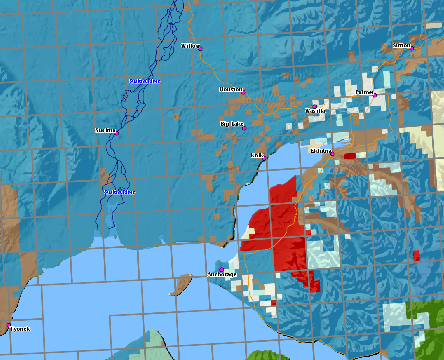
Content Summary: The Spatial Data Management System has been developed to provide Internet access to BLM Alaskas land information. This system supports the E-GOV initiative in providing the public access to government records.
Content Type: Live data & maps
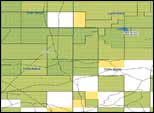
Content Summary: The National Integrated Land System (NILS)- Land and Minerals Use Records is an Internet mapping application and map service showing the BLM issued land and mineral use authorizations, such as: oil and gas leasing, mineral (coal, potash, etc) leasing, mining claims, conveyances, land exchanges, rights-of-way and more. For each use authorization parcel users can link directly to the BLMs LR2000 system to get up-to-date reports such as serial register pages.
Content Type: Live data & maps
Content Summary: The BLMs Land and Mineral Records System (LR2000) provides access to BLM oil, gas, geothermal, coal, and other mineral leasing, rights-of-way grants, mineral material, land title, non-mineral leasing/permitting, and land/mineral withdrawals and classifications that are issued or authorized by the BLM. The LR2000 system also includes unpatented mining claims occurring on federal lands.
Content Type: Applications
Content Summary: The General Land Office site provides access to Federal land conveyance records for the Public Land States and image access to more than three million Federal land title records for Eastern Public Land States, issued between 1820 and 1908. Images of Serial patents (land titles issued between 1908 and the mid-1960's) have been added to this web site. Images related to survey plats and field notes, dating back to 1810, are added to the site state-by-state as each state's documents are completed. Due to organization of documents in the GLO collection, this site does not currently contain every Federal title record issued for the Public Land States.
Content Type: Applications