Pacific Northwest Pilot
 Pacific Northwest Pilot Program
The Coastal Storms Program is a nationwide effort led by the National Oceanic and Atmospheric Administration (NOAA) to lessen the impacts of storms on coastal communities. To accomplish this goal, local, state, and federal organizations are working together on site-specific projects.
How does the Coastal Storms Program Work?
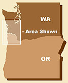
The program’s Pacific Northwest pilot, which began in 2003, is a compilation of tools that address specific hazards-related issues. Taken together, the tools will result in a large suite of new and improved data, information, forecast models, and training for coastal communities. The geographic area of the pilot covers portions of the Lower Columbia River, the Northwest Oregon coast (to Tillamook Bay), and the Southwest Washington coast (to Grays Harbor). The tools being developed and deployed include the following:
The Coastal Storms Program has already completed a pilot in the St. Johns Watershed along Florida’s northeastern coast and has begun a third pilot in Southern California.
What Does This Program Hope to Accomplish?
Currently, more than half the population of the U.S. lives in the coastal zone. The Coastal Storms Program seeks to ensure the safety of this population and sustain the natural environment, which in turn will promote a healthy economy. As a result of the products and services developed for this project, local communities will better be able to predict and reduce the impacts of coastal storms, saving lives, property, and money.