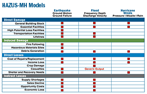
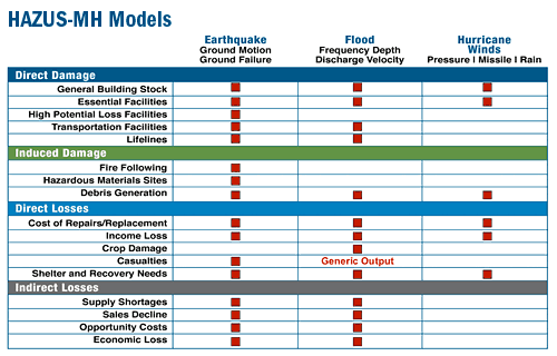
HAZUS-MH Models
 HAZUS News e-mail updates
The HAZUS-MH MR3 Hurricane Wind Model allows users in the Atlantic and Gulf Coast regions and Hawaii to estimate hurricane winds and potential damage and loss to residential, commercial, and industrial buildings. It also estimates direct economic loss, post-storm shelter needs, and building and tree debris quantities and allows assessment of specific structural changes to buildings to strengthen them for mitigation. The model has the capability to define hurricane scenarios using National Weather Service forecasts/advisories and the software is optimized for rapid loss assessment. New MR3 features for the Hurricane Model include mitigation analysis options for all of the building classes and thousands of new damage and loss functions in the database. Tree debris can be estimated by weight or volume likely to be collected and disposed of using public funds. An "Automatic Outputs" tool added to the Hurricane Analysis Options dialog allows users to specify a standard set of results that will be automatically generated after each scenario or probabilistic analysis. A new rapid loss feature has been added that generates a range of potential damage and loss estimates for a given hurricane forecast that are included in the rapid loss summary report. Details about the Hurricane Wind Model.
The HAZUS-MH MR3 Flood Model can be used to assess both riverine and coastal flooding and estimates potential damage to buildings, essential facilities, transportation lifelines, utility lifelines, vehicles, and agricultural crops. The model addresses building debris generation and shelter requirements. Direct losses are estimated based on physical damage to structures, contents, and building interiors. The effects of flood warning are taken into account, as are flow velocity effects. New MR3 features include improved integration with the underlying ArcGIS platform and an option to create study regions larger than four counties using the full version of SQL Server. Details about the Flood Model.
Additionally, HAZUS-MH can perform multi-hazard analysis by providing access to the average annualized loss and probabilistic results from the hurricane wind, flood, and earthquake models and combining them to provide integrated multi-hazard reports and graphs. HAZUS-MH also contains a third-party model integration capability that provides access and operational capability to a wide range of natural, man-made, and technological hazard models (nuclear and conventional blast, radiological, chemical, and biological) that will supplement the natural hazard loss estimation capability (hurricane wind, flood, and earthquake) in HAZUS-MH.
A unique feature of HAZUS-MH is the national inventory that comes with the model. Inventory data includes 1) Essential Facilities: police, fire, emergency operations facilities, schools, medical facilities; 2) Lifelines: utilities and transportation; 3) General Building Stock: residential, commercial, and industrial (aggregated by square footage); and 4) Demographic Data, which can be aggregated by age, income, sex, households and other attributes that have a direct bearing on vulnerability to disasters. Read more about HAZUS-MH Inventory Potential Applications.
One of the truly unique attributes of HAZUS-MH is the national inventory of hazard data, “point data” (e.g., essential facilities) and aggregated data on the general building stock. The Summary of HAZUS-MH Databases provides a very useful reference for these databases.
Find additional information about HAZUS-MH in the HAZUS Resources, such as:
Last Modified: Wednesday, 20-Aug-2008 14:50:14 EDT
Fast Facts
Potential loss estimates analyzed by HAZUS-MH include physical damage to residential and commercial buildings, schools, critical facilities, and infrastructure; Economic loss, including lost jobs, business interruptions, repair and reconstruction costs; and Social impacts, including estimates of shelter requirements, displaced households, and population exposed to scenario earthquakes, hurricane winds, and floods.
References
- HAZUS-MH Hurricane Wind Model Validation Study--Florida
- HAZUS-MH for Mapping Decision Makers Poster
- HAZUS-MH Order Form