|
|

|
Archives
Home Page Stories
-
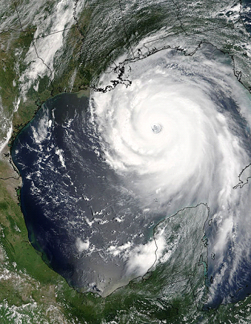
NOAA Takes Stock of Restoration Projects After Recent Hurricanes
In the wake of Hurricanes Ike and Gustav, scientists and coastal restoration
biologists have just begun to assess the storm's impacts on the Gulf Coast.
How did the projects survive on the beaches, wetlands and barrier islands? Were
they damaged beyond repair? Or, did they actually serve their intended purpose?
Under natural conditions, coastal ecosystems rebound quickly after hurricanes
and even help flush marshes and estuaries of pollutants and stagnant
water.Coastal habitats also absorb storms' energy, a scenario made very real
each time a hurricane makes landfall unimpeded by the former marsh and barrier
islands that had once protected the coast.
In Texas, where Ike made landfall, early reports on a number of projects aimed
at protecting shorelines nearby Galveston Island held their structural
integrity and projected adjacent marshes and surrounding areas. Unfortunately,
aerial photography of the Galveston area also shows numerous oil releases
affecting coastal salt marshes, as well as near and offshore waters. As these
spills are identified and characterized, NOAA's DARRP Program, in conjunction
with state partners, are attempting to reach high priority spill areas by boat
and to begin assessment of natural resources.
As the results of Hurricane Gustav and Ike continue to unfold, state and federal
agencies are working to determine the best way to fully analyze the impacts of
these storms.
-
Delaware Wetland Site a "Restoration Success," Say Experts
On October 2, NOAA and its partners- the U.S. Fish and Wildlife Service,
Delaware's Department of Natural Resources and Environmental Control, and the
U.S. Army Corps of Engineers- will celebrate the completion of a
restoration project in Milford, Delaware. This project restored more than
2,200 feet of shoreline and protected 56 acres of neighboring land.
The site is located on the banks of the Mispillion River, an important
tributary of the Delaware River. Its significance is its role in providing
habitat for migratory fish.
Using settlement funds, NOAA and its partners and trustees began working
cooperatively to complete the restoration. Natural-fiber logs were placed at
the water's edge, reducing shoreline erosion and stabilizing shoreline. In
tidal marsh areas, a channel was cut to allow fish to swim through and reach
their spawning and rearing habitat. Shallow pools were also created, which
improved tidal flushing and created additional spawning areas. These pools will
increase salinity in the marsh, which will help to control the growth of an
invasive grass species called Phragmites
.
The site is one of the restoration projects funded by DuPont as compensation
for injuries to natural resources from contamination from the DuPont Newport
Superfund Site, 55 miles upstream in the Christina River watershed.
For more information about this project, see the
DuPont Newport case or contact Carl Alderson at
Carl.Alderson@noaa.gov.
-
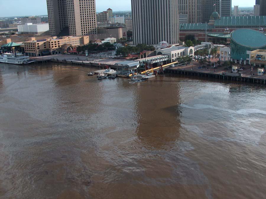
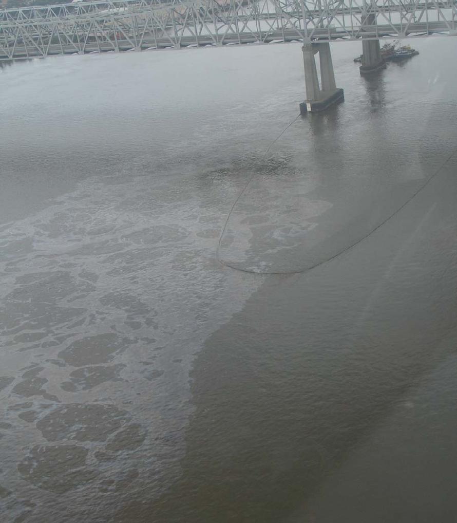
NOAA Continues to Investigate Resource Impacts for Oil Spill in New Orleans
On July 23, a 600-foot chemical tanker and 200-foot fuel barge collided on the
Mississippi River. The barge was torn in half, spilling several hundred
thousand gallons of fuel oil into tthe river near the French Quarter in
downtown New Orleans. The released oil spread 100 miles down the Mississippi
River, resulting in injury to roughly 200 miles of shoreline.
After more than five weeks, NOAA staff are still working with other federal and
state agencies (collectively known as the "Trustees") on pre-assessment
activities at the spill site. Recent field activities have been focused on
shoreline cleanup and the evaluation of bottom sediments in the Mississippi
River where oil from the barge may have been deposited. Of the 198 miles of
shoreline that have been assessed for oiling and cleanup by response personnel,
84% is considered clean. The remaining shoreline under active cleanup is
primarily rip-rap habitat in highly visible area. The Trustees will use
information from the cleanup in combination of aerial and ground habitat oiling
surveys, as well as other information, to determine whether injuries to natural
resources and services occurred from the incident. The assessment activities
occurring in the New Orleans area also will inform approriate restoration
activities to compensate the public for any loss of natural resources resulting
from the spill.
Any eventual restoration project resulting from this spill will contribute to
addressing the larger challenge of protecting and restoring Louisiana's coastal
ecosystem, which is losing an estimated 24 square miles of coastal wetlands a
year.
According to the U.S. Coast Guard, there were an average 1,500 reported oil
spills a year in Louisiana between 1991 through 2004, or about four reported
spills a day. This is in part due to the large volume of oil and gas which pass
through Louisiana's coastal zone: a network of nearly 9,300 miles of oil and
gas pipelines and associated energy facilities are located there. Another major
factor that contributes to the large number of spills is Louisiana's receding
wetlands, which increase exposure of this aging infrastructure to natural and
man-made threats (e.g., tropical storms and vessel collision).
For more information about the Louisiana oil spill, please contact Rachel
Brittin at Rachel.Brittin@noaa.gov
or Michael Jarvis at Michael.Jarvis@noaa.gov.
-
Recent Boat Tours Highlight NOAA's Protection and Restoration Efforts
On August 11, staff from the U.S. House of Representatives
Science Committee, the Offices of Senator Maria Cantwell and
Representative Norm Dicks joined staff from NOAA's Damage Assessment,
Remediation, and Restoration Program (DARRP), NMFS Northwest Region, NMFS
Montlake Lab, and NOAA Legislative Affairs for a boat ride across Puget Sound,
a tour of the NMFS Manchester Lab, and a boat tour of South Elliott Bay, and
the Lower Duwamish River, WA. On a second boat tour held that same week, DARRP
and NOAA partners hosted Vice Admiral Conrad C. Lautenbacher, Jr., Under
Secretary of Commerce for Oceans and Atmosphere and NOAA Administrator and
David A. Sampson, Deputy Secretary of the Department of Commerce. The goal of
these events was to provide a short overview of NOAA activities in Puget Sound
and how these efforts are coordinated with other Federal and State agencies.
On each of the two tours, the attendees were given an overview of NOAA's
responsibilities under the Comprehensive Environmental Response, Compensation,
and Liability Act (CERCLA or Superfund) and the Oil Pollution Act (OPA) - from
response and assessment and ultimately through negotiations and restoration of
the public's injured natural resources. The tour also highlighted a number of
Superfund sites where NOAA is assessing injury along the river, including the
East Waterway and Lower Duwamish River sites, where NOAA is providing advice on
cleanup approaches and negotiating compensatory restoration. For more
information, please contact Jennifer.Steger@noaa.gov
or Mary.Baker@noaa.gov.
-
Suisun Bay Reserve Fleet Assessment Project
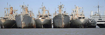 |
Congress requested NOAA to evaluate the potential environmental impact of the
federally owned vessels in Suisun Bay, California. These vessels are maintained
by the United States Maritime Administration and include more than 70 obsolete
or decommissioned ships, sometimes referred to as the "Reserve" or "Mothball
Fleet."
The State of California and several bay area environmental groups have raised
concerns about the environmental impacts, and plans to move the vessels through
San Francisco Bay for eventual scrapping and disposal. Issues range from the
potential presence of heavy metals in paint that is peeling and falling off, to
antifouling agents used in bottom paint on the hulls, to PCBs and other
hazardous materials that may have been released from the ships.
NOAA will be conducting a field investigation and preparing documents to help
address these concerns.
Read more about the Suisun Special Project
for more information, or view the latest, October
2008 Status Report
-
LAND GOES BACK TO NATURE
Alcoa creates marsh that will be donated to Aransas refuge
March 29, 2007
By Louise Popplewell - Victoria Advocate

Reprinted by permission.
PORT LAVACA - In giving back what it took away so many years ago, Alcoa on
Wednesday showed off its latest project to restore Lavaca Bay, and federal,
state, county and local officials were on hand to celebrate with Calhoun County
residents.
The culmination of 15 years of work by so many drew to a close with completion
of Alcoa's creation of a 70-acre inter-tidal marsh on 730 acres near Indianola
the industrial giant acquired and will transfer to the Aransas National
Wildlife Refuge.
The addition to the 3,400-acre Myrtle Foester Whitmire Unit of the refuge
consists of marsh habitats and Powderhorn Lake that are viewed from a 30-foot
man-made elevation.
The improvements were made as part of the terms of a settlement to resolve the
company's liability for damages stemming from releases of mercury and
hydrocarbons into the bay in the late 1960s.
read more
-
NOAA and Its Partners Publish Two Louisiana Restoration
Planning Documents
The National Oceanic and Atmospheric Administration is pleased to
announce the publication of two Louisiana Regional Restoration Planning Program
(RRP Program) documents. NOAA and its natural resource co- trustees have
developed the innovative statewide comprehensive RRP Program to respond to oil
discharges.
The framework and the major provisions of the RRP Program are outlined in a
Final Programmatic Environmental Impact Statement (FPEIS) . The FPEIS
divides the State of Louisiana into nine regions and a Regional
Restoration Plan for each will identify trust resources and services that
are likely to be injured by an oil spill, suitable restoration for those
injuries, and available projects that can be implemented at the local level to
affect restoration. The first of these plans, the
Final Regional Restoration Plan for Region 2, is available for the
delta region of southeast Louisiana.
NOAA Restoration Portal
The NOAA Restoration Portal
has been updated to provide you with more information about NOAA's vital
restoration projects. The enhanced site now provides comprehensive information
about restoration techniques, NOAA restoration programs, projects, and
activities, and access to the other NOAA restoration resources. The site also
provides educational resources, a publication library, and a list of funding
sources.

Team sampling marsh sediments
and water quality near a creek restoration project.
-
NOAA Leading Assessment of Areas Possibly Harmed by Citgo Oil Spill
Workers with the National Oceanic and Atmospheric Administration are leading a
federally mandated assessment of areas possibly harmed by the June 18, 2006
Citgo oil spill. That process, called a national resource damage assessment, is
a long-term effort involving several government agencies and led by NOAA.
Its goal is to quantify the damage to sensitive areas of the environment, such
as river bottoms and wetlands. State environmental and health regulators have
begun testing tissue samples from fish, shrimp, crabs, and oysters for any
effects from the spill.
*Reprinted with permission from the American Press.

|
|
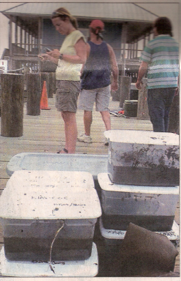 |
| Captain Scott Wyatt of Pathmaker Airboats from Cecilia arrives at
Calcasieu Point along with crews from the National Oceanic and Atmospheric
Administration and other agencies. The group was bringing in sediment samples
from Big Lake. Testing is being conducted as a result of the recent Citgo oil
spill. Crews with NOAA will be collecting samples throughout the affected areas
for two weeks. |
|
Lisa Dipinto of NOAA checks for phone calls at Calcasieu Point
after she collected sediment samples from Big Lake. |
-
 Bald Eagle Chick
Takes Its First Flight Bald Eagle Chick
Takes Its First Flight
After weeks of practice, the first bald eagle to hatch on the northern Channel
Islands in over 50 years took to the air in its first flight July 14, 2006.
This bald eagle reintroduction study is part of the
Montrose Settlements Restoration Program , a
multiagency effort to address natural resource injuries from DDT and PCB
releases into the environment by Montrose Chemical Corporation and other
industrial sources in Southern California in the mid 20th century. Closeup
views from a publicly broadcast web camera and play-by-play posts from an
associated discussion board allowed hundreds of people to join biologists as
they watched the chick show typical preflight behaviors over two weeks. There
were at least 32 news sources that had reported it; 200 registered users were
documented on the webcam; and at least 450,000 hits were sited on the website.
Home Page What's New
Fact Sheets
Press Releases
-
May 23, 2007: NOAA's Damage Assessment,
Remediation and Restoration Program Celebrates 15 Years of Success
-
March 28, 2007: Lavaca Bay Restoration and Clean Up
Celebrating Successful Government-Industry Partnership
-
December 17, 2003: NOAA and Florida Awarded $2.2
Million for South Florida Oil Spill
-
September 17, 2003: Agencies Seek
Input on Draft Regional Restoration Plan for Louisiana
-
September 10, 2003: Restoration Begins for Westchester
Oil Spill in Louisiana
-
June 18, 2003: First State-Wide Program
Promotes Regional Restoration in Louisiana
-
January 8, 2003: NOAA and Florida Submit $2.2 Million
Claim for South Florida Oil Spill
-
December 12, 2002: NOAA
Announces $2.7 Million Patuxent River Oil Spill Restoration
-
December 22, 1999, press release
announcing that a "settlement in principle" had been reached in the North Cape
oil spill.
-
Press Release issued July 6,
2000—"U.S., Rhode Island announce settlement to redress environmental damage
from massive oil spill"
|
|
|