Mississippi Katrina Flood Recovery
- About Mississippi Katrina Flood Recovery Maps
- Mississippi Flood Recovery Maps
- Geographic Information System (GIS) Data
- Recovery and Mitigation Resources
About Mississippi Katrina Flood Recovery Maps
Hurricane Katrina made landfall on August 29, 2005, in southeastern Louisiana, with maximum sustained winds of 140 mph. Hurricane-force winds extended outward up to 105 miles from the center of the storm. Coastal storm surge flooding of 20 to30 feet above normal tide levels, along with large and dangerous battering waves, occurred near and to the east of where the center of the storm made landfall. Widespread damage occurred, including beach erosion and damage and/or destruction of homes and infrastructure. more...
Mississippi Flood Recovery Maps
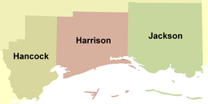 Maps showing the extent and magnitude of Hurricane Katrina's surge, as well as information on advisory flood data, were created for the areas of Harrison, Hancock, and Jackson Counties in Mississippi that were most severely impacted by coastal flooding. more...
Geographic Information System (GIS) Data
GIS is used to display and analyze spatial data that are tied to databases. The Katrina Recovery Maps were developed using GIS. Several data layers from the Katrina Recovery Maps are available as GIS shapefiles for download. To download the GIS data, click on one of the links below. Please refer to Mapping Methods and Data Sources page for more information on the development of these data.
- Geographic Information System (GIS) Data
Recovery and Mitigation Resources
Links and other resources have been provided to various Federal, state, and local agencies involved in Hurricane Katrina response and recovery activities.
Download Plug-in
Some of the links on this page require a plug-in to view them. Links to the plug-ins are available below.
Last Modified: Monday, 19-May-2008 17:18:13 EDT