Hurricane Rita Surge Inundation and Advisory Base Flood Elevation Maps
Vermilion Parish, Louisiana
FEMA has developed Hurricane Rita Surge Inundation and Advisory Base Flood Elevation Maps (referred to as, “Rita Recovery Maps”) to aid Vermilion Parish property owners to repair or rebuild structures to newly determined advisory coastal flood elevations. These maps are based on Flood Recovery Guidance for Vermilion Parish (PDF 118KB, TXT 10KB) that FEMA published in November 2005.
Frequently Asked Questions
- How do I find the Rita Recovery Map that shows my property?
- How do I determine what Advisory Base Flood Elevation (ABFE) applies to my property?
- I know my ABFE. How high above ground does this mean I have to elevate my structure?
- How did FEMA determine what areas got flooded by Hurricane Rita’s storm surge, and should I be concerned if I think the surge limits are inaccurate?
How do I find the Rita Recovery Map that shows my property?
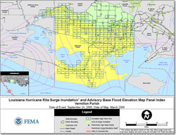
To locate a particular property, the first step is to determine which detailed Rita Recovery Map panel applies to the area of interest. Users should first consult the Vermilion Parish Index Map (PDF 1.0MB), which shows which panels were produced and what area is covered by each. Panel numbers are shown in green text (e.g., PP25). Panels were only produced for areas where structures or other significant development could be observed on recent aerial photography.
Once the detailed Rita Recovery Map panel number is known, it can be opened by clicking on the corresponding panel number on the parish map immediately below. The panel will open up in the internet browser window using the Adobe Acrobat Reader software. The Rita Recovery Map panels range in size from 1.1 MB to 2.3 MB.


Rita Recovery Maps are for advisory purposes only; they do not supersede effective Flood Insurance Rate Maps (FIRMs). The Hurricane Rita-related data presented are preliminary and subject to update as additional data become available.
How do I determine what Advisory Base Flood Elevation (ABFE) applies to my property?
The Rita Recovery Maps depict ABFEs (that is, elevations that FEMA recommends be used for rebuilding) for defined areas or zones. The visual appearance of these advisory zones and elevations was intentionally made similar to the format of flood hazard data shown FEMA’s FIRMs. [Note: Individuals unfamiliar with FIRMs can view the online tutorial, “How to Read a Flood Insurance Rate Map (FIRM).”]
On the Rita Recovery Maps, each ABFE zone is outlined in yellow and is labeled with the applicable advisory flood zone type and whole-foot elevation (e.g., ABFE Zone VE Elevation 16). ABFEs are measured relative to the National Geodetic Vertical Datum of 1929 (NGVD29), or roughly sea level. The whole-foot ABFE listed on each contour can be directly applied to properties located within the zone. On some maps, a thick yellow line marks the inland limit of the ABFEs; landward of this line, ABFEs do not apply.
I know my ABFE. How high above ground does this mean I have to elevate my structure?
Since the ABFEs are measured relative to NGVD29 (or roughly sea level), property owners will need ground elevations to determine how high above grade a structure should be elevated to meet the ABFE. Property owners are advised to consult with a licensed surveyor or professional engineer to determine ground elevations at their site. Once the ground elevation is known, it can be subtracted from the ABFE to calculate the height above grade that a structure’s first floor (in A Zones) or lowest horizontal structural member (in V Zones) should be elevated.
How did FEMA determine what areas got flooded by Hurricane Rita’s storm surge, and should I be concerned if I think the surge limits are inaccurate?
FEMA used the best data available at the time the recovery mapping was completed to estimate the extent and magnitude of Hurricane Rita’s storm surge. To develop this data layer, surge-only High Water Marks (HWMs) collected by FEMA shortly after the storm were compared to detailed, pre-storm topographic data provided by the State of Louisiana. In some areas, few or no HWMs were available to help guide the mapping; in these cases, surge inundation limits were interpolated from more distant HWMs, with coastal engineering judgment and eyewitness accounts (when available) used to complete the mapping. As a result of these and other data limitations, the mapped Rita surge limits may over- or underestimate the actual coastal flooding that occurred.
The ABFEs, not the estimated Rita surge limits or surge heights, are what FEMA is advising be used for rebuilding, so there should be no negative impact on property owners if the Rita limits were over- or underestimated. If property owners have detailed documentation concerning the height and/or extent of Rita’s surge flooding that differs from the data shown on the Rita Recovery Maps, they can submit this information through the recovery mapping helpline link listed below. Unless there becomes a need to completely reanalyze the Rita surge and remap large areas, FEMA will only be able to use submitted information to help improve the surge inundation modeling and mapping procedures for future recovery mapping efforts.
Download Plug-in
Some of the links on this page require a plug-in to view them. Links to the plug-ins are available below.
Last Modified: Monday, 06-Nov-2006 16:56:18 EST