Three rivers were affected by a December 22, 2008 spill of 5.4 million cubic yards of coal combustion waste mixed with water that escaped from a 40 acre settling pond after breaching an earthen dam. The slurry flooded 300 acres and entered the Emory River, a tributary of the Clinch River, which flows to the Tennessee River. The slurry of coal combustion waste and water was produced by the Tennessee Valley Authority's
Kingston Fossil Plant, which discards the slurry in settling ponds adjacent to the facility. Located in East Tennessee, the facility has been operational since 1955 and provides 10 billion killowatt-hours of electricity each year, burning 14,000 tons of coal a day and powering 670,000 residences according to
TVA figures.
This page contains information about response to the spill. It also provides access to maps and satellite imagery of the Kingston Steam plant and the impacted rivers as well as publications, journal articles, and news related to coal combustion waste in general and the Kingston Fossil Plant ash pond dike failure in particular.

[Photo: U.S. Environmental Protection Agency, On-Scene Coordinator]
View of coal combustion waste slurry spill's impact to land adjacent to breached settling pond. Kingston Fossil Plant, Clinch River, and Additional settling ponds are visible in the distance. For additional photos, click here.
|
|
|
Geographic Perspectives of the Kingston Fossil Plant Coal Ash Spill
|
 [Image: Tennessee Valley Authority]
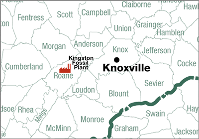
The map above shows the location of the Kingston Fossil Plant in East Tennessee. Advanced maps of the site are available from the mapping services at left.
|