Hurricane Katrina Flood Recovery (Louisiana)
- Base Maps
- Hurricane Katrina Preliminary High Water Marks
- Hurricane Katrina Surge Inundation Limits
- Advisory Base Flood Elevations (ABFEs)
- Hurricane Katrina Surge Elevation Contours
Mapping Methods and Data Sources
The Hurricane Katrina Surge Inundation and Advisory Base Flood Elevation Maps (or “Katrina Recovery Maps”) show a variety of information concerning the hurricane's impact – information that was developed through numerous post-storm surveys and data analyses. The Katrina Recovery Maps also show Advisory Base Flood Elevations (ABFEs), which are the best 1%-annual-chance (100-year) coastal flood elevations currently available to guide redevelopment along the Louisiana Gulf Coast.
The data sources and analysis methods used to develop the Katrina Recovery Maps are described in the sections that follow. A more detailed discussion of the data and methods is provided in a summary report, “Hurricane Katrina Surge Inundation and Advisory Base Flood Maps - Summary of Methods” (PDF 121 KB) (TXT 20 KB) (last updated June 09, 2006).
Base Maps
The base map for the Katrina Recovery Maps in Mississippi is pre-storm, digital orthophotography that was provided by U.S. Department of Agriculture's National Agriculture Imagery Program.
Hurricane Katrina Preliminary High Water Marks
 Within days of the storm, field observers and survey crews were deployed by FEMA and various state and local governments to interview residents, find evidence of coastal high water levels, take digital photographs, and survey coastal high water marks (HWMs) from Hurricane Katrina. These field crews collected detailed information about each HWM, including physical basis of the mark, such as a mud line inside the building, a mud line on the outside of the building, or debris. Wherever possible, crews also noted the coastal flooding characteristics captured by the coastal HWM, including storm surge, wave runup, and wave height. These designations were based on a combination of physical flood evidence and interviews with witnesses at the time of collection.
The survey crews used static Global Positioning System (GPS) methods to determine an accurate elevation for each coastal HWM. Coastal HWM locations were surveyed horizontally in North American Datum of 1983 (NAD 83), State Plane feet, and vertically in North American Vertical Datum of 1988 (NAVD 88), U.S. survey feet. Coastal HWM locations have been surveyed to within accuracies of 0.25 foot vertically and 10 feet horizontally, with a 95% confidence level. Results from FEMA's HWM surveys will be published and made available to the public and local officials.
Hurricane Katrina Surge Inundation Limits
Flood inundation limits were created for the coastal Louisiana parishes by mapping the coastal HWM elevations onto digital, pre-storm, topographic contour data developed from recent Light Detecting and Ranging (LIDAR) surveys. These inundation limits represent an estimate of the inland extent of flooding caused by Hurricane Katrina's storm surge. In areas where the coastal HWMs were close together but elevations differed significantly (more than 2-3 feet), engineering judgment was used to interpolate the inundation limit between coastal HWMs. At the time of this project, post-hurricane topography was not available for the study area. In addition, inundation limits have only been developed for areas outside of levees.
Please note: FEMA used the best data available at the time this project was completed to develop the Katrina surge inundation limits, including eyewitness observations provided by some local officials and citizens. However, because of inherent variability in HWM elevations, the scarcity of available HWMs in some areas, and small-scale variations in topography, the extent of the surge inundation shown on the Katrina Recovery Maps may over- or underestimate the actual coastal flooding that occurred. Thus, this information should be considered approximate and may be subject to change as additional data become available.
Advisory Base Flood Elevations (ABFEs)
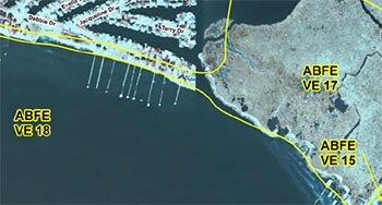 ABFEs were developed to provide communities with recommended building elevations for use in the reconstruction process until more detailed data become available. ABFEs are based on a new flood frequency analysis that takes into account Hurricane Katrina, as well as additional tide and storm data from other events that have occurred during the more than 25 years since the existing Flood Insurance Rate Maps (FIRMs) were developed. For more information on how the ABFEs were determined for each parish, see the Flood Recovery Guidance posted on the Recovery and Mitigation Resources page.
Hurricane Katrina Surge Elevation Contours
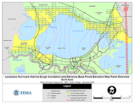 To show regional trends in Hurricane Katrina's coastal surge as the storm came onshore, surge elevation contours were mapped at 1-foot intervals across the southeastern Gulf Coast parishes of Louisiana. These contours are shown on a regional overview map (PDF 754 KB) of the project area.
The Hurricane Katrina surge elevation contours are based upon the surveyed coastal HWM elevations, which were used to find patterns in the coastal storm surge as it pushed against the open coast and into the inland bays. The known path and landfall location of Hurricane Katrina, together with the knowledge of how storm surge propagates inland, allowed surge contours to be drawn across the areas where the coastal HWMs indicate a change in storm surge elevation.
Assumptions are made in some locations to allow the surge elevation contours to “step” up or down at 1-foot intervals. Because of the inherent uncertainty in and the random and irregular spacing of coastal HWMs, the surge contours represent a generalized maximum storm surge elevation, and required professional judgment in their creation. Within certain surge contours, coastal HWMs may be higher or lower than the contours if they did not fit the overall pattern.
Download Plug-in
Some of the links on this page require a plug-in to view them. Links to the plug-ins are available below.
Last Modified: Wednesday, 14-Jun-2006 09:48:04 EDT