Hurricane Ivan Surge Inundation Maps
Okaloosa County, Florida
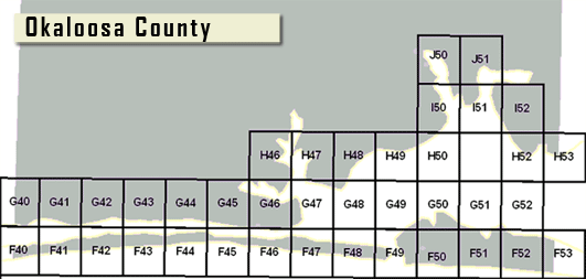
To open an Ivan surge map, click on a numbered map panel below. These files range in size from 0.2 MB to 2.2 MB. For explanation of the features shown on the Ivan maps, please read the “Notes to Users” (PDF 0.03MB, TXT 0.01MB). A map of the county, showing the Ivan map locations, the current FEMA flood map panel locations, and surge elevation contours, can be found in the file, “Hurricane Ivan Surge Inundation Map with Effective FIRM Index – Okaloosa County” (PDF 1.1MB).
Hurricane Ivan Maps are for advisory purposes only; they do not supersede effective Flood Insurance Rate Maps (FIRMs). The Ivan data presented are preliminary and subject to update as additional data become available.
Download Plug-in
Some of the links on this page require a plug-in to view them. Links to the plug-ins are available below.
Last Modified: Thursday, 31-Jul-2008 15:24:38 EDT