|
 Home | Image Galleries | Pollutants in the Environment Home | Image Galleries | Pollutants in the Environment
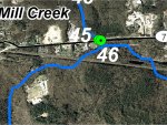
Mill Creek GPS Locations 45 and 46
Locations 45 and 46 are where the south tributary of Mill Creek crosses under Route 7. Mill Creek varies between 2 and 4.5 m (10 and 15 feet) in width at this location. Upstream of the road, the substrate is sand with some angular cobbles. There are trees and shrubs overhanging the water course and there was no indication of erosion on the shallow banks. Downstream of the road, the channel bed is sand and small gravel with some large angular rocks up to 24 inches across. The water had an orange, iron-stained tint. The creek passes under the road through three semicircular arches that do not obstruct fish passage. The owner of a nearby property reported that there were no anadromous fish in this reach of Mill Creek. However, he reported having observed small resident fish of several different species including sun fish, chain pickerel, "small brown fish", and what he described as lamprey eels. In his opinion, beaver dams, further downstream on the creek, were an impediment to fish migration.
Click on an image below to see the full image.
|