Overall compliance with zone restrictions will improve over time.
The results from the zones' effect on the above measures will be considered by managers along with other socio-political factors in deciding the fate of the zones as a management tool.
OVERVIEW OF THE ZONE MONITORING PROGRAM
Goal: To determine by the year 2002 whether the zones are effective in protecting marine biodiversity and enhancing human values related to the Sanctuary. Measures of effectiveness will include the abundance and size of fish, invertebrates, and algae; and economic and aesthetic values of Sanctuary users and their compliance with regulations.
To achieve the goal the following 3-tiered program has been initiated with National Oceanic and Atmospheric Administration/ South Florida Restoration funds (except where noted).
LEVEL I: ECOSYSTEM FOCUS
- Objective: Monitor change in ecosystem structure and function in the largest zones
- Where: Sambos complex (ecological reserve and research-only area) and Carysfort SPA
- What: Coral, lobster, fish, algae, seagrasses and ecological processes (predation, recruitment, and herbivory)
- Who:
- Dynamics of coral reef benthic communities: Dr. John Ogden (project director), Florida Institute of Oceanography; Dr. Richard Aronson (chief scientist), Univ. of S. Alabama; Dr. Struan Smith (project scientist), Bermuda Biological Lab; and Dr. Margaret Miller (project scientist), NOAA
- Fish: Dr. Jim Bohnsack, National Marine Fisheries Service
- Lobster: Carrollyn Cox and John Hunt, Florida Marine Research Institute
- Seagrass: Dr. Jim Fourqurean, Florida International University
LEVEL II: HUMAN/ECOSYSTEM INTERFACE
- Objective: Monitor change in ecosystem structure and human use
- Where: 13 heavily used zones (SPAs and Research-only areas)
- What: Invertebrates, lobster, conch, fish, coral, seagrass, and water quality
- Who: Interagency monitoring teams and existing monitoring programs:
- Coral: research team from Univ. of Georgia, Univ. of Charleston, and the Florida Marine Research Institute (EPA funded)
- Fish: Dr. Jim Bohnsack, National Marine Fisheries Service
- Seagrasses: Dr. Jim Fourqurean, Florida International University (EPA funded)
- Water Quality: Dr. Ron Jones, Florida International University (EPA funded)
Level II Special Programs
Rapid Ecological Assessment
- Objective: Assess coral community health annually
- Where: 15 Sanctuary Preservation Areas and reference sites
- What: Invertebrates, lobster, conch, fish, algae, seagrass, water quality
- Who: Team of marine ecologists organized by National Undersea Research Center/UNCW
Socioeconomic Monitoring
- Objective: Detect changes in resource utilization patterns and track economic and aesthetic values
- Where: Subsample of Sanctuary Preservation Areas
- What: Use characterization, activity distribution, economic and aesthetic values, compliance, attitudes
- Who: Dr. Bob Leeworthy, NOAA economist
Sentinel Fishery Program
- Objective: Involve fishermen in the documentation of changes in lobster fishery
- Where: Western Sambo Ecological Reserve
- What: Spiny lobster
- Who: Commercial fisherman working under supervision of Sea Grant
LEVEL III: VOLUNTEER MONITORING OF ECOSYSTEM HEALTH
- Objective: Involve local citizens in the monitoring of overall ecosystem health
- Where: All 23 zones and reference sites
- What: Lobster, conch, urchins, fish, substrate cover, trash, coral damage
- Who: Volunteers working through ReefKeeper International, Reef Environmental Education Foundation, and The Nature Conservancy
Level III Special Program
- Rapid Biotic Assessment Team (RBAT)
- Objective: Investigate and understand causes of episodic events (fish kills, red tide, coral bleaching, coral diseases)
- Where: Throughout Sanctuary
- What: Fish kills, red tide, coral bleaching, coral diseases, etc.
- Who: Network of local observers and team of experts
RESEARCH ABSTRACTS
CORAL REEF COMMUNITIES
Dynamics of Coral Reef Benthic Communities
John C. Ogden, Project Director
Florida Institute of Oceanography, University of South Florida, St. Petersburg, FL
Collaborators: Richard B. Aronson, S. Robertson Smith, Margaret W. Miller
Deep (14-17m) and shallow (6-9m) stations were located on the fore reefs at each of three no-take sites and three associated reference sites in the Upper and Lower Florida Keys, including the Western Sambo Ecological Reserve. Following a series of hypotheses designed to test the effect of no-take regulations on the benthic community, at each station ten haphazardly located transects were videotaped during October 1997 and again in May 1998. Analysis of variance of the coral cover data from the May 1998 surveys followed a nested statistical design, no-take sites versus reference sites. For both deep and shallow stations, there was no effect of protection status. This was expected given the fact that the no- take zones had just been established. There was, however, highly significant reef-to-reef variation, which agrees with earlier results from the Keyswide Coral Reef Expedition and suggests that samples from nearby reefs can legitimately be treated as statistically independent. Power analysis indicates that the video transect method will be capable of detecting changes of as little as 2.5 - 5 percent coral cover within reefs through time, well within the range of discrimination of ecologically meaningful hypotheses and results. In order to assess the effect of no-take regulations on coral recruitment and juvenile mortality patterns, 16 permanent quadrats (95 x 70 cm) were randomly installed at the two depth stations at each site along 30m transect lines. Juvenile corals in each quadrat were mapped and precision photographed. Photographs were digitized and archived on CD-ROMs. While it is early for quantitative analysis of changes over time, general trends in the initial survey to date are: (1) lower coral species richness at all stations in the Upper Keys compared to the Lower Keys; (2) more juvenile corals in the deep stations of the Lower Keys than the Upper Keys; (3) more juvenile corals in the shallow stations of the Upper Keys compared to their companion deep stations; and, (4) more juvenile corals in the deep stations in the Lower Keys, compared to their companion shallow stations. Finally, the no-take sites were fairly similar to the reference sites in terms of overall juvenile coral abundance and species diversity. Trends in algal community dynamics are reported by Dr. Margaret Miller separately.
Macroalgal Community and Herbivory
Margaret W. Miller
National Marine Fisheries Service, Miami, FL
In the past, effects of fishery reserves on benthic communities have received much less attention than effects on fish populations. Prediction of such effects in diverse tropical coral reef systems is problematic due to the complex trophic interactions structuring benthic communities. Trophic cascade effects of replenishment of target stocks in fishery reserves in the FKNMS are an explicit focus of the benthic monitoring and assessment program. Specifically, this component of the Level 1 Benthic Monitoring project is assessing rates of herbivory by fishes and the standing stock of seaweeds in paired reserve and reference sites. Herbivory is assessed via herbivory bioassays, exposing a known mass of plant to ambient reef herbivory for a standard two hour exposure and quantifying the mass of plant consumed. Seaweed standing stock is determined by collecting, sorting (to genus), drying, and weighing replicate 0.16m2 quadrats of standing seaweed. Comparisons of herbivory rate and standing seaweed biomass between reserve and reference sites over time are designed to allow discernment of increases or decreases in herbivory pressure and consequent effects on the benthic community.
Preliminary results from the first year after reserve implementation indicate that strong seasonal and spatial variation in macroalgal biomass (means ranging from 0.5 to 25 g dry biomass per 0.16m2) make patterns between reserve and reference sites difficult to discern. Herbivory bioassays show more consistent patterns with rates of plant consumption in the early assays higher in the no-take zones versus the reference sites. However, the more recent assays show a shift toward lower herbivory in the largest zone (Western Sambo Ecological Reserve) consistent with the trophic cascade hypothesis. Caution is advised in the interpretation of these results, as the hypothesized trophic cascade effects are indirect, and thus expected to be slow to develop, and statistically difficult to discern.
.JPG)
.JPG)
.JPG)
Volunteer Coral Reef Monitoring
Alexander Stone
ReefKeeper International, Miami, FL
Establishment of the Florida Keys National Marine Sanctuary’s 23 no-take zones became effective in 1997. To gauge and document the effect of the zones on reef conditions between 1997 and the scheduled Florida Cabinet review of the Sanctuary’s management plan in 2002, it is necessary to gather reef condition data and to monitor trends in those conditions on a periodic basis. This reef monitoring is partially being carried out through a volunteer-driven program conducted by ReefKeeper International with partial funding from the Florida Keys National Marine Sanctuary and in cooperation with the Volunteer Stewardship Exchange of the Nature Conservancy. In 1998, 34 volunteers were trained and participated in these reef monitoring activities.
ReefKeeper’s reef monitoring protocol uses 2 or more separate 50-meter transects laid out at each reef site studied using factory-marked fiberglass transect tape that follows the designated depth contour for the reef site. Point-intercept bottom cover data is noted at half-meter intervals along the full 50 meters of the transect, producing 100 data points for each transect. For hard coral colonies at data collection points, health condition is noted and species are identified when possible. Using a 5-meter wide belt transect centered on the bottom cover line transect, data is also collected on abundance of key fish and invertebrate species such as snappers, groupers, barracuda, lobsters, urchins and others.
Three types of sites are monitored: Sanctuary Preservation Areas (SPAs), open access reference sites and Research Only Areas (ROAs). In 1998, Level III reef monitoring targeted Sanctuary Preservation Area sites at Sombrero Reef (SPA), Coffins Patch (SPA), Tennessee Reef (ROA) and Alligator Reef (SPA), which were paired for comparison with Sanctuary-designated reference sites at Delta Shoals and Crocker Reef.
Two semiannual (spring and summer) surveys were conducted in 1998 for the six sites chosen for monitoring. In general, there is more hard coral cover in SPAs, although the data is not conclusive. However, hard coral coverage was low at all sites, ranging from a high of 18.5% at Coffins (SPA) to a low of 3.3% at Alligator (SPA). As expected, where hard coral cover was low, algae dominated. Seasonality of algal cover was present, with much higher levels of algae present during the summer survey than the spring survey. Algae bottom cover was highest (74.5%) at Crocker during the summer monitoring and lowest (0.5%) at Alligator (SPA) during the spring monitoring cycle. Fish abundance shows a stronger correlation with SPAs versus reference sites. Only SPAs were noted to have Nassau grouper and barracuda (in very small numbers). In general, there were higher numbers of snapper observed at SPAs than at open access reference sites.
Sea Stewards: A Volunteer Ecological Monitoring Program
Brian D. Keller
The Nature Conservancy, Marathon, FL
In 1998, The Nature Conservancy initiated a volunteer program, Sea Stewards, to serve the needs of Level III monitoring of the Florida Keys National Marine Sanctuary by: 1) targeting species and ecological processes not otherwise monitored in the Level I and Level II components, 2) contributing useful data to the five-year evaluation of the protective zones in the Sanctuary, and 3) engaging Keys residents and Sanctuary users in evaluating the condition of Sanctuary resources and the effectiveness of Sanctuary management.
The Sea Stewards program is structured around seven organizing principles. 1. Site focus: volunteers monitor fixed, individual sites, with highest priority in Sanctuary no-take zones and associated reference areas. 2. Simple, reliable methods: monitoring targets are limited to those that can be studied with methods that have low inter-observer variability and require a minimum of equipment. 3. Large sampling window: because the program is built around sites, opportunities to take advantage of good diving conditions are increased. The program thus is focused on conditions that are unlikely to change more often than seasonally (i.e., twice per year). 4. Continuing training: over time, Sea Stewards will be offered a curriculum of monitoring modules focused on new targets of interest to Sanctuary managers. 5. Volunteer leadership: in addition to receiving training, Sea Stewards will be invited to become trainers themselves as they gain expertise. 6.(Results provide feedback to volunteers: the data from the program will be reported to the volunteers, during workshop discussions, as well as to the Sanctuary. 7. Constant evaluation and troubleshooting: staff of The Nature Conservancy and the Sanctuary, together with the volunteers, will constantly evaluate what is working and what needs to be adjusted.
In 1998, volunteers were trained in the basics of scientific diving, site mapping, and data collection. Teams were assigned to each of 11 protected zones, e.g., within Sanctuary Preservation Areas, and adjacent reference areas throughout the Sanctuary. Within each area they selected and mapped permanent sites covering approximately 100 m2 on coral reefs. During the first year of the program, they are counting reef-dwelling sea urchins and placing them in one of four size categories. They are also counting adult threespot damselfish and juvenile and adult yellowtail damselfish; all counts are conducted in 20 square-meter quadrats placed within each site. The preliminary findings indicate overall low numbers of all sea urchin species and a possible increase in the numbers of adult yellowtail damselfish between August-November 1998 and January-February 1999.
FISH
Reef Fish Monitoring
James A. Bohnsack*, David B. McClellan*, Douglas E. Harper*, and Jerry S. Ault**
*National Marine Fisheries Service, Miami, FL **University of Miami, Miami, FL
On July 1, 1997 the Florida Keys National Marine Sanctuary (FKNMS) Management Plan became effective. It closed to all extractive use 18 Sanctuary Preservation Areas (SPAs), 4 research-only areas and one Ecological Reserve in the Sambo region of the Lower Florida Keys. During 1998 extensive field monitoring efforts were directed at documenting changes in closed and nearby fished reference areas. Below are some of the highlights of 1998.
Sampling was extremely successful. We obtained 919 stationary samples and approximately 230 15 min predatory surveys from 85 reef sites. Location of samples were as follows: Key Biscayne (1), Biscayne National Park (12), Upper Keys (20), Middle Keys (9), Lower Keys (28), and Tortugas (15). Data have been error checked and entered into computer databases. New areas were sampled in the Dry Tortugas for the purpose of assessing potential sites to establish a new no-take ecological reserve in cooperation with the Dry Tortugas National Park and the FKNMS as part of Tortugas 2000, an effort to establish a new Ecological Reserve in the Tortugas. A summary report was produced for the Tortugas effort (Bohnsack and McClellan 1998). A manuscript was produced describing the monitoring protocol for the FKNMS (Bohnsack et al., in press) and is scheduled to be published as part of a State of Hawaii Coral Reef Monitoring Workshop.
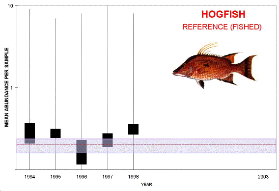
The average annual abundance of economically important reef fish (yellowtail snapper, hogfish, and grouper) were compared to a long-term baseline and between no-take zones and comparable reference sites. Grouper analysis excluded two small rarely targeted species: graysby and coney. Based on our preliminary analysis, the highest average abundances were observed in no-take zones in 1998.
Baseline data were analyzed and used in a new fishery model to do a stock assessment for commonly exploited reef fishes and published (Ault et al, 1998). Results showed that some stocks appear to have been chronically over fished since the late 1970’s. In relation to U.S. federal over fishing standards, 13 of 16 groupers, 7 of 13 snappers, and 2 of 5 grunts are below the 30% SPR over fishing minimum. Evidence indicated some competitive release for barracuda may have occurred in addition to substantial changes in community structure and dynamics. Current efforts are being directed at data trend analysis to define and describe historical performance statistics. Cumulatively, 265 fish species have been observed.
.GIF) |
.GIF) |
.GIF) |
.GIF) |
.GIF) |
.GIF) |
| |
Click on each for a larger image |
|
Volunteer Fish Monitoring
Christy V. Pattengill-Semmens
Reef Environmental Education Foundation, Key Largo, FL
In 1998, Reef Environmental Education Foundation (REEF)’s Advanced Assessment Team (AAT) conducted the second year of reef fish monitoring within the Florida Keys National Marine Sanctuary (FKNMS). The AAT consists of divers highly experienced in field identification and have passed an extensive reef fish identification exam (considered experts in REEF’s database). The AAT monitoring supported by the FKNMS complements REEF’s larger Reef Fish Survey Project that contains over 4,000 volunteer surveys from the Florida Keys. Surveys were completed at 31 sites from Key Biscayne National Park to the Dry Tortugas. These sites included 12 SPAs, 3 Research only, 1 ER, 6 sites in the proposed Dry Tortugas ER area, and 9 comparison/reference sites. The fish assemblages were assessed using the Roving Diver Technique (RDT). During the RDT, the diver has free swimming range around the area, within 100 m radius of the GPS position, and records all fish species present. At the conclusion of the dive, the relative abundance of each species is estimated using one of four log scale categories (1- Single; 2-10- Few; 11-100- Many; >100- Abundant). The abundance data, along with physical parameters, are transferred to an electronically-scannable survey sheet. The survey sheets allow REEF data to be uploaded into a publicly-accessible database that is housed on the Internet (www.reef.org). This visual census method generates a list of species present, along with sighting frequency and relative abundance information. A relative abundance score was used in the analyses, and was calculated for each species as Abund. Score = {((S x 1)+(F x 2)+(M x 3)+(A x 4)) / n} * sighting frequency (%), where S, F, M, and A are the frequency categories of single, few, many, and abundant observations, respectively, and n is the total number of surveys.
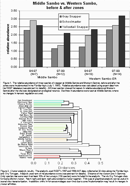
A total of 220 species were documented during the 190 survey hours. Based on the AAT data, there were no obvious trends in abundance or frequency at the species or family level from 1997 to 1998. Spearman’s similarity analysis did show that the similarity of fish assemblages based on species abundance at many of the protected-reference site pairs changed from 1997 to 1998. Seven of the site pairs decreased in similarity (avg. change -0.22), five pairs increased in similarity (avg. change +0.12), and four sites showed no change. This similarity analysis can be repeated in future years to track the effect of implementing the zones. AAT data used in conjunction with the larger REEF database, will provide a more complete picture of pre-zone conditions. In preliminary comparisons using relative abundance of three species of snapper in Western Sambo Ecological Reserve and Middle Sambo (reference site) before and after July 1, 1997, when the zones were implemented, the effect of harvest restrictions was apparent (Figure 1). As more data are collected over time, the ability to detect change in most species will become greater. Using graphical output such as cluster analysis, REEF data can also be used in overall site characterization (Figure 2).
.GIF)
click for a larger image
LOBSTER AND CONCH
Spiny Lobster Monitoring
Carrollyn Cox and John H. Hunt
Department of Environmental Protection, Florida Marine Research Institute, Marathon, FL
Abundance (CPUE) and size of spiny lobsters, Panulirus argus, was monitored in 15 marine reserves and fished reference areas in the Florida Keys National Marine Sanctuary during the closed and open lobster fishing seasons of 1997 and 1998. Thirteen of the no-take zones are small (0.82 ha) Sanctuary Protection Areas (SPAs) or Research Only Areas, one is a large (515 ha) SPA and one is a 3,000 ha Ecological Reserve (ER). Sampling was designed to test the hypothesis that no-take zones would sufficiently protect lobsters so that after establishment, lobsters in the zones would be larger and more abundant than those in unprotected areas. Divers utilized 60 minute timed searches to sample spiny lobsters. Two teams of divers searched for lobsters for 30 minutes each, resulting in the total number of lobsters observed in a 60 minute search (CPUE). Additionally, each lobster larger than 70mm CL captured between Sand Key and Pelican Shoal inclusive was tagged with a uniquely numbered sphyrion tag. Tag number, sex, size, and site of capture data were supplied to Doug Gregory (Monroe County Sea Grant Extension) for use in a Sentinel Fishery sampling program. There were significantly more legal lobsters (>= 76 mm CL) in SPAs than in reference areas during both years. In 1997, CPUE declined in both reserves and reference areas during the open fishing season. This decrease in CPUE was not observed in SPAs during the 1998 open season. Size of legal lobsters did not differ between reserves and reference areas in 1997, but in 1998, legal lobsters in SPAs and the ER were significantly larger than those in reference areas.
click for a larger image
.GIF)
.GIF)
.GIF)
click for a larger image
Back to Table of Contents
Spiny Lobster Sentinel Fishery Program
Douglas R. Gregory, Jr.
University of Florida/Florida Sea Grant, Monroe County Cooperative Extension Service, Key West, FL
The purpose of the sentinel lobster fishery project was to use commercial fishing gear and techniques to evaluate the long-term effectiveness of the Western Sambo Ecological Reserve as a refuge for spiny lobster and to determine if spillover effects were evident in the adjacent fishing areas. The direct involvement of commercial fishermen in this project was an important factor to make the research results as relevant as possible to the commercial fishing community. This was the first year of the planned five-year project.
During 1998, 1329 lobsters were tagged and released in the Reserve and adjacent areas (Middle Sambo and Pelican Shoal). Tag returns to date are inadequate for reliable evaluation. Research sampling recovered 32 tags and the commercial and recreational fisheries returned 26 tags. Most tag returns were from the study sites or areas nearby, but two long distance returns, one each from the shallow oceanside of Big Pine Key and the 7-Mile Bridge were observed. Both lobsters were initially tagged in the Pelican Shoal area. Lobsters within the Reserve exhibited significantly larger carapace length sizes and CPUE than lobsters within the two adjacent areas in both the closed and open fishing seasons, indicating lobsters within the Reserve are experiencing reduced fishing mortality rate relative to lobsters outside the Reserve. The larger lobsters and increased abundance within the reserve were concentrated along the outer reef; the nearshore habitats did not exhibit the same reserve benefits that were observer further offshore. This difference in size and abundance within the reserve appears to be directly related to the relative amounts of coral reef habitat and associated lobster den abundance. Neither lobster size nor CPUE exhibited any evidence of spillover or gradation effects relative to distance from the Reserve.
Continued inter-annual comparisons are needed to evaluate the relative rates of change of size and abundance in the three study areas over time.
Queen Conch Monitoring
Robert Glazer
Florida Department of Environmental Protection, Florida Marine Research Institute, Marathon, FL
In 1997, Florida Department of Environmental Protection began monitoring the marine reserves and adjacent reference sites in the Florida Keys National Marine Sanctuary to assess the effects of marine reserves on populations of queen conch. Two annual surveys have been completed. Up to 20 reserves and 11 references were surveyed each year. Belt-transects were conducted using divers in locations with moderately dense aggregations of conch. Density was measured and the area of each aggregation was estimated in order to facilitate estimates of population abundance. In those areas where conch were sparse, direct counts were made of all individuals present.
In 1997, we estimated that there were approximately 14,450 adult conch associated with 11 reserves. Eight reserves had no conch present and one was not surveyed. (Conch Reef Research Reserve). The aggregations encompassed an area of approximately 26.7 ha and had a mean density of 0.051 adult conch per m2. The references sites contained approximately 6, 200 adult conch within an area estimated to be 11.6 ha. We estimated that the density in the reference area was 0.052 adult conch per m2. Conch populations associated with both the reserves and the references declined in 1998. In the reserve sites, all aggregations declined except Western Sambo and Eastern Dry Rocks. Overall, we estimated that there were approximately 9, 200 adult conch within 14 aggregations. The total area encompassed by these aggregations was 21.3 ha and the mean density was 0.043 conch per m2. Six aggregations contained no conch. During 1998, we located two new aggregations: Conch Reef Research Reserve and Eastern Dry Rocks. In the reference sites, we estimated that there were approximately 4,800 conch in seven locations. These conch aggregations encompassed an area of approximately 11.6 ha. The mean density in these aggregations was 0.077 adult conch m—2 .All reference sites with more than 10 conch declined except for Middle Sambo. There were no statistically significant differences in adult density, aggregation size, or abundance between years or between the reserves and references. However, the overall decline in aggregation area and abundance both within the reserves and the references are alarming and should be monitored closely in future years.
RAPID ASSESSMENT
Coral Community Rapid Assessment
Steven L. Miller and Dione W. Swanson
University of North Carolina, Wilmington, National Undersea Research Center, Key Largo, FL
A coral reef monitoring program based on rapid assessment techniques was implemented in 1998 to document coral community composition and condition in twelve Sanctuary Preservation Areas (SPAs) and adjacent reference sites in the Florida Keys National Marine Sanctuary (FKNMS).
Baselines were established to document community structure and condition over time, to investigate patterns of variation among reefs in the FKNMS, and to evaluate appropriate methods to address both management and ecologically based hypotheses. SPAs were compared to corresponding reference sites to provide a view of reef condition inside and outside managed areas using a rapid assessment approach (data collected on slates are immediately entered into spreadsheets for analysis) and standard video techniques to obtain archival records (tapes processed back in the lab weeks, months, or years later). All sites were sampled using both approaches. Pilot studies were conducted to determine the sampling effort required to detect at least a 5 percent difference among sites in coral cover.
Ten, 25 meter long transects were haphazardly placed at a depth range of 8-10 meters. Scuba divers identified and recorded sessile organisms every 25 cm along each transect line. The size and relative condition of hard coral colonies greater than 5 cm found directly under each transect line were also assessed. The same transects were used for video surveys. Data from both methods were used to calculate percent cover for various categories (hard coral, gorgonians, sponges, bare space, fine turf, crustose coralline algae, thick turf, and erect macroalgae), species diversity (using various diversity indexes) of hard corals, and hard coral colony abundance.
Preliminary results indicate that most SPAs resemble their corresponding reference sites in categories of percent cover and species diversity.
However, patterns with respect to geographic location along the reef tract are not apparent. Twelve sites were resampled 6 weeks after Hurricane Georges (September 25, 1999 landfall in Florida Keys) using the same techniques. Preliminary results documented a decrease in percent cover of thick turf, erect macroalgae and branching gorgonians and an increase in percent cover of bare space, fine turf, and crustose coralline algae at most sites. Changes in percent cover of hard coral varied among sites. The rapid assessment technique provides sufficient power to assess and monitor reefs inside and outside SPAs at regional scales, and for episodic events such as hurricanes. The degree of resolution obtained, and the ability to detect small or large changes over time can be built into monitoring programs from the start (using pilot studies). Decisions about what constitutes a relevant difference falls both in the realm of science and management, and represents one of the most challenging issues facing both disciplines today.
Targeted Marine Life Assessment
Benjamin L. Richards
National Oceanic and Atmospheric Administration, Florida Keys National Marine Sanctuary, Marathon, FL
The collection of marine organisms for the aquarium trade has had drastic effects on many coral reef communities in the indo-Pacific and the Caribbean. While it is clear the collection methods used by tropical marine life collectors in these areas differs greatly from those employed by collectors in the Keys, it is unclear whether the tropical marine life industry is having an effect on local reef communities. While we know a great deal about many of the fish, stony and soft coral, and sponge communities of the Florida Keys, we know much less about many of the reef fish and invertebrate species which make up the coral reef community. This study focuses on a suite of keystone and targeted species whose life history characteristics indicate that they may be highly susceptible to a variety of human influences including water quality fluctuations, incidental catches in trap fisheries, as well as recreational and commercial collecting. By focusing on changes in population levels in the Sanctuary’s SPAs where trapping and collecting are not allowed, this study will gather data that may help in understanding the natural and anthropogenic fluctuations that take place in the reef community.
Data for this study will be collected in five of the Sanctuary’s no-take areas as well as in five reference sites. Data on population numbers will be collected visually by dive teams along ten twenty-five meter transects placed haphazardly at each site. Data will also be gathered on the levels of collection and other extractive fishing practices both inside (poaching) and outside the no-take areas. This information will help managers determine the effectiveness of the SPAs both in protecting biodiversity and in restoring a natural community of reef species.
Rapid Biotic Assessment of Episodic Events
Erich Mueller
Mote Marine Laboratory, Pigeon Key, FL
The RBAT Project is intended to provide an early warning and assessment program for biotic events such as harmful algal blooms ("red tides"), fish kills and coral bleaching that could significantly impact natural resources of the Florida Keys National Marine Sanctuary. There are three major components of the project: 1) the Marine Observer Network of dive and fishing charters, environmental organizations, various agencies and volunteers, 2) Assessment Groups of scientists within various fields of expertise and 3) RBAT Teams that respond to reports meeting various criteria. A RBAT Project Coordinator provides the link between all three. Reports (usually phone calls or email) are logged by the Coordinator and distributed to the appropriate Assessment Group(s). The Assessment Groups do not meet formally but provide feedback to the Coordinator when reports meet criteria for indicating that a "biotic event" is in progress. The criteria are flexible and their development for various events is ongoing. The Coordinator and Project Director initiate investigative responses upon recommendations from the Assessment Groups. The appropriate agencies are contacted and a volunteer pool is drawn upon as needed to form an ad hoc RBAT Team. Their objective is to establish that an event is taking place, its biological extent, spatial extent and obtain samples or other information to help identify what is causing the event. Although these events may be natural in origin, such information assists managers and scientists in understanding the temporary phenomena that may have substantial effects on the functioning of the ecosystem. In cases, where a human cause can be identified, this information allows managers to make decision regarding appropriate actions to take.
.JPG)
click for a larger image