|
What is ATOP? (Last updated 5 July 2005) Advanced Technologies and Oceanic Procedures, otherwise known as ATOP, is a program being implemented at the Federal Aviation Administration’s Air Route Traffic Control Centers (ARTCCs) in New York, Oakland, and Anchorage. ATOP introduces new controller workstations, data processing equipment, and software that will greatly enhance the control and flow of oceanic air traffic to and from the United States. In the current environment, air traffic controllers track and control aircraft using a combination of radar, paper flight progress strips, and voice communications with aircraft and other controlling agencies. Controllers manually estimate aircraft arrival times over points in the routes of flight, and they use multiple rules for keeping aircraft safely separated - based on airspace constraints, aircraft equipment limitations, vertical and lateral spacing, and time, distance, speed, and heading. These “procedural techniques” are most apparent in the oceanic environment, when aircraft fly beyond the coverage of land-based radars. With the expanding volume of oceanic air traffic today, controller workload has increased and more constraints are being imposed on flight routing to maintain safe separation, often causing inconvenience and inefficiency. ATOP is the solution to these problems. In June of 2001, the FAA awarded the ATOP contract to Lockheed Martin Air Traffic Management. ATOP was scheduled to be operational at Oakland Center first, followed by New York, and then Anchorage (for the latest schedule milestones, see Schedule). Anchorage Center was to be the first of the three centers to implement "Build 2", which integrates radar inputs into the ATOP system. The Lockheed Martin solution (sometimes referred to as “Ocean 21”) integrates several Air Traffic Control systems into a single presentation for controllers, and it automates many of the tasks that the controllers presently perform manually. PROGRAM CHANGE: Oakland Center (ZOA) declared Initial Operating Capability (IOC) with the Build 1 software at the end of June 2004. The ATOP Program Office then made the decision in October 2004 to proceed directly with Build 2 software implementation for New York (ZNY) Center's IOC, while concurrently upgrading ZOA to the Build 2 software as well. New York Center achieved its IOC in March 2005. Meanwhile, Anchorage Center (ZAN) slipped to last on the Build 2 waterfall. However, Build 2 at New York and Oakland is not quite the same as the originally envisioned Build 2. Integration of radar inputs - the essential difference between Build 1 and Build 2 software - has not been totally completed yet. Therefore, one must now make the distinction between Build 2 with radar, and Build 2 without radar. A formal System Test of the Build 2 radar functions is scheduled to take place at ZAN in August 2005. Initial Operating Capability for ZAN is scheduled to occur in March 2006.
|
|
 |
 |
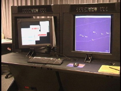
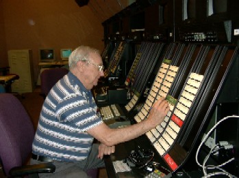
| Paper Flight Strip Bays | Aircraft Situation Display |
|
In the current environment, multiple paper flight progress strips per aircraft are generated, with each strip providing a time estimate over a particular fix (geographic point on an aircraft’s planned route of flight). Strips for a particular fix are organized into bays and manually sorted by the estimated time at the fix to facilitate comparison. As aircraft position reports are received and the time estimates change, all the associated strips have to be updated manually to reflect the new time estimates. The controller continuously scans the strips, searching for loss of separation between aircraft by comparing or extrapolating from the estimated times over fixes. In addition, other important information, such as a change in altitude clearance, is tracked on the strips with hand-written annotations.
|
|
|
|
|
|
A 20" flat panel auxiliary display (left side) replaces the paper flight strip bays on the new ATOP consoles
|
|
|
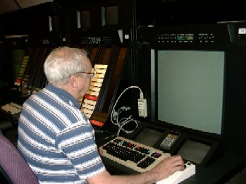
With ATOP, flight data is presented electronically in a format similar to a paper strip; however, only a single strip is used for each aircraft. All position updates (whether from radio operator, data-link systems, radar, or other Air Traffic Control facility) are processed automatically and any resultant changes to estimated times or route information are reflected in the strips without controller intervention.
The Flight Strip Window as it appears on the Auxiliary display.
|
 |
|
An automatic “conflict probe” is the principle reason why multiple strips are not required. The probe assists the controller in detecting traffic conflicts by automatically evaluating traffic situations using the appropriate separation rules based on aircraft equipage, location, or other controller-applied separation standards, such as Mach number technique.
|
|
|
|
|
|
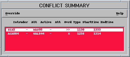
Color displays provide immediate visual cues on all aircraft separation conflicts. |
|
|
|
|
|
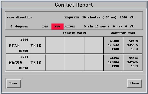
Further amplification on an individual aircraft separation conflict. |
|
| ATOP significantly increases the efficiency of the controller’s search for traffic conflicts. Conflicts are presented to controllers using information-coding that conveys the level of urgency. Notification occurs both on the situation display and in a textual form on the auxiliary display. All clearances are automatically probed, and while awaiting clearance confirmation, the system protects both the current cleared profile for the aircraft as well as the new profile resulting from the outstanding clearance. The controller can also test other routing options for conflicts by using a “trial probe” function.
|
|
|
|
|
|
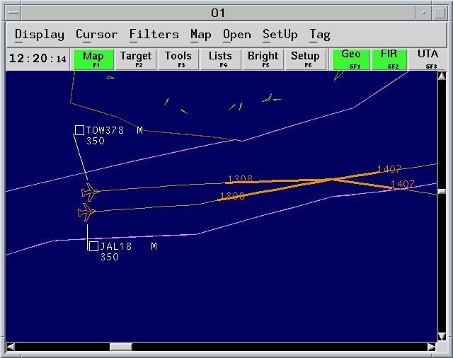
The “conflict probe” feature also provides the controller with a visual presentation of where a future loss of adequate separation will occur. |
|
|
|
|