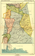
Sample map of Alabama
Note: There are sixty-seven maps
referenced in this volume.
The Library of Congress | American Memory
»Lawmaking Home » Special Presentation
|
Sample map of Alabama Note: There are sixty-seven maps referenced in this volume. |
United States Serial Set Number 4015 contains the second part of the two-part Eighteenth Annual Report of the Bureau of American Ethnology to the Secretary of the Smithsonian Institution, 1896-1897. (Part one is printed in United States Serial Set Number 4014.) Part two, which was also printed as House Document No. 736 of the U.S. Serial Set, 56th Congress, 1st Session, features sixty-seven maps and two tables compiled by Charles C. Royce, with an introductory essay by Cyrus Thomas. The tables are entitled:
The Schedule of Indian Land Cessions subtitle notes that it "indicates the number and location of each cession by or reservation for the Indian tribes from the organization of the Federal Government to and including 1894, together with descriptions of the tracts so ceded or reserved, the date of the treaty, law or executive order governing the same, the name of the tribe or tribes affected thereby, and historical data and references bearing thereon."
The Schedule of Indian Land Cessions comprises 709 entries with links to the related map or maps for each entry. The tables and essays are available in both searchable text and page images and the maps are available in images. Due to the complexity of information presented in each entry, it is strongly recommended that users print out both pages of a table entry for comparison with the related map.
»Lawmaking Home » Special Presentation
The Library of Congress | American Memory