Identification_Information:
Citation:
Citation_Information:
Originator: U.S. Geological Survey (USGS), Coastal and Marine Geology (CMG)
Publication_Date: 20081216
Title:
Geophysical data of field activity S-1-78-SC in Southern
California from 04/17/1978 to 04/29/1978
Publication_Information:
Publisher: U.S. Geological Survey (USGS), Coastal and Marine Geology (CMG)
Online_Linkage: http://walrus.wr.usgs.gov/infobank/gos/s-1-78-sc.fmeta.xml
Online_Linkage: http://walrus.wr.usgs.gov/infobank/s/s178sc/html/s-1-78-sc.meta.html
Description:
Abstract:
Chief Scientist: Dave Cacchione. Geophysical data (12khz,
3dot5khz, underwatercamera, underwatertelevision,
sidescansonar, Geoprobe, CTDmeter, Hydroproducts,
instrumentmooring, transmissometer, integratednavigation,
miniranger, transitsatellite, boxcore, Soutargrab,
VanDornbottle, waterbucket, uniboom) of field activity
S-1-78-SC in Southern California from 04/17/1978 to
04/29/1978,
http://walrus.wr.usgs.gov/infobank/s/s178sc/html/s-1-78-sc.meta.html.
Purpose:
These data and information are intended for science
researchers, students from elementary through
college, policy makers, and general public.
Supplemental_Information:
Equipment Used -
12khz 12 khz bathymetry
3dot5khz 3.5 khz bathymetry
underwatercamera
underwatertelevision
sidescansonar
Geoprobe
CTDmeter
Hydroproducts
instrumentmooring
transmissometer
integratednavigation
miniranger
transitsatellite
boxcore
Soutargrab
VanDornbottle
waterbucket
uniboom
Similar information is available for thousands
of other USGS/CMG-related Activities.
If known, available are Activity-specific
navigation, gravity, magnetics, bathymetry,
seismic, and sampling data; track maps; and
equipment information; as well as summary
overviews, crew lists, and information
about analog materials.
If available, access to physical samples is
described in the "WR CMG Sample Distribution
Policy" at:
http://walrus.wr.usgs.gov/infobank/programs/html/main/sample-dist-policy.html
Primary access to the USGS/CMG Information
Bank's digital data, analog data, and
metadata is provided through...
http://walrus.wr.usgs.gov/infobank/
This page accomodates a variety of search
approaches (e.g., by platform, by region,
by scientist, by equipment type, etc.).
Time_Period_of_Content:
Time_Period_Information:
Range_of_Dates/Times:
Beginning_Date: 19780417
Ending_Date: 19780429
Currentness_Reference: ground condition
Status:
Progress: Complete
Maintenance_and_Update_Frequency: As needed
Spatial_Domain:
Bounding_Coordinates:
West_Bounding_Coordinate: -119.06589
East_Bounding_Coordinate: -117.91488
North_Bounding_Coordinate: 33.91684
South_Bounding_Coordinate: 33.52976
Keywords:
Theme:
Theme_Keyword_Thesaurus: ISO 19115 Topic Category
Theme_Keyword: geoscientificinformation
Theme_Keyword: oceans
Theme:
Theme_Keyword_Thesaurus: USGS CMG InfoBank
Theme_Keyword: Marine Geology
Theme_Keyword: Marine Geophysics
Theme_Keyword: Bathymetry
Theme_Keyword: Water Depth
Theme_Keyword: Seafloor Topography
Theme_Keyword: Marine Seismic
Theme_Keyword: Marine Metering
Theme_Keyword: Current Meters
Theme_Keyword: Hydrologic Current Meter
Theme_Keyword: Instrument Packages
Theme_Keyword: CTD Meter
Theme_Keyword: Conductivity / Temperature / Depth (CDT) Meter
Theme_Keyword: Geoprobe
Theme_Keyword: Instrument Mooring
Theme_Keyword: Turbidity Meters
Theme_Keyword: Transmissometer
Place:
Place_Keyword_Thesaurus: USGS CMG InfoBank
Place_Keyword: CA
Place_Keyword: North Pacific Ocean
Place_Keyword: Northern Pacific Ocean
Place_Keyword: Southern California
Place_Keyword: USA
Access_Constraints:
Physical materials are under controlled on-site access.
If available, access to physical samples is described
in the "WR CMG Sample Distribution Policy" at:
http://walrus.wr.usgs.gov/infobank/programs/html/main/sample-dist-policy.html
Use_Constraints:
Please recognize the U.S. Geological Survey (USGS) as
the source of this information.
Physical materials are under controlled on-site access.
Some USGS information accessed through this means
may be preliminary in nature and presented without
the approval of the Director of the USGS. This
information is provided with the understanding
that it is not guaranteed to be correct or complete
and conclusions drawn from such information are
the responsibility of the user.
This information is not intended for navigational
purposes.
Any use of trade, firm, or product names is for
descriptive purposes only and does not imply
endorsement by the U.S. Government.
Point_of_Contact:
Contact_Information:
Contact_Organization_Primary:
Contact_Organization: U.S. Geological Survey (USGS), Coastal and Marine Geology (CMG)
Contact_Person: Clint Steele
Contact_Position: Data Acquisition, Processing, and Storage (DAPS) Group Leader
Contact_Address:
Address_Type: mailing and physical address
Address: USGS, MailStop 999, 345 Middlefield Road
City: Menlo Park
State_or_Province: CA
Postal_Code: 94025-3561
Country: USA
Contact_Voice_Telephone: (650) 329-5055
Contact_Facsimile_Telephone: (650) 329-5190
Contact_Electronic_Mail_Address: csteele@usgs.gov
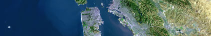
Browse_Graphic:
Browse_Graphic_File_Name: http://walrus.wr.usgs.gov/infobank/s/s178sc/html/s-1-78-sc.nav.gif
Browse_Graphic_File_Description: Trackline map of S-1-78-SC
Browse_Graphic_File_Type: GIF
Browse_Graphic:
Browse_Graphic_File_Name: http://walrus.wr.usgs.gov/infobank/s/s178sc/html/s-1-78-sc.bath.gif
Browse_Graphic_File_Description: Bathymetry data trackline map of S-1-78-SC
Browse_Graphic_File_Type: GIF
Browse_Graphic:
Browse_Graphic_File_Name: http://walrus.wr.usgs.gov/infobank/s/s178sc/html/s-1-78-sc.samp.gif
Browse_Graphic_File_Description: Sampling locations map of S-1-78-SC
Browse_Graphic_File_Type: GIF
Data_Set_Credit:
Brian Edwards (Oceanographer, USGS Western Region);
Carol Madison (Navigator, USGS Western Region);
Chuck Totman (Watchstander, USGS Western Region);
Dave Cacchione (Chief Scientist, USGS Western Region);
Dave Drake (Oceanographer, USGS Western Region);
Ed Clukey (Watchstander, USGS Western Region);
George Tate (Watchstander, USGS Western Region);
Herman Karl (Oceanographer, USGS Western Region);
J. Bassin (Watchstander, USGS Western Region);
Jim Nicholson (Electronics Technician, USGS Western Region);
Neal Barnes (Watchstander, USGS Western Region);
Pat Wiberg (Dafe Curator, USGS Western Region);
S. Thornton (Watchstander, USGS Western Region)
Native_Data_Set_Environment: Digital, ASCII
Cross_Reference:
Citation_Information:
Originator: U.S. Geological Survey (USGS), Coastal and Marine Geology (CMG)
Publication_Date: Unknown
Title: USGS/CMG Information Bank
Publication_Information:
Publisher: U.S. Geological Survey (USGS), Coastal and Marine Geology (CMG)
Other_Citation_Details: Updated daily
Online_Linkage: http://walrus.wr.usgs.gov/infobank/
Data_Quality_Information:
Attribute_Accuracy:
Attribute_Accuracy_Report: Identified as best available version.
Logical_Consistency_Report: Unspecified
Completeness_Report:
Start and end date/times of data
>Navigation Data (s-1-78-sc.010 [DRS])
>YYYYMMDDHHMMSST YYYYMMDDHHMMSST
>197804172201300 197804172202060
>197804172209060 197804172211060
>197804180204150 197804182118040
>197804182124040 197804191633200
>197804191639200 197804191803200
>197804191849070 197804191855070
>197804191905090 197804191933280
>197804191943280 197804192229190
>197804192241240 197804202040070
>197804202100040 197804202100040
>197804202125250 197804231732410
>197804231750420 197804250211020
>197804250217030 197804261125070
>197804261130520 197804290022090
>197804290028030 197804290201040
>YYYYMMDDHHMMSST YYYYMMDDHHMMSST
>Bathymetry Data (s-1-78-sc.330_010)
>YYYYMMDDHHMMSST YYYYMMDDHHMMSST
>197804172201300 197804172201300
>197804180204150 197804180214170
>197804180232050 197804180245320
>197804191233170 197804191241160
>197804191503180 197804191503180
>197804191539170 197804191615180
>197804191633200 197804191633200
>197804191639200 197804191715200
>197804191733200 197804191803200
>197804191913090 197804191915090
>197804191933280 197804191933280
>197804192047280 197804192047280
>197804192249240 197804192251240
>197804200257010 197804200307010
>197804201203470 197804201215470
>197804201235240 197804201315190
>197804201333230 197804201414120
>197804201433050 197804201459290
>197804210141040 197804210214020
>197804210232020 197804210314020
>197804210547590 197804210547590
>197804210733590 197804210815080
>197804210833130 197804210915130
>197804211402480 197804211412480
>197804211432480 197804211515360
>197804211533370 197804211601390
>197804211609390 197804211613390
>197804211632120 197804211652120
>197804211658120 197804211714120
>197804211732140 197804211734140
>YYYYMMDDHHMMSST YYYYMMDDHHMMSST
Positional_Accuracy:
Horizontal_Positional_Accuracy:
Horizontal_Positional_Accuracy_Report: Unspecified
Vertical_Positional_Accuracy:
Vertical_Positional_Accuracy_Report: Unspecified
Lineage:
Process_Step:
Process_Description:
Navigation Data
>Converted to time format with year at start.
>
>01/16/86 KAYE DUA0:[DATA.S178SC.N]S178SC.010;
>DRB0:[DRS.REFMT]REFORMAT.EXE;5
>
Process_Date: 19951206
Process_Contact:
Contact_Information:
Contact_Organization_Primary:
Contact_Organization: U.S. Geological Survey (USGS), Coastal and Marine Geology (CMG)
Contact_Person: Clint Steele
Contact_Position: Data Acquisition, Processing, and Storage (DAPS) Group Leader
Contact_Address:
Address_Type: mailing and physical address
Address: USGS, MailStop 999, 345 Middlefield Road
City: Menlo Park
State_or_Province: CA
Postal_Code: 94025-3561
Country: USA
Contact_Voice_Telephone: (650) 329-5055
Contact_Facsimile_Telephone: (650) 329-5190
Contact_Electronic_Mail_Address: csteele@usgs.gov
Process_Step:
Process_Description:
Bathymetry Data
>10/31/1998 /tiger/s/s178sc/bath/s-1-78-sc.330_010
>/bear/programs/edit/automerge/automerge
>
>Input was...
>Converted to time format with year at start.
>
>11/30/90 CAROLYN DUA0:[DRS.NGDC.CDWORK]S178SC.330;1
>DUA0:[DRS.BAT]BATRED.EXE;2
>Edited bathymetry data
>using velocity = 1463.0 m/sec for MGD-77 format
>
>02/13/86 BECKIE DISK$USERDISK:[CLINT.BECKIE]S178SC.301;
>DRB0:[DRS.REFMT]REFORMAT.EXE;5
>This is digitrack bathy of dubious quality.
>
>Input was...
>Converted to time format with year at start.
>
>01/16/86 KAYE DUA0:[DATA.S178SC.N]S178SC.010;
>DRB0:[DRS.REFMT]REFORMAT.EXE;5
>
>time, lat, long, time(sec) to nearest nav fix, data values
Process_Date: 19981031
Process_Contact:
Contact_Information:
Contact_Organization_Primary:
Contact_Organization: U.S. Geological Survey (USGS), Coastal and Marine Geology (CMG)
Contact_Person: Clint Steele
Contact_Position: Data Acquisition, Processing, and Storage (DAPS) Group Leader
Contact_Address:
Address_Type: mailing and physical address
Address: USGS, MailStop 999, 345 Middlefield Road
City: Menlo Park
State_or_Province: CA
Postal_Code: 94025-3561
Country: USA
Contact_Voice_Telephone: (650) 329-5055
Contact_Facsimile_Telephone: (650) 329-5190
Contact_Electronic_Mail_Address: csteele@usgs.gov
Spatial_Data_Organization_Information:
Indirect_Spatial_Reference: Southern California
Direct_Spatial_Reference_Method: Point
Point_and_Vector_Object_Information:
SDTS_Terms_Description:
SDTS_Point_and_Vector_Object_Type: Point
Spatial_Reference_Information:
Horizontal_Coordinate_System_Definition:
Geographic:
Latitude_Resolution: 0.00001
Longitude_Resolution: 0.00001
Geographic_Coordinate_Units: Decimal degrees
Geodetic_Model:
Horizontal_Datum_Name: North American Datum of 1927
Ellipsoid_Name: Clarke 1866
Semi-major_Axis: 6378206.4
Denominator_of_Flattening_Ratio: 294.98
Vertical_Coordinate_System_Definition:
Depth_System_Definition:
Depth_Datum_Name: Local surface
Depth_Resolution: 0.1
Depth_Distance_Units: meters
Depth_Encoding_Method: Attribute values
Entity_and_Attribute_Information:
Overview_Description:
Entity_and_Attribute_Overview: Bathymetry with Time Stamp
Entity_and_Attribute_Detail_Citation:
Edited bathymetry data
>Mnemonic: (Year, Day, Hour, Min, Sec, Tenths, 2WayTravelTime, UncorrDepth)
>FORTRAN format: (i4.4, i3.3, 3i2.2, i1.1, t16, f7.4, t23, f7.1)
>C format: (%4.4i%3.3i3%2.2i%1.1i %7.4f %7.1f\\n)
>Naming: .330
Overview_Description:
Entity_and_Attribute_Overview: Navigation with Time Stamp
Entity_and_Attribute_Detail_Citation:
Dead reckoning data
>Mnemonic: (Year, Day, Hour, Min, Sec, Tenths, Latitude, Longitude)
>FORTRAN format: (i4.4, i3.3, 3i2.2, i1.1, t16, f9.5, t26, f10.5)
>C format: (%4.4i%3.3i3%2.2i%1.1i %9.5f %10.5f\\n)
>Naming: .010
Distribution_Information:
Distributor:
Contact_Information:
Contact_Organization_Primary:
Contact_Organization: U.S. Geological Survey (USGS), Coastal and Marine Geology (CMG)
Contact_Person: Clint Steele
Contact_Position: Data Acquisition, Processing, and Storage (DAPS) Group Leader
Contact_Address:
Address_Type: mailing and physical address
Address: USGS, MailStop 999, 345 Middlefield Road
City: Menlo Park
State_or_Province: CA
Postal_Code: 94025-3561
Country: USA
Contact_Voice_Telephone: (650) 329-5055
Contact_Facsimile_Telephone: (650) 329-5190
Contact_Electronic_Mail_Address: csteele@usgs.gov
Resource_Description: Downloadable Data S-1-78-SC data set
Distribution_Liability:
Please recognize the U.S. Geological Survey (USGS) as
the source of this information.
Physical materials are under controlled on-site access.
Some USGS information accessed through this means
may be preliminary in nature and presented without
the approval of the Director of the USGS. This
information is provided with the understanding
that it is not guaranteed to be correct or complete
and conclusions drawn from such information are
the responsibility of the user.
This information is not intended for navigational
purposes.
Any use of trade, firm, or product names is for
descriptive purposes only and does not imply
endorsement by the U.S. Government.
Standard_Order_Process:
Digital_Form:
Digital_Transfer_Information:
Format_Name: ASCII
File_Decompression_Technique: No compression applied
Transfer_Size: 0.3
Digital_Transfer_Option:
Online_Option:
Computer_Contact_Information:
Network_Address:
Network_Resource_Name: http://walrus.wr.usgs.gov/infobank/s/s178sc/html/s-1-78-sc.nav.html
Digital_Form:
Digital_Transfer_Information:
Format_Name: ASCII
File_Decompression_Technique: No compression applied
Transfer_Size: 0.0
Digital_Transfer_Option:
Online_Option:
Computer_Contact_Information:
Network_Address:
Network_Resource_Name: http://walrus.wr.usgs.gov/infobank/s/s178sc/html/s-1-78-sc.bath.html
Fees: None
Metadata_Reference_Information:
Metadata_Date: 20081216
Metadata_Contact:
Contact_Information:
Contact_Organization_Primary:
Contact_Organization: U.S. Geological Survey (USGS), Coastal and Marine Geology (CMG)
Contact_Person: Clint Steele
Contact_Position: Data Acquisition, Processing, and Storage (DAPS) Group Leader
Contact_Address:
Address_Type: mailing and physical address
Address: USGS, MailStop 999, 345 Middlefield Road
City: Menlo Park
State_or_Province: CA
Postal_Code: 94025-3561
Country: USA
Contact_Voice_Telephone: (650) 329-5055
Contact_Facsimile_Telephone: (650) 329-5190
Contact_Electronic_Mail_Address: csteele@usgs.gov
Metadata_Standard_Name: FGDC Content Standards for Digital Geospatial Metadata
Metadata_Standard_Version: FGDC-STD-001-1998
Metadata_Time_Convention: universal time
Metadata_Access_Constraints: none
Metadata_Use_Constraints: none
|