Havana Harbor and the Island
of Cuba
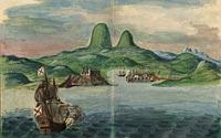
Johannes Vingboons (1665-1670)
Havana Op't Eylant
Cuba (Havana Harbor)
Gift of Henry Harrisse, 1915 (20.8)
Digital ID: http://hdl.loc.gov/loc.gmd/g4924h.lh000348
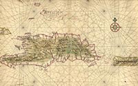
Cuba
Colored pen-and-ink manuscript maps,ca. 1665
Geography & Map Division
Gift of Henry Harrisse, 1915 (20.9)
Digital ID: http://hdl.loc.gov/loc.gmd/g4930.ct000952
|
This panoramic view of Havana harbor and vicinity by Johannes
Vingboons emphasizes the strong fortifications protecting the city.
View shows fortifications, city buildings, ships, the harbor, the
nearby countryside including erroneous peaks looming over the harbor.
Johannes Vingboons, a cartographer in the employ of the Dutch West
India Company, produced maps for more than thirty years for use
by Dutch mercantile and military shipping. Vingboons' map of the
island of Cuba includes coastline, coastal features, soundings,
navigational hazards, settlements, and streams.
|