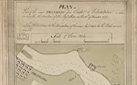
Part of the Delaware River
John Hunter (1738-1821)
Plan of part of the River Delaware from
Chester to Philadelphia in which is mark'd the position of His
Majesty's ships on the 15th of November 1777
Manuscript map, with ink and watercolor
Geography & Map Division (21C.9)
|
During the Revolution, British strategy was to undermine
the cause from within by gaining support of Loyalists and slaves. This plan
of a fifteen-mile stretch
of the Delaware below Philadelphia belonged to British Admiral Richard
Howe. It includes the "Obstructions to the Navigation of the river laid down by
the Rebels," and shows the location of fortifications, such as Mud Island
and Red Bank. These defenses failed to prevent British occupation of Philadelphia
in 1777.
|